AVALANCHE WARNING!! Tap for info

Forecast for the Provo Area Mountains

Dave Kelly
Issued by Dave Kelly on
Sunday morning, February 2, 2025
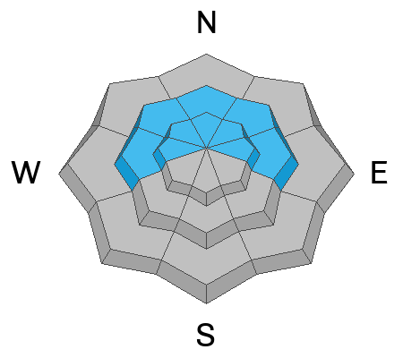
The avalanche danger is CONSIDERABLE at all aspects and elevations where it will be likely for humans to trigger avalanches failing on a layer of weak sugary faceted snow now buried under new snow and wind drifts. These avalanches could be 1'-3' deep and could be larger if they involve the facets near the ground.
With warming temperatures and rain up to 8,500' there is a possibility of wet snow avalanches in lower elevation terrain. This is of particular concern to ice climbers who spend most of their time in exposed gullies in avalanche paths. Be certain of what's above you before starting your ascent.
Strong winds created fresh wind-drifts at mid and upper elevations. These drifts may break above you; and can be avoided by choosing to travel on lower angle, less than 30° slopes out of the wind zone.
Low
Moderate
Considerable
High
Extreme
Learn how to read the forecast here
Weather and Snow
Under partly cloudy skies trailhead temperatures are in the low 40's °F and the highest peaks are in the 20's °F. Winds are blowing from the southwest in the 30's gusting to the 50's MPH at the 8,000' ridgelines and possibly rimed at the upper weather stations. Storm totals range from 1"-7" snow with .8" water.
Today, under partly cloudy skies we can expect to see 1" of snow with up to .15" of water and a freezing level hovering around 8,500' in elevation. There is a possibility of rain at lower elevations. Temperatures are forecast to be 38-44°F with winds blowing strong from the southwest 20 gusting to 30 MPH at the lower ridgelines and from the southwest 55 gusting to 80 at the highest ridgelines.
Recent Avalanches
Yesterday, there were no reports of backcountry avalanches from the Provo Forecast Region. You can find all recent observations and avalanches HERE.
Ad
Avalanche Problem #1
Wind Drifted Snow
Type
Location
Likelihood
Size
Description
Strong winds have drifted new snow into stiff drifts that now sit on top of an old weak sugary faceted snow surface. These drifts will not bond well to the old snow surface. Look for and avoid pillowy, rounded piles of snow. Shooting cracks, cornices, and collapsing are all signs of wind-drifted snow and these are areas to avoid. Drifts may appear lower on the slope and further down ridgelines than you may expect.
Avalanche Problem #2
Persistent Weak Layer
Type
Location
Likelihood
Size
Description
There are currently two buried weak layers in our snowpack. One is a layer of buried near-surface facets that formed during last week's cold clear weather. This layer will not bond well to the newest snow or recent wind drifts and expect to see sloughing and loose new snow avalanches on this layer.
The second layer is buried near the ground. This layer was formed in December and was responsible for many large avalanches during the Holiday Avalanche Cycle. This layer will be more likely to be triggered as the storm continues and we could see avalanches 1'-3' deep. The most likely places to trigger an avalanche on this layer of buried facets are steep slopes that have a thinner snowpack, rocky gully features, and areas that previously avalanched (repeaters).
Read more about persistent weak layer avalanches HERE.
Avalanche Problem #3
Wet Snow
Type
Location
Likelihood
Size
Description
With base building snow falling yesterday followed up by rain and above average temperatures today be on the look for and avoid wet loose avalanches in mid and lower elevation terrain. These will most likely occur in steep rocky gully features and may not be enough to bury you, but combined with buried facets near the ground there is an off chance of a lower elevation wet avalanche that breaks out more as a slab avalanche. Any dry snow avalanche that trenches down to wet snow would be bigger and have more mass. Stay off of slopes where you start to sink through the snowpack to the ground with your skis or board.
These wet snow avalanches are something that ice climbers and hikers may want to pay attention to as they can often start as dry snow avalanches and run down into lower elevation terrain. The thing to remember is you don't have to be in the starting zone to be involved in an avalanche. The track (ice climbers) or runout (hikers) are likely places to be caught in an avalanche as well. Read more about avalanche paths HERE.
General Announcements
This information does not apply to developed ski areas or highways where avalanche control is normally done. This forecast is from the U.S.D.A. Forest Service, which is solely responsible for its content. This forecast describes general avalanche conditions and local variations always occur.