Join us at our 2nd Annual Blizzard Ball

Forecast for the Skyline Area Mountains

Brett Kobernik
Issued by Brett Kobernik on
Saturday morning, January 4, 2025
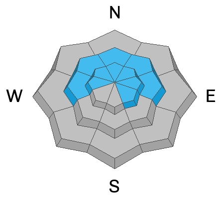
The overall danger rating is CONSIDERABLE today on the Manti Skyline.
With snow and strong wind expected today, the danger will be increasing.
You will want to avoid being on or below slopes steeper than about 30˚ especially on the north half of the compass.
Low
Moderate
Considerable
High
Extreme
Learn how to read the forecast here
Weather and Snow
Current Conditions: Here's a "week in review" video:
Temperatures remained mild overnight but the cold front is upon us with light snow starting to fall. Wind speeds have increased from the southwest in the last few hours.
Mountain Weather: A storm moves through today in a cold northwest flow. My guess is we'll see an average of 3 to 5 inches of snow across the range but some areas favored by a northwest flow, like Ephraim Canyon could see more. Wind will shift from the southwest to the northwest and speeds are going to get pretty strong, especially this afternoon.
Ad
Avalanche Problem #1
Persistent Weak Layer
Type
Location
Likelihood
Size
Description
You're biggest concern today is triggering an avalanche that breaks into older sugary faceted snow deep in the snowpack. Todays additional snow and wind drifted snow will increase the chances for triggering something. The most dangerous areas are slopes steeper than 30˚ above 8000 feet in elevation that face west, north and east. These areas are where the old faceted weak layers are most pronounced.
.
Avalanche Problem #2
Wind Drifted Snow
Type
Location
Likelihood
Size
Description
Wind is going to stir things up today. It will take snow from one area and deposit it in another. The most dangerous places are where these deposits land in locations with buried weak faceted snow as described above. However, the drifts on their own may be sensitive and may get large enough to cause trouble even if there is no old faceted snow present. They can be scattered all over. Watch for "pillowy" looking formations and avoid them. Most likely places for trouble are right along ridgelines.
General Announcements
This forecast is from the U.S.D.A. Forest Service, which is solely responsible for its content. This forecast describes general avalanche conditions and local variations always occur.