AVALANCHE WARNING!! Tap for info

Forecast for the Ogden Area Mountains

Trent Meisenheimer
Issued by Trent Meisenheimer on
Thursday morning, December 26, 2024
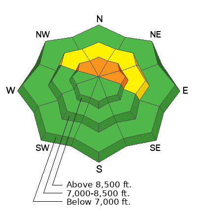
This morning, we have a MODERATE avalanche danger that will rise to CONSIDERABLE across upper elevation slopes facing northwest, north, northeast, and east, where it will become likely to trigger an avalanche 1-2 feet deep, failing on a persistent weak layer of faceted snow.
There is also a MODERATE avalanche danger on mid-elevation slopes facing northwest through east for triggering an avalanche 1-3 feet deep that fails on a persistent weak layer of faceted snow.

With strong wind and heavy snowfall, the avalanche danger will rise over the next 24 to 48 hours.
Low
Moderate
Considerable
High
Extreme
Learn how to read the forecast here
Avalanche Watch
What: Heavy snowfall and drifting by strong winds will elevate backcountry avalanche danger over the next several days. Very dangerous conditions and HIGH avalanche danger are expected to develop in many areas
When: The Avalanche Watch is for rising avalanche danger, with very dangerous conditions continuing through the weekend and into next week.
Where: The Avalanche Watch is for the mountains of Northern and Central Utah as well as Southeastern Idaho, including The Wasatch Range. The Bear River Range. The Western Uinta Mountains and The Wasatch Plateau.
Impacts: Very dangerous avalanche conditions are expected to develop on many slopes. Avalanches can be triggered on slopes steeper than 30 degrees. They may also be triggered remotely (from a distance) or from below.
What to do: Avoid traveling on or underneath steep terrain at mid and upper elevations in the backcountry. Carry and know how to use avalanche rescue equipment. Find safer riding conditions on slopes less than 30 degrees with no overhead hazard.
Weather and Snow
Under partly cloudy skies, the first few snowflakes are falling, and mountain temperatures are cold ranging from 15-28 °F. In the past few hours, the wind has picked up out of the southwest, blowing 10-15 mph with gusts into the 20s across the upper elevations. On Ogden Peak the wind is blowing from the southwest at 25-30 mph. Within the past 48 hours, we've seen roughly 2-5 inches of snow with 0.10-0.40 inches of snow water equivalent (swe).
The National Weather Service has issued a winter storm warning for a series of winter storms that will impact northern Utah over the next few days. This morning, we should see snow begin to fill the area around 8:00 AM, with 2-5 inches of new snow (0.10-0.50 swe) throughout the day today. The wind is forecast to pick up in the next few hours and blow from the west at speeds of 15-25 mph with gusts into the 30s and 40s across the upper elevations.
This evening, a small cold front embedded in the flow will cross over northern Utah, bringing more snow overnight into Friday. All said and done, we could see 15 to 30 inches of new snow (1.50-3.0 swe) by Monday (see total precipitation map below).
Recent Avalanches
No new avalanche activity was reported yesterday. On Tuesday, there was a very close call in Logan, where a rider was fully buried.
Ad
Avalanche Problem #1
Persistent Weak Layer
Type
Location
Likelihood
Size
Description
Throughout northern Utah, we have a very weak and faceted snowpack on almost all shady slopes. If you look at the locator rose you will see the aspects and elevations highlighted in blue where the backcountry community and we have identified where this persistent weak layer of faceted snow exists (pwl).
Faceted snow is not dangerous until you add stronger, more cohesive snow (slab) over it. A slab over faceted snow (pwl) is the perfect recipe for avalanches that catch, carry, and kill most backcountry riders. In fact, it's responsible for roughly 70% of all avalanche fatalities.
Today, we have a rising avalanche danger as we build a slab of snow over this weak snow. Strong wind and heavy snowfall will overload the snowpack, creating dangerous avalanche conditions. I would avoid slopes steeper than 30 degrees in steepness and remember that an avalanche can be triggered remotely (from a distance).
Video: Discussion about the snowpack for all mountains in northern Utah.
Additional Information
An avalanche watch means we will likely transition into an avalanche warning within 24 hours.
General Announcements
This information does not apply to developed ski areas or highways where avalanche control is normally done. This forecast is from the U.S.D.A. Forest Service, which is solely responsible for its content. This forecast describes general avalanche conditions and local variations always occur.