Join us at our 2nd Annual Blizzard Ball

Forecast for the Provo Area Mountains

Trent Meisenheimer
Issued by Trent Meisenheimer on
Sunday morning, December 22, 2024
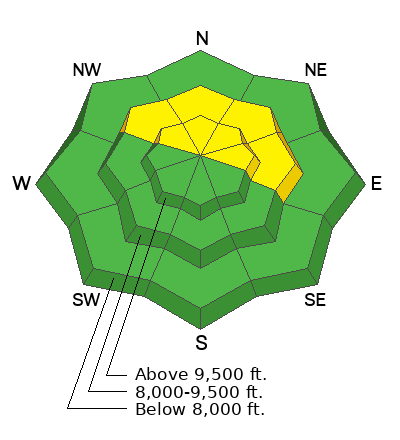
The avalanche danger is MODERATE on mid and upper-elevation slopes facing northwest through north through east. It is possible to trigger an avalanche 1-2 feet deep, failing on a persistent weak layer of faceted snow. Recently, wind-loaded slopes at the upper elevations have been the most prone to avalanches.
Low
Moderate
Considerable
High
Extreme
Learn how to read the forecast here
Special Announcements
Now is a great time to dial in your safety gear, including putting fresh new batteries in your beacons! Local shops across the state will be handing out free Batteries for Beacons from now until February 1, 2025. All you need to do is fill out a quick survey and grab the AAA or AA batteries you need to keep your beacon fresh this season. Find participating shops and more info here.
Weather and Snow
Under partly cloudy skies, the mountain temperatures remain warm and range from 26-42 °F. The wind is generally from the southwest and wind speeds are 10-15 mph with gusts into the 20s.
Let's hope today we can squeeze some snow from two very weak storms that will impact the area later today through Monday. We should see snow begin later this afternoon that will likely spit and sputter here and there. Accumulations are expected to be trace to two inches of snow through Monday.
Starting Christmas, the pattern looks much more active, and it looks like snow and winter will return to Utah.
Recent Avalanches
No new avalanche activity was reported yesterday. Both Nikki Champion and Dave Kelly went to Provo for field work and made great observations that are worth reading.
Ad
Avalanche Problem #1
Persistent Weak Layer
Type
Location
Likelihood
Size
Description
A persistent weak layer (PWL) of faceted snow exists on northerly-facing slopes at the mid and upper-level elevations where it is possible to trigger an avalanche up to 1-2 feet deep and over 100 feet wide. Avalanche activity and field work this week has informed us that the slopes that are most prone to slide are recently wind-loaded and/or have a slab of stronger snow on top of the buried PWL. Even though the video below is from Big Cottonwood, it demonstrates the setup where you would most likely trigger an avalanche (see video).
Video: Greg Gagne
General Announcements
This information does not apply to developed ski areas or highways where avalanche control is normally done. This forecast is from the U.S.D.A. Forest Service, which is solely responsible for its content. This forecast describes general avalanche conditions and local variations always occur.