UDOT PLANNED AVALANCHE CLOSURES!!

Forecast for the Uintas Area Mountains

Craig Gordon
Issued by Craig Gordon on
Saturday morning, March 30, 2024
Avy danger is straight-forward today, but look for changes to round out the weekend as yet another robust storm sets its sights on northern Utah-
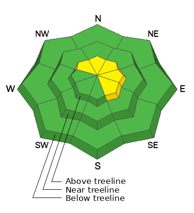
In the wind zone at and above treeline you'll find MODERATE avalanche danger. Human triggered avalanches are POSSIBLE on steep, wind drifted slopes, especially in terrain facing the north half of the compass, and particularly on slopes with an easterly component to their aspect.
Wind sheltered terrain at mid and low elevations offer LOW avalanche danger and human triggered avalanches are UNLIKELY.
Low
Moderate
Considerable
High
Extreme
Learn how to read the forecast here
Special Announcements
Please help support the UAC rebuild our website backend platform to ensure the ongoing security of the website and the data stored on the site by donating to our spring campaign. Save lives by making a donation today!
Weather and Snow
Nowcast- Thick clouds settled in overnight, delivering about 3" of medium density snow across the range. We're in the warm sector of an upcoming storm and accordingly, temperatures are about 10 degrees warmer than yesterday at this time, hovering in the mid and upper 20's. Winds blow 20-30 mph from the south along the ridges, gusting into the 40's and 50's near the high peaks. Yesterday's cloud cover, coupled with warm, moist air threw a cargo net on lower elevation terrain and I suspect you'll find a zipper crust on the surface. But, don't let your heart be troubled... mid and upper elevation slopes facing the north half of the compass offer 5 star riding conditions.
Forecast- Expect on-again/ off-again snow showers during the day with an additional 3"-5" of warm, dense snow piling up. Temperatures climb into the mid 30's while southerly winds remain obnoxious along the ridges.
Futurecast- Another shot of moisture teams up with colder air and that combo rolls into the region Sunday morning. We can look forward to lower density snow with 6"-10" stacking up by days end.
March Madness continues as The Lion of Zion announces a Winter Weather Advisory for the western Uinta area.
Recent Avalanches
No significant avy activity to report from yesterday-
Mark was in Smith-Moorehouse and has a most excellent recap of his travels above.
Meanwhile Ted was in Whiskey Creek and reports great riding and straight-forward avy danger and I found the same in Upper Weber Canyon.

For all Uinta observations and archived avalanche activity click HERE.
Ad
Avalanche Problem #1
Wind Drifted Snow
Type
Location
Likelihood
Size
Description
24 hour data dump from Lofty Lake Peak seen in the image above (11,186'). Please focus on wind speed and direction and disregard temp profile... the sensor is whacked
It's been an active week of weather with fresh snow stacking up nearly everyday. And while most of our recent drifts have been manageable in size, fact is, we have a weeks worth of storm snow and those layers are camouflaged by last nights fresh snow, making them hard to detect. The good news is... most of our issues are in upper elevation, leeward terrain and we can avoid the problem by avoiding terrain where today's avalanche dragon lives.
You know the drill... lose the wind and you loose the problem and score a great day of riding to boot!
Additional Information
The Uinta weather station network was upgraded this summer and all that real-time info is found HERE. Simply click on "western Uinta" tab and then "weather stations" tab.

We are always looking for snow and avalanche observations or just general riding conditions. So... if you see something, say something. You can reach me directly at [email protected] or 801-231-2170.
Also, if you're looking for more avy education opportunities for yourself, your crew, or your club please don't hesitate to reach out to me and we'll find a presentation, class, or clinic for ya!
General Announcements

Issued at 03:30 on Saturday, March 30th this forecast will be updated by 0700 Sunday, March 31st, 2024.
This forecast is from the U.S.D.A. Forest Service, which is solely responsible for its content. This forecast describes general avalanche conditions and local variations always occur.