31st Annual Backcountry Benefit - September 12th - Tickets Available Here!

Forecast for the Uintas Area Mountains

Mark Staples
Issued by Mark Staples on
Sunday morning, March 31, 2024
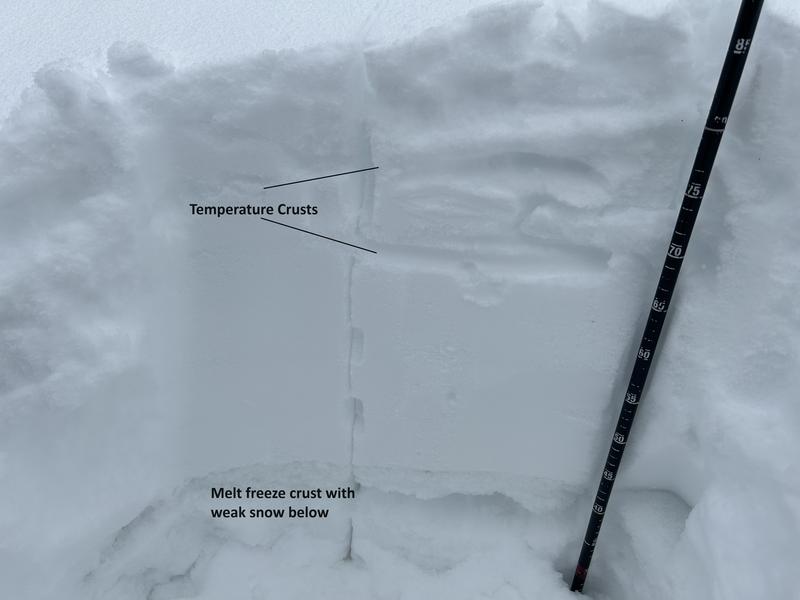
The Easter Bunny has been delivering snow for the last handful of days and the powder is stacking up.
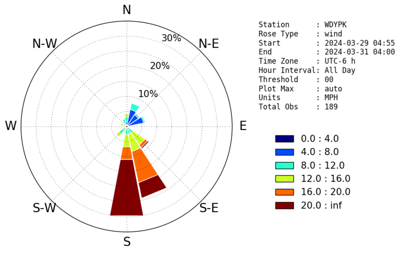
I am certain that the wind has been drifting some of that powder above treeline (and to a lesser degree near treeline) where there should be soft slabs of wind drifted snow you can trigger.
I am uncertain about the stability of the new snow on slopes that haven't been touched by winds where soft slab avalanches in the new snow are possible.
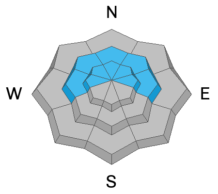
Today the avalanche danger is CONSIDERABLE above treeline where more snow has fallen and winds from the south and southeast have been blowing.
Near treeline where there is still a decent amount of new snow but not as much wind, the danger is MODERATE.
Below treeline with less snow and less wind, the danger is LOW.
Low
Moderate
Considerable
High
Extreme
Learn how to read the forecast here
Special Announcements
Please help support the UAC rebuild our website backend platform to ensure the ongoing security of the website and the data stored on the site by donating to our spring campaign. Save lives by making a donation today!
Weather and Snow
The snow continues to stack up with an additional 5-7 inches of snow falling since yesterday (most of it overnight). Snowfall at the Trial Lake SNOTEL site since Tuesday morning has added up to 26 inches that has settled to 17 inches containing 3.6 inches of water.
This morning temperatures didn't cool off much under cloudy skies and are hovering mostly in the upper 20s F. Winds on the high peaks are blowing 29 mph gusting to 37 mph from the SSE.
Today more snow should fall early this morning, then tapering off midday, and possibly picking up again this evening. A cold front will be competing with normal daytime heating, and high temperatures should remain just under freezing. Winds at upper elevation ridgelines will continue from the south and may bump up a little bit averaging about 30 mph (perfect speeds for drifting snow).
Between snowfall this morning and this evening, there should be another 5-6 inches of new snow by tomorrow morning. Snowfall ends Monday with the next chance on Friday. Cold air stays overhead through Tuesday followed by a pretty good warm up Wednesday and Thursday, but another cold front should push through sometime Friday with some strong south winds ahead of it.

Conditions are 5-star at upper elevations facing north where you'll find deep powder (photo below). Moments of sunshine and warm temperatures over the last four days have created several ice crusts. These are thicker and harder on southerly facing slopes and at low elevation slopes.
Photo from the northern part of the Uintas from Saturday (A. Gile)
Recent Avalanches
There was one soft slab of wind drifted snow reported on Friday near Hoyt Peak triggered by snowmobilers.

For all Uinta observations and archived avalanche activity click HERE.
Ad
Avalanche Problem #1
Wind Drifted Snow
Type
Location
Likelihood
Size
Description
With all the new snow, more snow falling this morning, and wind speeds around 30 mph - there will be soft slabs of wind drifted snow forming today. These wind slabs will mostly be above treeline where they will be thicker (several feet thick) and much easier to trigger. Look for them near treeline as well. The avalanche from Hoyt's Peak is a good example of what to expect today.
Fortunately this problem is easy to avoid by simply riding terrain where winds haven't drifted any snow.
The wind rose diagram below shows the distribution of wind speed and direction from the last 48 hours on Windy Peak.
Avalanche Problem #2
New Snow
Type
Location
Likelihood
Size
Description
I am unsure how well the new snow is bonding to itself and underlying surfaces. On Friday while riding near Smith and Morehouse Reservoir, I couldn't find any signs of instability and we tried our hardest playing on small steep slopes. A group of very experienced skiers yesterday found some weaknesses that prevented them from fully trusting the new snow (photo below). There have been quite a few slides triggered in the Wasatch Range due to the mix of ice crusts, different densities in the new snow, and graupel and other different snow particles.
What does this mean? With over 2 feet of new snow and more falling today, triggering a soft slab avalanche in the new snow is possible. (1) Look recent avalanches and look for cracking in the new snow. (2) Assess bonding in the upper foot or two. (3) Play on small steep slopes where the consequences of triggering a slide are minimal and where the snowpack may give you clues about it's stability.
Photo Paradis / Caplis
Example of a soft slab of new snow triggered by a skier yesterday in Big Cottonwood Canyon.
Additional Information
Spring time means that avalanche conditions change rapidly. On Friday we found avalanches that had happened earlier in the week, but then conditions had stabilized and we couldn't buy an avalanche on Friday. Meanwhile one local rider on Friday was able to trigger soft slab avalanches on many small slopes. Instability may be at its peak this morning, but conditions could be much more stable later in the day or they could become unstable again if wind and snowfall picks up again. Pay attention.
The Uinta weather station network was upgraded this summer and all that real-time info is found HERE. Simply click on "western Uinta" tab and then "weather stations" tab.

We are always looking for snow and avalanche observations or just general riding conditions. So... if you see something, say something. You can reach me directly at [email protected] or 801-231-2170.
Also, if you're looking for more avy education opportunities for yourself, your crew, or your club please don't hesitate to reach out to me and we'll find a presentation, class, or clinic for ya!
General Announcements

Issued at 0700 on Sunday, March 31st this forecast will be updated by 0700 Monday, April 1st, 2024.
This forecast is from the U.S.D.A. Forest Service, which is solely responsible for its content. This forecast describes general avalanche conditions and local variations always occur.