Join us at our 2nd Annual Blizzard Ball

Forecast for the Uintas Area Mountains

Craig Gordon
Issued by Craig Gordon on
Friday morning, March 29, 2024
Recent winds coupled with a good shot of storm snow conspire to bump the avy danger up a notch-
In the wind zone at and above treeline, today you'll find MODERATE avalanche danger around the dial. Human triggered avalanches are POSSIBLE on steep, wind drifted slopes, especially in terrain facing the north half of the compass, and particularly on slopes with an easterly component to their aspect.
Wind sheltered terrain at mid and low elevations offer LOW avalanche danger and human triggered avalanches are UNLIKELY.

Low
Moderate
Considerable
High
Extreme
Learn how to read the forecast here
Special Announcements
Please help support the UAC rebuild our website backend platform to ensure the ongoing security of the website and the data stored on the site by donating to our spring campaign. Save lives by making a donation today!
Weather and Snow
Nowcast- At o'dark thirty, a band of high clouds drift to the east, revealing a nice reset across the range... a primer coat if you will. Most areas stacked up 6" of snow with just over .50" of H20, with a few favored zones squeaking out a couple extra inches for good measure. In the wake of yesterday's cold front, winds blow from the north at speeds of 10-20 mph near the high peaks and temperatures hover in the low to mid teens. Riding and turning conditions are greatly improved with lower angle terrain delivering soft, surfy, spongy snow... along with a little alliteration... for all the Beowulf fans in the audience :)
Forecast- Expect a mixed bag o' weather... after a break in the action, look for snow showers to fill back in as the day progresses. High temperatures climb into the mid 30's, while winds switch to the south and increase into the 20's during the day, ramping into the 30's overnight.
Futurecast- Another good shot of snow slides through the area tomorrow morning with the storm juicing up Saturday night into early Monday. A foot of snow is a good bet to kick off the workweek.
Recent Avalanches
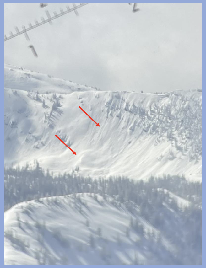
Most likely occurring early Wednesday morning when 4" of snow stacked up in about an hour, our man with the avy forecast plan, Trevor Katz, spotted this slide yesterday on a steep, wind drifted slope in Gardner Fork.
Micheal J found similar evidence of a recent avy cycle in the Hoyt environs Wednesday.

For all Uinta observations and archived avalanche activity click HERE.
Ad
Avalanche Problem #1
Wind Drifted Snow
Type
Location
Likelihood
Size
Description
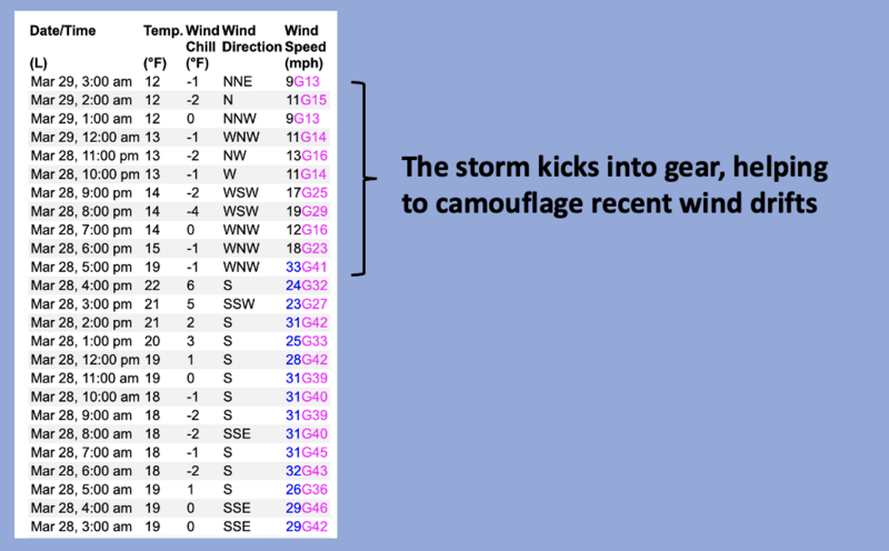
24 hour data dump from Windy Peak seen in the image above (10,662')
Yesterday's southerly winds cranked into the 40's and had no problem finding older scraps of loose snow to work with and began whipping up fresh drifts on the leeward side of upper elevation ridges and around terrain features like chutes and gullies, especially on slopes facing the north half of the compass. But of course, that was so yesterday, and with a switch in wind direction overnight along with some fresh storm snow to work with, the pattern is gonna be slightly more deceptive today as recent drifts are camouflaged by a fresh coat of white paint. And while today's drifts may not be big enough to roll you, they could easily catch you off guard, or boss you around in sustained, steep terrain. In any case, I think most of our problems are found around the dial, especially in the wind zone. You know the drill... lose the wind and you loose the problem and score a great day of riding to boot!
Additional Information
The Uinta weather station network was upgraded this summer and all that real-time info is found HERE. Simply click on "western Uinta" tab and then "weather stations" tab.

We are always looking for snow and avalanche observations or just general riding conditions. So... if you see something, say something. You can reach me directly at [email protected] or 801-231-2170.
Also, if you're looking for more avy education opportunities for yourself, your crew, or your club please don't hesitate to reach out to me and we'll find a presentation, class, or clinic for ya!
General Announcements

Issued at 03:30 on Friday, March 29th this forecast will be updated by 0700 Saturday, March 30th, 2024.
This forecast is from the U.S.D.A. Forest Service, which is solely responsible for its content. This forecast describes general avalanche conditions and local variations always occur.