Forecast for the Uintas Area Mountains

Craig Gordon
Issued by Craig Gordon for
Friday, April 7, 2023
It's a tale of two distinctly different avalanche dragons-
Cold snow on the polars where MODERATE avalanche hazard exits in the wind zone above treeline and a lingering wind drift or two reacts to our additional weight. Human triggered avalanches are POSSIBLE on steep wind drifted slopes, especially those facing the north half of the compass.
Hot pow on the solars as strong April sun and warming temperatures deliver damp snow on sunny slopes. The avalanche danger rises to MODERATE and human triggered avalanches are POSSIBLE especially during the heat of the day, on all steep, sun exposed, mid and low elevation slopes.
Remember, the sun is high in the sky and if you're feeling like an ant under a magnifying glass.... so is the snow- get out and get after it early before the sun beats you to the punch.

Low
Moderate
Considerable
High
Extreme
Learn how to read the forecast here
Special Announcements
My personal March Madness journey brought me to the Final Four of the avalanche forecast season and the shot clock is ticking the days off. I'll be wrapping up daily forecasts in three days, issuing my final avy forecast on Sunday April 9th. For me, it simply means I'll be taking a step back from snow and onto a sunny beach that leads me to my annual spring surf trip to Mexico :)
But don't let your heart be troubled... you'll still be able to tap into Uinta forecast info from the crew that Keeps You On Top of the Greatest Snow on Earth (we've got ya covered).
Weather and Snow
Nowcast- Clear skies offer a stunning morning with slightly warmer temperatures than yesterday at this time, currently registering in the low teens across the board. Southerly winds are light, blowing just 10-20 mph even near the high peaks. The snow took on heat yesterday and most slopes offer a thin heat crust and are slightly shrink-wrapped. But this is the time of year the Uinta's shine. On a go-anywhere base, upper elevation, wind sheltered, north facing terrain is the ticket where you'll still find cold, settled snow.
Forecast- Spring has sprung! Look for a stunning day with most sunny skies and temperatures climbing into the mid and upper 30's. Clouds drift into the region and southerly winds bump into the 30's late in the day as a weak storm crosses northern Utah tonight into Saturday morning.
Futurecast- Another weak impulse with little chance of precip crosses the area late Saturday into Sunday morning. Overnight low temperatures hover right around freezing Monday through midweek
Trip Reports-
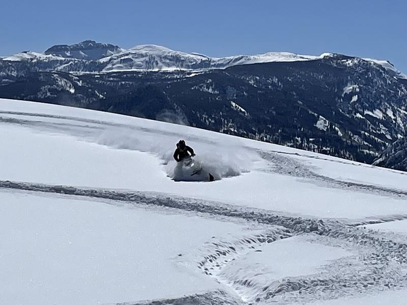
Trevor Katz in trenching mode in a big open meadow under the watchful eyes of Hayden Peak.
Joey and Westin D rallied around the Shingle Environs yesterday and have an insightful trip report found HERE.
Detailed trip reports and recent obs are found HERE.
Recent Avalanches
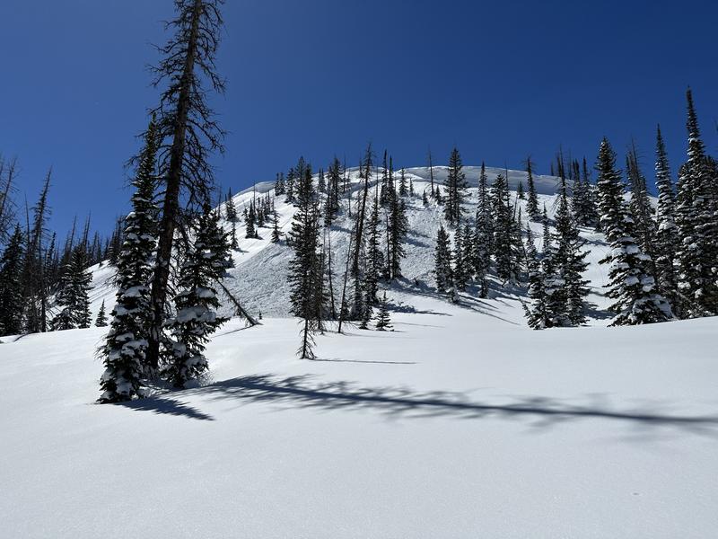
Inspired Summit Adventures business owner, guide, snow-pro, and most importantly mom-extraordinaire, Shaun Raskin, reports a natural avalanche yesterday on an ESE facing slope near Castle Peak. It looks like the 18" deep x 200' wide storm slab broke as the snow got warm and the slab became more connected with yesterdays strong sunshine and daytime heating.
No other significant avalanche activity to report, but there's plenty of avy activity to peruse if ya wanna geek out. Click HERE to track this years slide activity throughout the range.
Ad
Avalanche Problem #1
Wind Drifted Snow
Type
Location
Likelihood
Size
Description
Wind drifts like this one triggered yesterday in Upper Humpy Basin, aren't particularly widespread, but could offer an unwelcome surprise on steep, leeward slopes in the wind zone.
While the vast majority of our recent wind drifts have settled and are becoming comfortable in their own skin, I bet if you wanted to trigger an avalanche, there's a steep, upper elevation slope with your name on it. And remember... the there's an outside chance avalanches will break deeper and wider than you might expect, perhaps failing on a weaker layer or density inversion, now buried deeply in our snowpack. Now, here's where the rubber hits the road... once triggered, todays avalanches can easily boss you around. The good news is... there's plenty of terrain you can ride today and not have any issues. In fact, you can have a great day of riding by avoiding steep, wind drifted terrain and by steering clear of fat and rounded pieces of snow or slopes that sound hollow like a drum. Done, done, and done :)

Avalanche Problem #2
Wet Snow
Type
Location
Likelihood
Size
Description
The sun is high in the sky and it's penetrating all aspects and nearly all elevations, except for high north. Heads up... this weeks cold storm snow is gonna take a big gulp of vitamin D and it's gonna become reactive. As the cold snow takes on heat, you'll wanna consider getting off of and out from under steep, sun baked slopes, especially during the heat of the day.
Additional Information
Weather stations-
And... rime events from January's atmospheric rivers severely crippled the Uinta weather station network. I'm working to get it back up and running, but a few stations are found HERE (click weather stations, and then on the Western Uinta tab)
Observations-
Your observations are important, so please let me know what you're seeing... click HERE and contribute to this amazing community-based program
General Announcements
Issued at 03:23 on Friday April 7th this forecast expires 24 hours after the date and time posted, but will be updated by 07:00 Saturday April 8th 2023.
Before it gets too crazy, now is the time to book an avalanche awareness presentation for your group, club, or posse. You can reach Craig directly at 801-231-2170 or [email protected].

This forecast is from the U.S.D.A. Forest Service, which is solely responsible for its content. This forecast describes general avalanche conditions and local variations always occur.