Join us at our 2nd Annual Blizzard Ball

Forecast for the Uintas Area Mountains

Craig Gordon
Issued by Craig Gordon on
Tuesday morning, December 27, 2022
Expect increasing avy danger by late in the day as a warm, wet, high-octane storm sets its sights on the Uinta zone-
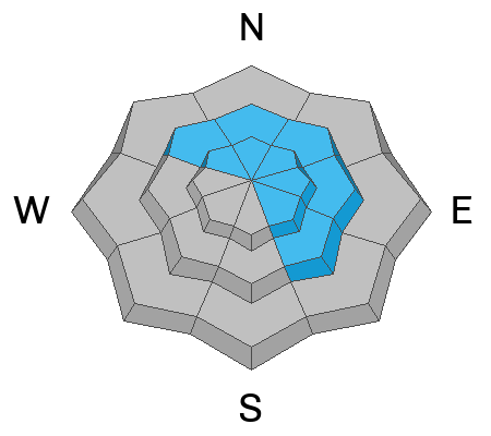
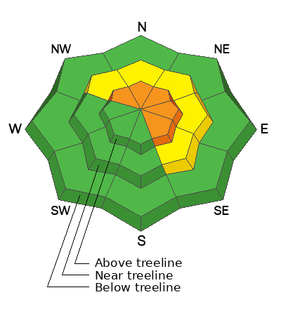
For this morning, you'll find pockets of CONSIDERABLE avalanche danger on steep, upper elevation, shady slopes. The danger is most pronounced in the wind zone at and above treeline, in terrain facing the north half of the compass, particularly on slopes with an easterly component to their aspect. Human triggered avalanches breaking to weak, sugary, midpack snow are LIKELY. Don't get surprised... mid elevation terrain is a player as well and you'll find MODERATE avalanche danger with human triggered avalanches POSSIBLE on steep, wind drifted slopes.
LOW avalanche danger is found on mid and low elevation wind sheltered terrain and slopes facing the south half of the compass with no overhead hazard (meaning, no steep slopes above or adjacent to where I'm traveling)
Low
Moderate
Considerable
High
Extreme
Learn how to read the forecast here
Special Announcements
Didn’t get what you want for Christmas? Do your loved ones simply give you money for the holidays and say “Go buy something for yourself?” Support the UAC and get a great gift for yourself or your loved one at our Holiday Auction. The auction closes at 8:00 PM MT on January 2, 2023

Weather and Snow
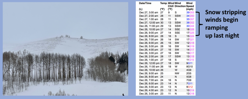
Nowcast- Thick clouds drape our mountains and it's downright tropical with temperatures registering in the upper 20's and low 30's. Southerly winds began rockin' the house after dinnertime Monday and continue in that spirit this morning with hourly averages in the 30's and gusts in the mid 50's near the high peaks. Riding and conditions are a bit hit or miss. However, on a go-anywhere Styrofoam base, wind sheltered terrain still offers soft, semi-creamy snow.
Forecast- Locked and loaded... a Winter Weather Advisory has been issued by our good friends and partners at the NWS as multi-day storm sets its sights on Utah. Temperatures peak in the mid 30's, southwest winds crank into the 60's, and snow slides into the area by late morning, intensifying for the drive home. Winds shift to the west and northwest as colder air settles into the region tonight and snow begins stacking up. A foot of snow by Wednesday morning is a good bet.
Futurecast- Snow continues through Wednesday, a break for Thursday, with another system hot on its heels to round out the work week.

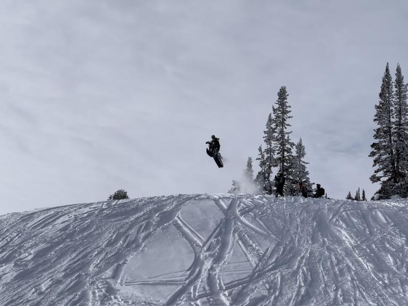
Ran into the @arvaequipment team yesterday and they were having a blast avoiding avy terrain and sending into next week like a boss... nice work men!
Lots of excellent trip reports and recent obs are found HERE.
Recent Avalanches
No new avalanche activity since Christmas Eve, but the writing is on the wall. Both human triggered and natural avalanches display similar characteristics, revealing a failure in the midpack weakness which leads to avalanches gouging to the ground.
Recent avy activity and a slew of Uinta obs are HERE.
Ad
Avalanche Problem #1
Persistent Weak Layer
Type
Location
Likelihood
Size
Description
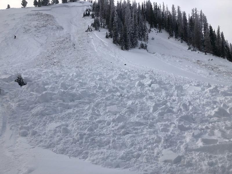
This slide triggered Saturday, tells me once we pull the rug out from underneath, we'll be staring down the barrel of a dangerous avalanche.
It's tricky... and here's why-
The snow feels strong and bomber under our skis, board, or sled. In fact, most slopes are generally good to go and happy in their own skin. Now here's the wild card... the most likely place to trigger an avalanche is where the snowpack is slightly shallower, like lower down on the slope. The tricky party here is that once you knock the legs out from underneath and the avalanche breaks to the weak midpack persistent weak layer, the entire roof is gonna crash down on top of us!
But wait... there's more-
Our deep, dangerous avalanche dragon is dormant for the moment, but it won't take much to bring the beast back to life. Found lurking on slopes facing the north half of the compass, especially those in the wind zone at and above treeline, by avoiding terrain with these characteristics, you essentially avoid the problem.

Avalanche Problem #2
Wind Drifted Snow
Type
Location
Likelihood
Size
Description
Recent winds nuke vast swaths of terrain facing the south half of the compass that was phat and white just a week ago.
If you went out wind drift hunting today, I bet you'd still find a rogue piece of snow that could react to your additional weight. In general though, these fat, rounded pillows of snow are welded in place. But don't let your guard down, today you'll wanna continue keying in on and avoid any fat looking piece of snow and avoid 'em, especially if they're sounding hollow like a drum.
Additional Information
Weather stations-
And... we were super busy this summer upgrading the western Uinta weather station network and this real-time winter info is found HERE (click weather stations, and then on the Western Uinta tab)
Observations-
Your observations are important, so please let me know what you're seeing... click HERE and contribute to this amazing community-based program
General Announcements
Issued at 03:57 on Tuesday December 27th, this forecast expires 24 hours after the date and time posted, but will be updated by 07:00 Wednesday December 28th.
Before it gets too crazy, now is the time to book an avalanche awareness presentation for your group, club, or posse. You can reach Craig directly at 801-231-2170 or [email protected].

This forecast is from the U.S.D.A. Forest Service, which is solely responsible for its content. This forecast describes general avalanche conditions and local variations always occur.