


Forecast for the Uintas Area Mountains

Issued by Craig Gordon on
Friday morning, December 2, 2022
Friday morning, December 2, 2022
Heads up.... today's storm is rapidly changing the landscape and the avy danger. Any avalanche triggered today has the distinct possibility of instantly ruining your day-
Look for HIGH avalanche danger on all steep, upper elevation slopes, especially those facing the north half of the compass, where strong winds continue forming fresh wind drifts atop weak faceted snow underneath. Both human triggered and natural avalanches are VERY LIKELY. In addition, winds have made their way into mid elevation terrain where you'll find a CONSIDERABLE avalanche danger and human triggered avalanches are likely. Even low elevation terrain is getting into the mix and you could get surprised on a steep slope right near the trailhead.
MODERATE avalanche danger is found on low and mid elevation south facing slopes and human triggered avalanches are possible.
Here's your exit strategy... find a mellow, low angle south facing slope or big open meadow with no steep slopes above or adjacent to where you're traveling and practice your riding skills like carving deep trenches in fresh snow. Remember, don't get too throttle happy because it's still low tide and there's plenty of reef barely hidden underneath our recent storm snow. With a significant danger of hitting rocks, stumps, and other obstacles, you'll wanna tone it down today and don't let a buried treasure ruin your season.
Low
Moderate
Considerable
High
Extreme
Learn how to read the forecast here
Avalanche Warning
Widespread avalanche activity is expected and the avalanche danger is HIGH. In fact, an AVALANCHE WARNING for the mountains of Northern Utah including the Wasatch Range, Bear River Range, and Western Uinta Range is in effect this morning until 6 a.m. MST Saturday. A rapid load of heavy snow combined with very strong winds and pre-existing weaknesses in the snowpack create very dangerous avalanche conditions. Both human triggered and natural avalanches are likely. Today you'll want to stay off of and out from under slopes steeper than 30 degrees.
 Special Announcements
Join the Utah Avalanche Center and the Division of Outdoor Recreation to celebrate the Fourth Annual Avalanche Awareness week, from December 4 - December 11. Click HERE to view the full list of events for the week.
Mirror Lake Highway is closed for the season. SR-35 (Wolf Creek Pass) remains open.
 Weather and Snow
Nowcast- The storm slid into the region around 8:00 last night and most locations report an inch or two of snow, but a backdoor sneak delivers nearly 5" of snow with .50" ish H2O to the Bald Mountain area. South and southwest winds haven't discriminated and are punishing the ridges, blowing 30-50 mph with gusts in the 70's along the high peaks. Under mostly cloudy skies, snow intensities are beginning to ramp up and temperatures register in the upper teens and low 20's.
Forecast- Snow continues for a couple more hours and we should see additional accumulations in the 6"-10" range. Temperatures don't vary much from where we're at this morning. Winds shift to the west and northwest by about sunrise and taper into the 20's and 30's. Under clearing skies, overnight low temperatures crater into the single digits.
Futurecast- A break in the action is slated for early Saturday, but another storm is hot on its heels and slated to develop late in the day.
 Recent Avalanches
It's been active on the eastern front with multiple avalanches reported on Wednesday.
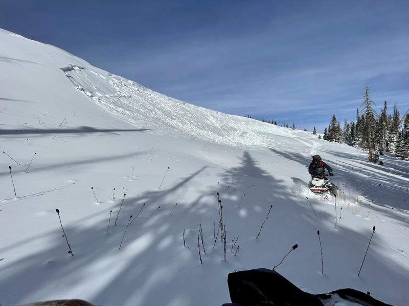
Common themes here are... avalanches triggered from a distance, breaking 12"-24" deep, failing on weak faceted snow formed during the late November dryspell. More deets found HERE.

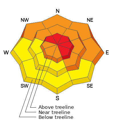
Avalanche Problem #1
Wind Drifted Snow
Type
Location
Likelihood
Size
Description
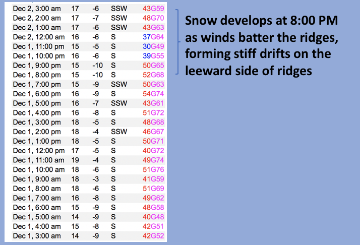
You don't need a weatherman to know which way the wind blows... but a well placed anemometer is certainly a bonus :) Above is a 24 hour data dump form Lofty Lake Peak (11,186')
South and southwest winds crank at mid and upper elevations, easily whipping new snow into stiff, hard drifts. Remember- hard, dense snow can give us a false sense of snow stability, allowing us to travel further out onto a slope before it fails and brings the entire roof down on top of us. Found mostly on the leeward side of upper elevation ridges, due to the strength and duration of winds, I'd also be on the lookout for fresh drifts around terrain features like chutes and gullies. In either case, both new and older drifts now rest on weak, faceted, older snow and that means avalanches are gonna be easy to trigger.
Obvious signs of unstable snow include cracking, collapsing, and whoomping noises as well as natures freebie... natural avalanches!
Video of widespread cracking along the Mirror Lake High near Bald Mountain. Find full observation HERE.
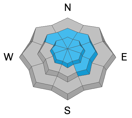
Avalanche Problem #2
Persistent Weak Layer
Type
Location
Likelihood
Size
Description
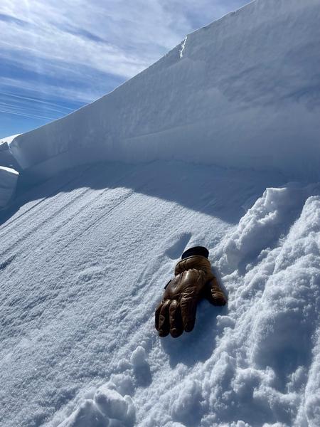
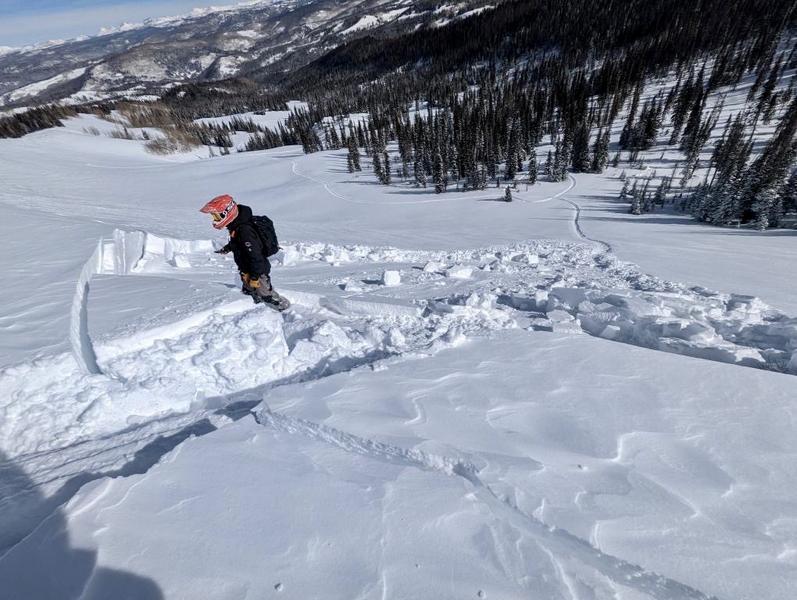
Weak, sugary, faceted snow formed during the November dryspell are clearly defined on the bed surface in the image above.
More info HERE.
Other than steep, south facing terrain, nearly all slopes, especially those facing the north half of the compass, exhibit varying depths of contiguous snow. The bad news is... two weeks of dry, cold weather during mid November, turbo charged the faceting process, creating a layer of weak, sugary facets on the snow surface. Prior to last Tuesdays big storm, the weakest snow was found on shady slopes, but is now camouflaged by several rounds of storm snow, making it hard to detect.
Here's where the rubber hits the road and what makes things tricky right now... weak faceted snow is our new problem child with the unruly characteristics of a persistent weak layer (PWL) and it's struggling to adjust to our latest round of snow, water, and wind.
The most significant and most dangerous avalanche dragon is found on mid and upper elevation slopes facing the north half of the compass. Wind sheltered terrain isn't immune to human triggered avalanches, but slides will be smaller, pockety in nature, and not as well connected.
Additional Information
And we've been super busy this summer upgrading the western Uinta weather station network and this real-time info is found HERE (click weather stations, and then on the Western Uinta tab)
Your observations are important, so please let me know what you're seeing... click HERE and contribute to this amazing community-based program
General Announcements
Issued at 03:30 on Friday December 2nd, this forecast expires 24 hours after the date and time posted, but will be updated by 07:00 Saturday December 3rd.
Before it gets too crazy, now is the time to book an avalanche awareness presentation for your group, club, or posse. You can reach Craig directly at 801-231-2170 or [email protected].
This forecast is from the U.S.D.A. Forest Service, which is solely responsible for its content. This forecast describes general avalanche conditions and local variations always occur.