Forecast for the Uintas Area Mountains

Nikki Champion
Issued by Nikki Champion for
Thursday, December 1, 2022
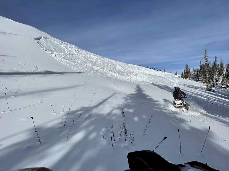
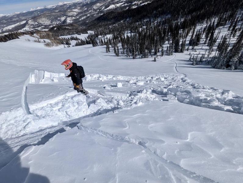
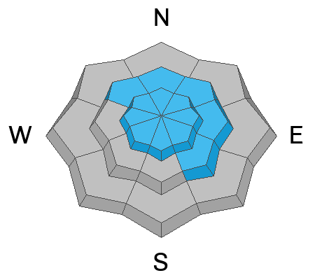
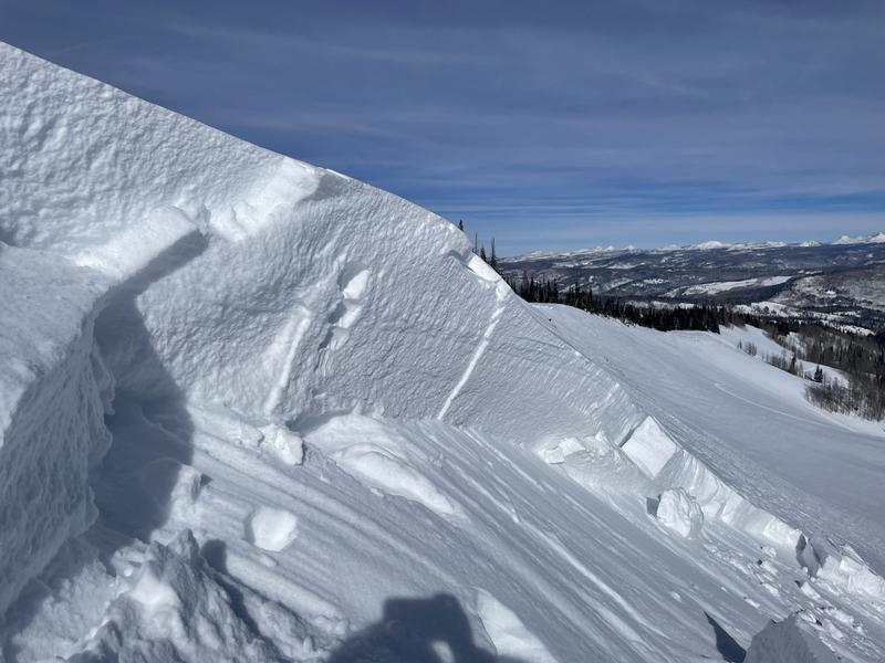
The avalanche danger is CONSIDERABLE on all upper-elevation slopes where strong winds continue to form fresh wind drifts atop weak faceted snow underneath. Human-triggered avalanches are likely and natural avalanches are possible. There is a MODERATE danger on mid-elevation slopes that got overall less wind and less snow. Evaluate snow and terrain carefully, and identify any features of concern.
Heads up: With another significant storm slated to begin this evening, avalanche danger will rise rapidly with heavy snowfall and strong winds.
There is still a significant danger of hitting rocks, stumps, and other obstacles. These hazards will be hard to see, but they will be easy to hit as they have become covered with new snow. Go slow and be careful.
Low
Moderate
Considerable
High
Extreme
Learn how to read the forecast here
Avalanche Warning
Widespread avalanche activity is expected and the avalanche danger will be HIGH. In effect from 3 p.m. MST this afternoon until 6 a.m. MST Saturday. For the mountains of Northern Utah including the Wasatch Range, Bear River Range, and Western Uinta Range. A rapid load of heavy snow combined with very strong winds and preexisting weaknesses in the snowpack will create very dangerous avalanche conditions. Both human triggered and natural avalanches are likely. Stay off of and out from under slopes steeper than 30 degrees.
Special Announcements
Join the Utah Avalanche Center and the Division of Outdoor Recreation to celebrate the Fourth Annual Avalanche Awareness week, from December 4 - December 11. Click HERE to view the full list of events for the week.

Mirror Lake Highway is closed for the season. SR-35 (Wolf Creek Pass) remains open.
Weather and Snow
This morning, things have begun to warm up and mountain temperatures have climbed into the mid-teens and low 20s F. Winds have transitioned to Southerly and are averaging speeds between 30-50 mph, with some gusts near 70 mph.
Today, temperatures will climb into the low and mid-20s F, and winds will remain southerly and continue to average 30-50 mph with occasional gusts between 75-80 mph.
Tonight, a potent storm arriving on strong southwesterly flow will bring a cold front through the region around 2-4 AM on Friday morning. SW winds will peak pre-frontal on Thursday night. Initially. dense snow with high PI will transition to lighter-density snow on NW flow behind the cold front. 10-15" of new snow is possible by tomorrow morning.

Backcountry travel remains generally easy and riding conditions are pretty good for mid-November. Any wind and sun-damaged slopes have now been covered with 5-12" of soft, low-density snow.
Recent Avalanches
Yesterday, multiple small avalanches were reported from the Western Uintas range. These avalanches were widespread on aspects facing SE through N at upper elevation. Almost all avalanches were failing as soft slabs of wind drifted snow on faceted grains between 10"-2' in depth.
Soft slab of wind drifted snow failing 12" on faceted grains - E Aspect - 9900' - Sandstone Basin Zone (Nassetta, Manship, Deutschlander)
Soft slab of wind drifted snow failing 2' deep on faceted grains - E aspect - 10,000' - Shingle Millow (Nassetta, Manship, Deutschlander)
Ad
Avalanche Problem #1
Wind Drifted Snow
Type
Location
Likelihood
Size
Description
Winds are cranking at upper elevations and only supposed to increase throughout the day. These elevated winds will continue to transport soft snow into much thicker drifts at mid and upper elevations.
These wind drifts will be generally isolated to terrain features that allow for drifting new snow to accumulate, such as ridges, sub-ridges, and gullies. Although the winds have been mainly from the south/southwest, winds this strong can channel snow around terrain features and create fresh drifts on all aspects, including well-down off of ridge lines. These wind slabs are resting on weak, faceted, old snow that will make them easy to trigger.
As the winds continue to blow, these slabs will become more firm and more cohesive. This can allow you to travel out farther onto the slope before it breaks, can fail larger than expected, and can enable the slope triggered remotely from any connected slope. Approach each new drift with caution.
Look for obvious signs of wind-drifted snow, such as pillow-shaped slopes, cracking, and whumpfing, and avoid those slopes. Avoid the wind zone, and avoid most of the problem today.
Video of widespread cracking along the Mirror Lake High near Bald Mountain. Find full observation HERE.
Avalanche Problem #2
Persistent Weak Layer
Type
Location
Likelihood
Size
Description
Prior to the most recent, storm, almost all slopes were snow-covered. The exception is steep, direct south-facing slopes which only had only a few inches of snow. All other slopes have varying depths but are well covered. Two weeks of dry and cold weather during November caused almost all slopes (except steep, direct south-facing) to form facets from the top to the bottom of the snowpack. The absolute weakest snow was on the surface on north-facing slopes. This weak faceted snow is now acting as a persistent weak layer (PWL) that has been capped by the past weekend's snow, and has been loaded by the most recent storm which created has a soft slab of snow on top of it.
The most significant and most dangerous avalanches will be on wind-loaded slopes because the slab of snow on top of this weak layer is more cohesive and thicker. In areas not loaded by the winds, avalanches remain possible, but these slides will be smaller and not break over such wide areas. Today's high winds and warmer temperatures should help consolidate the new snow, allowing it to become a more cohesive slab.
In wind-protected zones, the surface hoar from the two weeks of dry weather has been preserved and capped and could lead to increased sensitivity with any new snow.
Due to this, conditions will become much more dangerous with strong winds and more snowfall over the next few days.
Photo of wind drifted snow failing on weak faceted grains near the Duchensne Ridge(Nassetta, Manship, Duetchlander). Find full observation HERE.
Additional Information
And we've been super busy this summer upgrading the western Uinta weather station network and this real-time info is found HERE (click weather stations, and then on the Western Uinta tab)
Your observations are important, so please let me know what you're seeing... click HERE and contribute to this amazing community-based program
General Announcements
Before it gets too crazy, now is the time to book an avalanche awareness presentation for your group, club, or posse. You can reach Craig directly at 801-231-2170 or [email protected].

This forecast is from the U.S.D.A. Forest Service, which is solely responsible for its content. This forecast describes general avalanche conditions and local variations always occur.