Forecast for the Uintas Area Mountains

Nikki Champion
Issued by Nikki Champion for
Wednesday, November 30, 2022
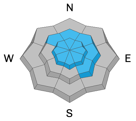
The avalanche danger is CONSIDERABLE on all upper-elevation slopes where fresh wind drifts are sitting atop weak faceted snow underneath. Human-triggered avalanches are likely and natural avalanches are possible. There is a MODERATE danger on low and mid-elevation slopes that got overall less wind and less snow. Evaluate snow and terrain carefully, and identify any features of concern.

There is still a significant danger of hitting rocks, stumps, and other obstacles. These hazards will be hard to see, but they will be easy to hit as they become covered with new snow. Go slow and be careful.
Low
Moderate
Considerable
High
Extreme
Learn how to read the forecast here
Special Announcements
Join the Utah Avalanche Center and the Division of Outdoor Recreation to celebrate the Fourth Annual Avalanche Awareness week, from December 4 - December 11. Click HERE to view the full list of events for the week.

Mirror Lake Highway is closed for the season. SR-35 (Wolf Creek Pass) remains open.
Weather and Snow
Final storm totals for the Western Uinta Mountains: 5-12" snow.
This morning, things have begun to warm up and mountain temperatures have climbed into the mid-teens and low 20s F. Winds have transitioned to Southwesterly and averaged 10-20 mph, with some gusts near 40 mph.
Today, the skies will start clearing throughout the day. Temperatures will climb into the low and mid-20s F, and winds will become more southeasterly averaging 10-20 mph with occasional gusts between 30-40 mph.
This active pattern continues, with increasing southwest flow Thursday ahead of the next round of snow around the Friday timeframe.

Backcountry travel remains generally easy and riding conditions are pretty good for mid-November. Any wind and sun-damaged slopes have now been covered with 5-12" of soft, low-density snow.
A few key takeaways for the Western Uintas from before the storm:
  • Almost all slopes were snow-covered. The exception is steep, direct south-facing slopes which only have a few inches of snow. All other slopes have varying depths but are well covered.
  • Almost all slopes (except steep, direct south-facing) have lots of facets from top to bottom of the snowpack. The absolute weakest snow is on the surface on the north facing.
  • In wind-protected zones, the surface hoar from the two weeks of dry weather has been preserved and capped, and could lead to increased sensitivity.
Due to this, conditions will become much more dangerous with strong winds and more snowfall over the next few days.

Folks have been getting out, and looking at terrain find their insightful observations and trip reports are found HERE.
Recent Avalanches
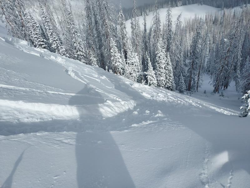
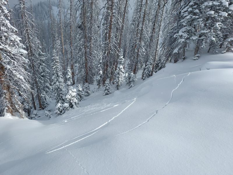
Yesterday, Michael J was able to trigger two avalanches from the Hoyt Peak Zone. The first is an intentionally triggered avalanche on a North Aspect at 10,000'. This avalanche failed below the new snow, on the weak facets from before the storm. It broke 12" deep, and ran 250' and 175' wide. The second avalanche reported was remotely triggered while skinning back up to the crown. Michael also reported widespread cracking and collapsing. Find the full observation HERE.
Photo from the intentionally triggered avalanche.
Photo of the remotely triggered avalanche
Ad
Avalanche Problem #1
Wind Drifted Snow
Type
Location
Likelihood
Size
Description
Over the last 24 hours, winds have remained elevated, with gusts between 30-40 mph. These elevated winds will continue to transport the 5-12" of new snow into much thicker drifts at mid and upper elevations.
These wind drifts will be generally isolated to terrain features that allow for drifting new snow to accumulate, such as ridges, sub-ridges, and gullies. Although the winds have been mainly from the west/southwest, winds this strong can channel snow around terrain features and create fresh drifts on all aspects, including well-down off of ridge lines. As these wind slabs form they will be resting on weak, faceted, old snow that will make them easy to trigger.
As the winds continue to blow, these slabs will become more firm and cohesive. This can allow you to travel out farther onto the slope before it breaks, and can fail larger and wider than expected. Approach each new drift with caution.
Look for obvious signs of wind-drifted snow, such as pillow-shaped slopes, cracking, and whumpfing, and avoid those slopes
Avalanche Problem #2
New Snow
Type
Location
Likelihood
Size
Description
The Uinta Mountains have already received 5-12" of new snow since the 28th. In areas protected from the wind, you might still be able to find an avalanche within the new snow. This includes both long-running sluffs and sensitive soft slabs.
The slopes that we will want to ride, are the slopes that held any snow before this storm system. The issue is, these slopes are exactly the ones where the snow has become weak and faceted, and the new snow likely won’t bond well too, and could cause an avalanche to fail deeply and be triggered remotely.
Heads up: In these wind-protected zones, the surface hoar from the two weeks of dry weather has been preserved and capped, and could lead to increased sensitivity of the new snow.
Additional Information
And we've been super busy this summer upgrading the western Uinta weather station network and this real-time info is found HERE (click weather stations, and then on the Western Uinta tab)
Your observations are important, so please let me know what you're seeing... click HERE and contribute to this amazing community-based program
General Announcements
Before it gets too crazy, now is the time to book an avalanche awareness presentation for your group, club, or posse. You can reach Craig directly at 801-231-2170 or [email protected].

This forecast is from the U.S.D.A. Forest Service, which is solely responsible for its content. This forecast describes general avalanche conditions and local variations always occur.