Check out our Holiday Auction - Sign Up for the Utah Snow and Avalanche Workshop (USAW)

Forecast for the Salt Lake Area Mountains

Drew Hardesty
Issued by Drew Hardesty on
Saturday morning, December 18, 2021
TODAY HAS ACCIDENT WRITTEN ALL OVER IT.
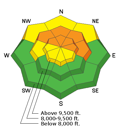
THE AVALANCHE DANGER IS CONSIDERABLE. Human triggered avalanches 2-4' deep and hundreds of feet wide are likely on steep northwest through east facing slopes at the mid and upper elevations. Avalanches can be triggered from a distance, even hundreds of feet away. It's also possible to trigger wind drifts and loose new snow avalanches in the upper elevation bands.
THE GOOD NEWS: Low angle terrain and southerly facing terrain has fantastic skiing and riding.
Low
Moderate
Considerable
High
Extreme
Learn how to read the forecast here
Weather and Snow
It's the stuff that dreams are made of.
The Wasatch picked up another 5-7" of cold smoke yesterday, pushing rough storm totals to 30-40" since late Tuesday. We finally have some snow on the ground with snow depths now pushing 4-6'+ in the higher elevations.
Skies are clear with light wind from the west northwest. Temps are in the single digits.
For today, we'll have clear skies, light westerly wind and temperatures warming to the 20s. (see first line of the forecast above)
Tomorrow will be similar to today with continued warming temperatures. (Sunscreen and skin wax advised)
The next series of storms are forecast to barrel through mid/late week. Stay tuned.
Greg's excellent Week in Review can be found HERE.
Recent Avalanches
Another SEVEN human triggered avalanches reported from the backcountry, including one full burial in the Meadow Chutes of Silver Fork in BCC. He was the third skier on the slope, washed through trees and found that he was luckily able to thrust his hand up to create an air-hole to breathe. His partners climbed up from below to dig him out. The report is HERE, the video is below. Thanks to the party for sharing this information.

The other avalanches from yesterday were all triggered at a distance. Some were triggered from a thousand yards away.
  • Cardiff Fork - 9000' North facing 2.5' deep x 150' wide
  • Sheepshit Ridge - 9400' NE facing 3' deep x 1500' wide
  • Sheepshit Ridge - 9000' North facing 2.5' deep x 150' wide
  • Honeycomb - 10,400' North facing 4' deep x 150' wide (Forecaster Note: a skier remotely triggered a cornice which then triggered the avalanche below - these avalanches unfortunately will threaten Solitude terrain below and should be given a wide berth if possible)
  • Wilson Fork: 9100' East facing 18 deep"x 100' wide
  • Wilson Headwall: 9400' North facing 2.5' deep and 350' wide
All of these reports with photos/videos, etc can be found under Observations and Avalanches in the menu above.
(Uncertain about locations? Check out the Wasatch Backcountry Skiing map or download the app on your smartphone.)
Ad
Avalanche Problem #1
Persistent Weak Layer
Type
Location
Likelihood
Size
Description
There is no secret here. There is no mystery. You simply have to avoid steep terrain on the shady side of the compass. We're seeing avalanches, experiencing shooting cracks and feeling audible whumphs. There is no mystery here.
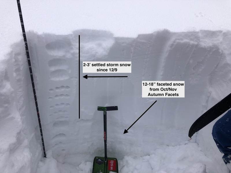
The BOTTOM LINE is that dangerous avalanche conditions exist on mid and upper elevation slopes facing northwest through east where 2-3' of storm snow and wind-blown snow over the past 9 days have overloaded weak, faceted snow (a persistent weak layer, or PWL) in the bottom of the snowpack. Avalanches may break down 2-3' deep (possibly deeper) and propagate hundreds of feet wide. The photo below illustrates this structure:
My own touring party remotely triggered two avalanches yesterday from the safety of the ridge above the Wilson headwall of the BCC/MCC ridgeline.
FORTUNATELY THE TRAVEL ADVICE IS SIMPLE:
  1. IF you want to ride terrain on the northerly side of the compass, you must choose low angle terrain with no overhead hazard. (You might trigger the avalanche on top of yourself.)
  2. Ride terrain that does not harbor the old October faceted grains that we call PWL (persistent weak layer). The GOOD NEWS is that the riding conditions on southwest to south to southeast facing slopes are EXCELLENT.
Additional Information
Greg shared a few quotes from Thursday -
"Cranky snowpack this year." - Peter Donner in his Thursday observation from Main Porter. No one knows Millcreek Canyon better than Peter.
"Never seen that area break ever in my life.... buried above the waist, over an hour to self evacuate... caught on far side very close to full burial" - From solo skier caught in Hidden Canyon avalanche on Wednesday.
The quote that influenced me the most is from Dave Richards - director of the avalanche program at Alta and one of the most-respected snow safety professionals anywhere. Dave texted me last night, "Beg them to be careful."
General Announcements

This information does not apply to developed ski areas or highways where avalanche control is normally done. This forecast is from the U.S.D.A. Forest Service, which is solely responsible for its content. This forecast describes general avalanche conditions and local variations always occur.