Check out our Holiday Auction - Sign Up for the Utah Snow and Avalanche Workshop (USAW)

Forecast for the Salt Lake Area Mountains

Drew Hardesty
Issued by Drew Hardesty on
Sunday morning, December 19, 2021
THE AVALANCHE DANGER IS CONSIDERABLE.
Most accidents and fatalities are during CONSIDERABLE danger.
Human triggered avalanches 2-5' deep and hundreds of feet wide are likely on steep westerly to northerly to east facing slopes at the mid and upper elevations. Avalanches can be triggered from a distance, even hundreds of feet away. It's also possible to trigger fresh wind drifts this morning and shallow wet snow avalanches by the afternoon.
THE BAD NEWS: I am afraid our luck will run out today. Consider who actually assumes the risk?
THE GOOD NEWS: Low angle terrain and southerly facing terrain has fantastic skiing and riding.
Low
Moderate
Considerable
High
Extreme
Learn how to read the forecast here
Special Announcements
Deer Valley resort will be conducting operations in the Empire area today. Please avoid this terrain for today. Thank you.
Weather and Snow
Skies are clear.
With a building inversion, mountain temperatures are in the mid-20s while trailheads and basins are mired in the single digits.
Westerly winds picked up a touch along the ridgelines and are blowing 15-20mph. 11,000' anemometers are averaging 25-30mph with gusts to 45.
Riding conditions remain excellent, although many southerly and westerly aspects will have a zipper crust this morning before the mid-day thaw.
For today, we'll have mostly sunny skies, light to moderate westerly winds and temperatures soaring to low 30s up high and the upper 30s down low.
Sunscreen and skin wax are recommended.
Looking down the road, we'll have pleasant weather for the first part of the week before a series of storms impact the state Wednesday night into beyond.
Greg's excellent Week in Review can be found HERE.
Recent Avalanches
It's really too much. We had another dozen reported human triggered avalanches in the backcountry with at least four people taking rides in avalanches. There were many close calls.
My phone rang at 930am telling of the first avalanche in Two Dogs of Upper Days Fork where a skier was caught and carried, deployed his airbag and ended up on top of the debris.
It didn't stop ringing until evening.
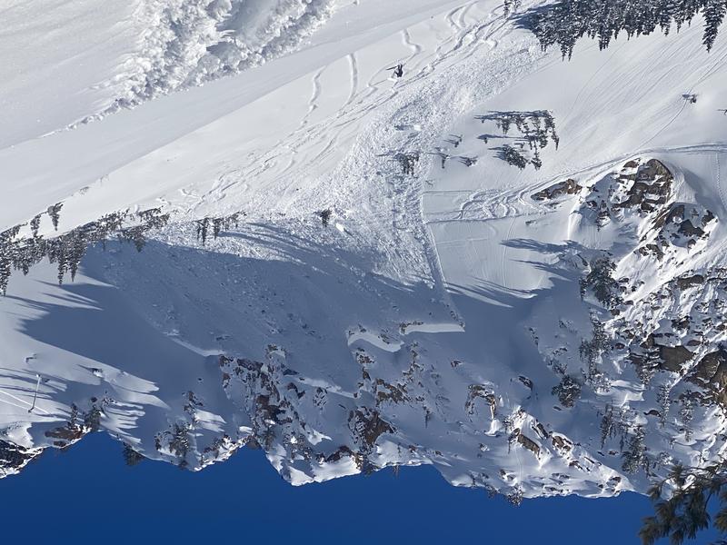
Two avalanches - Cardiff Bowl above the town of Alta (photo below) and the Tri-Chutes (of White Pine) nearly involved multiple parties in and below the avalanche.
HEAT MAP OF RECENT AVALANCHES SINCE DEC 10TH
All of these reports with photos/videos, etc can be found under Observations and Avalanches in the menu above.
(Uncertain about locations? Check out the Wasatch Backcountry Skiing map or download the app on your smartphone.)
Ad
Avalanche Problem #1
Persistent Weak Layer
Type
Location
Likelihood
Size
Description
There is no secret here. There is no mystery. You simply have to avoid steep terrain on the shady side of the compass. We're seeing avalanches, experiencing shooting cracks and feeling audible whumphs. There is no mystery here.
The BOTTOM LINE is that dangerous avalanche conditions exist on mid and upper elevation slopes facing northwest through east where 2-3' of storm snow and wind-blown snow over the past 9 days have overloaded weak, faceted snow (a persistent weak layer, or PWL) in the bottom of the snowpack. Avalanches may break down 2-3' deep (possibly deeper) and propagate hundreds of feet wide.
FORTUNATELY THE TRAVEL ADVICE IS SIMPLE:
  1. IF you want to ride terrain on the northerly side of the compass, you must choose low angle terrain with no overhead hazard. (You might trigger the avalanche on top of yourself.)
  2. Ride terrain that does not harbor the old October faceted grains that we call PWL (persistent weak layer). The GOOD NEWS is that the riding conditions on southwest to south to southeast facing slopes are EXCELLENT.
Avalanche Problem #2
Wind Drifted Snow
Type
Location
Likelihood
Size
Description
Increasing southwesterly winds overnight have drifted the recent storm snow into soft pillowy slabs of wind blown snow. They will be reactive to the weight of a skier or rider on the slope and may be more sensitive than you think. These drifts may be up to 12" deep or so and more pronounced just lee of the ridgelines on slopes facing west to north to southeast. Some mid-elevation exposed ridgelines may be prone to wind drifting as well.
Additional Information
If you trigger or see an avalanche adjacent to the road or one of the ski areas and are sure no one was caught in the avalanche, call the nearest mountain dispatch and alert them to the situation, this will allow SAR teams to stand down, preventing them from being subjected to unnecessary hazard.
Salt Lake and Park City – Alta Central (801-742-2033)
Canyons Resort/PCMR Dispatch (435 -615-1911)
Snowbasin Resort Dispatch (801-620-1017)
Powder Mountain Dispatch (801-745-3772 x 123).
Sundance Dispatch (801-223-4150)
General Announcements

This information does not apply to developed ski areas or highways where avalanche control is normally done. This forecast is from the U.S.D.A. Forest Service, which is solely responsible for its content. This forecast describes general avalanche conditions and local variations always occur.