March Kicks Off Our Spring Campaign- Donate Now to Support Forecasting

Forecast for the Uintas Area Mountains

Craig Gordon
Issued by Craig Gordon on
Friday morning, March 5, 2021
Today you'll find MODERATE avalanche danger above treeline in upper elevation terrain, especially in the wind zone. While more the exception than the rule, human triggered avalanches breaking into old snow near the ground are POSSIBLE, particularly on steep, wind drifted slopes facing the north half of the compass and especially in terrain with an easterly component to its aspect. Remember- any avalanche that breaks to weak layers of snow near the ground will result in a deep, dangerous avalanche that'll instantly ruin your day.

Steep, sunny terrain at all elevations takes on heat today and the danger for wet slides and sluffs rises to MODERATE with daytime heating. Human triggered wet snow avalanches are POSSIBLE during the heat of the day.
Low
Moderate
Considerable
High
Extreme
Learn how to read the forecast here
Special Announcements
Test your avalanche forecast comprehension skills by taking this short quiz after you read the forecast. Click HERE.
Go here to learn why we are asking you to take this quiz
Weather and Snow
Nowcast-
In the wake of yesterday's mighty storm that produced about an inch of snow, skies cleared, temperatures dipped into the mid teens and low 20's, and northerly winds blow 10-20 mph along the ridges. On the south half of the range, northerly winds are slightly stronger, blowing to 30 mph along the high peaks. In between the old tracks and developing crusts, soft settled snow is found on wind sheltered, shady slopes.
Forecast-
Look for mostly sunny skies, light northerly winds, and temperatures soaring into the low 40's. Winds shift to the south and increase into the 30's and 40's as the day progresses.
Futurecast-
Sunny skies, warm temps, and continued strong winds are slated for Saturday as a dry cold front slides into the region Sunday. A more active pattern with potential for unsettled weather and snow materializes next week.

Looking for real-time temps, snow, or wind?
Click here and then on the "western Uinta" tab for western Uinta specific, weather station network.
Recent Avalanches
With perseverance and a little provocation prompted by a few pounds of Pentolite, PC Powder Cats pulled out a pencil hard P-slab... whilst throwing in a little alliteration to boot :)
Triggered earlier in the week, this slide discovered by Michael Davis and Chad Bracklesberg in Soapstone yesterday, shows how avalanches triggered from a distance are still possible. Not particularly large, but it dumps into a gully feature or terrain trap below which heightens its consequences. Check out their great ob HERE.

More obs, trip reports, and avalanches found here.
Ad
Avalanche Problem #1
Persistent Weak Layer
Type
Location
Likelihood
Size
Description
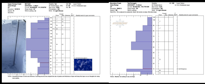
A tale of two snowpack structures. The left image and an excellent ob from Bill and Andy in Upper Humpy Basin represents a deep pack that's gaining strength and it would be difficulty to trigger a slide. The right image and an equally excellent ob from Ted on the east side of the range in Boundary Creek illustrates a thinner pack and the type of setup where we could still trigger a slide that breaks to old snow.
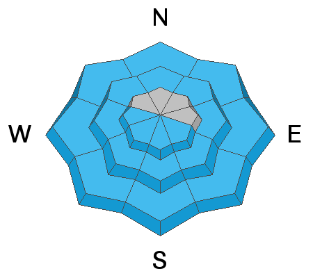
The Valentines storm is settling and gaining strength, as a matter of fact, getting around is seamless because the snow will feel solid under our skis, board, or sled... and that's good news. But it's a double edge sword and we need to think not only about the snow we're riding in, but also the snow we're riding on. And we need to remember most of our winter snowpack is resting on an early season persistent weak layer (PWL) or weak, sugary facets about a foot above the ground.... think strong snow on weak snow. The PWL exists on most slopes except those facing due south and southwest.
Avalanche conditions remain deceptively tricky and here's why-
The probability of triggering a deep dangerous avalanche is generally low, but the consequences are high because the entire seasons snowpack will crash down on top of you if you have misjudged the snowpacks stability. Now, you wouldn't go to Vegas and bet against the house with those odds right? Personally, I don't entirely trust anything in the snowpack I can't manage, so I'm going to continue avoiding terrain that harbors questionable snowpack structure. Of course the usual suspects come to mind... steep, rocky, upper elevation slopes facing the north half of the compass is bulls-eye terrain and should be considered suspect. With all the great coverage across the range and so many other riding options, there's no reason to roll the dice or pull on the dogs tail.
What to do? Unfortunately it's just a season with a dangerous snowpack. There's no way around that fact, and the key to longevity is avoiding big, open terrain, especially those in the Alpine that are steeper than about 30 degrees.
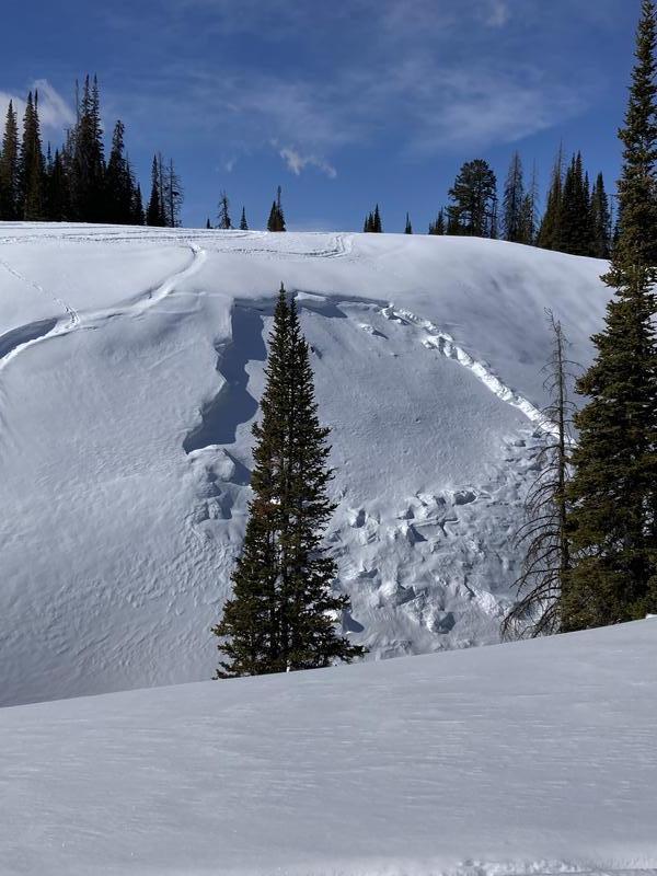
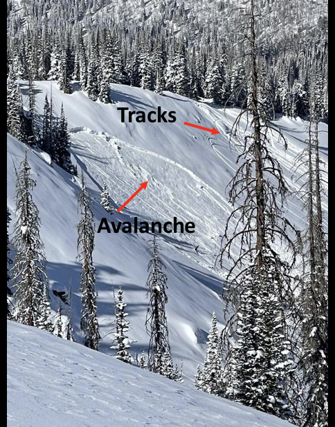
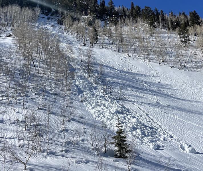
With such a supportable slab on top of the PWL, a slope may have many sets of tracks on it and still slide if someone hits a thin spot in the snowpack near a rock or bush hidden under the snow, like in the image above.
Avalanche Problem #2
Wet Snow
Type
Location
Likelihood
Size
Description
Damp snow dribbling off steep cliffs bands like in the image above is a good indicator that sunny slopes are heating up. Weston D found a good deal of both old and new wet activity Wednesday... his great insights to spring conditions are found here.
The sun is high in the sky and every slope expect for high north facing terrain will take on heat today. So, if you're feeling like an ant under a magnifying glass so is the snow. As the surface snow becomes damp, manky, or unsupportable you'll want to get off of and out from steep sun baked slopes, and steer clear of terrain traps like gullies where even a small avalanche can stack up deep piles of debris.
Additional Information
I will update this forecast by 7:00 AM tomorrow, Saturday, March 6th.
Your observations are important, so please let me know what you're seeing... click HERE and contribute to this amazing community based program
General Announcements
If you see or trigger an avalanche or just wanna let me know what you're seeing you can reach me directly at 801-231-2170 or [email protected]
This forecast is from the U.S.D.A. Forest Service, which is solely responsible for its content. This forecast describes general avalanche conditions and local variations always occur.