Join us at our 2nd Annual Blizzard Ball

Forecast for the Logan Area Mountains

Toby Weed
Issued by Toby Weed on
Wednesday morning, February 24, 2021
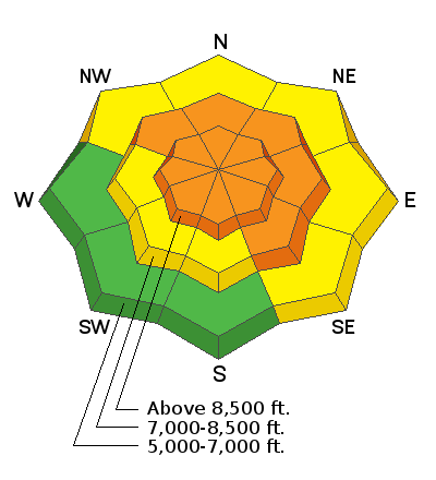
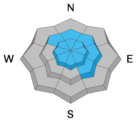
Conditions in the backcountry are still dangerous, and there is CONSIDERABLE danger on steep mid and upper elevation slopes. People are likely to trigger large avalanches failing 3 to 4 feet deep on a widespread buried persistent weak layer. The danger is higher on drifted upper elevation slopes facing northwest through southeast. Avalanches might be triggered remotely, or from a distance, and could be very large and dangerous.
People could trigger avalanches at any elevation, but you can find safer conditions in sheltered terrain, at lower elevations, and on gentle lower angled slopes.
  • Continue to use extreme caution in the backcountry.
  • Expect unstable snow conditions, even if obvious signs of instability are absent.
Low
Moderate
Considerable
High
Extreme
Learn how to read the forecast here
Special Announcements
We are very sad to report that on 2-20-2021, a 48-year-old Preston man was killed in an avalanche on the east side of Sherman Peak west of Georgetown Idaho. Our preliminary accident report is HERE.
Weather and Snow
Moderate snowfall is visible on the Beaver Mountain Webcams this morning and a few inches of light snow fell in the mountains overnight. There is a four inches of new snow with 0.3" SWE in the last 24 hours at the 8400' Tony Grove Snotel. It's 14°F, 13° cooler than yesterday morning, and there is 76 inches of total snow and 83% of normal SWE. Westerly winds moderated since yesterday, but are still blowing and drifting snow this morning at upper elevations. Winds from the west-northwest are blowing 15 to 20 mph at the CSI Logan Peak weather station. There has been a good deal of drifting at upper elevations from mostly west winds in the past several days. On many steep slopes, the drifting has added weight and stiffness to the existing slab that is capping widespread weak sugary snow. Some slopes now hang in a precarious balanced state, only needing a person ride by to trigger a dangerous avalanche.
We're expecting a cold and snowy day in the mountains, but not much in the way of accumulation. Temperatures at 8500' will top out at around 12°F, and moderate north winds will create wind chill values as low as -4°F. Cold temperatures will persist tomorrow, with increasing clouds. Snow is likely Thursday night and Friday, with 4 to 7 inches possible. Cold and unsettled weather will continue through the weekend and into next week.
Recent Avalanches
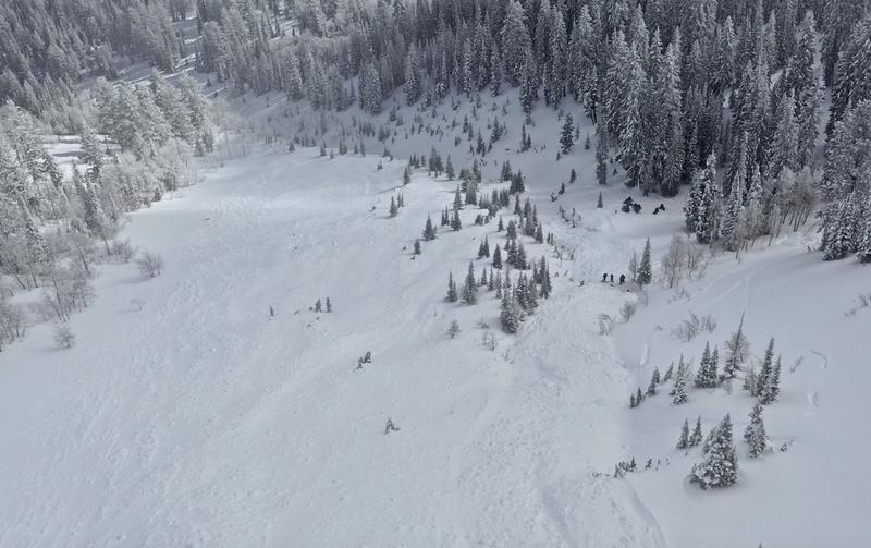
On Saturday 2-20-2021 a party of riders remotely triggered a very large avalanche near Gibson Lakes in Franklin Basin, a few miles north of the Idaho state line. The large group of riders were down in the flats, and well out from under any steep terrain when they heard a very loud "sonic boom" audible collapse, and the whole hill came down... clouds obscured the crown, but the debris field was quite broad.
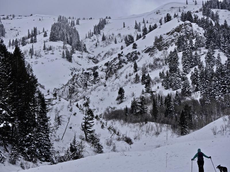
A significant natural cycle occurred across the Logan Zone early last week, with many huge avalanches observed. Very large natural avalanches failing on a buried sugary persistent weak layer and running well out into lower elevation runout zones were widespread and occurred on slopes facing every direction. Reports of extensive natural avalanches include most avalanche paths in the Wellsville Mountain and Mount Naomi Wildernesses, in Upper Spring Hollow, and Wood Camp Hollow. Big avalanches were also reported near Tony Grove Lake, Providence Canyon, Logan Dry Canyon, Cub River, Hillyard Canyon, and in the mountains west of Bear Lake.
A few natural avalanches also occurred over last weekend due to loading from blowing snow.
Large natural avalanches were widespread across the Logan Zone early last week.
Ad
Avalanche Problem #1
Persistent Weak Layer
Type
Location
Likelihood
Size
Description
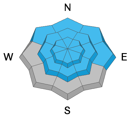
Heavy snowfall and westerly winds last week added significant weight to slopes that were already near the tipping point. Buried persistent weak layers consisting of sugary faceted snow are widespread across the Logan Zone, and the threat of large and deadly avalanches failing on weak snow near the ground is quite real. Avalanches are likely on steep slopes that did not naturally avalanche recently, where a slab of more cohesive wind drifted snow is building on top of the weak snow.
  • Avalanches failing on a buried persistent weak layer might be triggered remotely, from a distance, or worse from below!
  • Cracking and collapsing of the snow are a red flag, indicating unstable snow conditions.
Avalanche Problem #2
Wind Drifted Snow
Type
Location
Likelihood
Size
Description
Avalanches of wind drifted snow are likely where drifts formed recently, especially on slopes with buried persistent weak layers.
  • Wind slabs are often rounded and chalky looking, and they can sound and feel hollow and drum-like when you walk on them.
  • Watch for and avoid stiffer drifted snow near ridge tops and in and around terrain features like gullies, scoops, cliff bands, and sub ridges.
  • Stay well back from cornice edges as they can break much further back than you expect and avalanches are likely on slopes below.
Additional Information
Do you have the essential avalanche rescue gear (transceiver, probe, and shovel) and do you know how to use them? Watch this video to see how the three pieces of equipment work together. HERE
Please keep practicing with the Beacon Training Park at the Franklin Basin Trailhead. Test yourself and your riding partners. It is free, fun, and easy to use.
General Announcements
Visit this website with information about Responsible Winter Recreation by the Utah Office of Outdoor Recreation.
EMAIL ADVISORY. If you would like to get the daily advisory by email you subscribe HERE.
Remember your information can save lives. If you see anything we should know about, please help us out by submitting snow and avalanche observations....HERE. You can also call us at 801-524-5304, email by clicking HERE, or include #utavy in your tweet or Instagram.
I will update this forecast by around 7:30 tomorrow morning.
This forecast is from the USDA Forest Service, which is solely responsible for its content. The forecast describes general avalanche conditions and local variations always occur.