Forecast for the Salt Lake Area Mountains

Issued by Nikki Champion for
Thursday, December 12, 2019
Thursday, December 12, 2019
With increased snow and wind the avalanche danger will be on the rise.
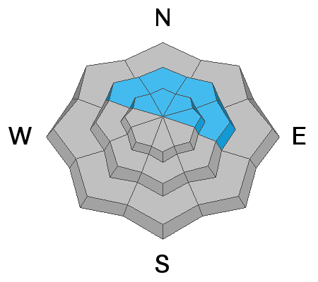
Today the avalanche danger is CONSIDERABLE on northerly and east-facing slopes at mid and upper elevations where a persistent weak layer of snow exists 2-4 feet deep. New snow and increased winds will only add stress to this layer making human triggered avalanches likely.
The avalanche danger is MODERATE on southerly-facing and west-facing slopes at mid and upper elevations which don't have the persistent weak layer on the ground. Winds will be increasing throughout the day, on these aspects watch for signs of developing slabs of wind drifted snow, and avoid them.
LOW avalanche danger exists at low elevations which continue to have generally safe avalanche conditions.

Low
Moderate
Considerable
High
Extreme
Learn how to read the forecast here