Forecast for the Salt Lake Area Mountains

Greg Gagne
Issued by Greg Gagne for
Monday, December 3, 2018
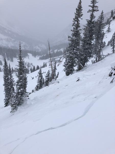
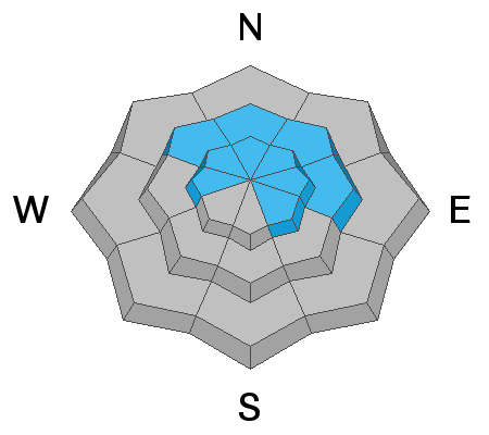
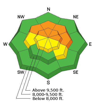
The avalanche danger is CONSIDERABLE on mid and upper elevation aspects facing northwest through north and east. Human triggered avalanches are LIKELY where you can expect avalanches to break 2-3' feet deep and over several hundred feet wide. Avalanches can be triggered from a distance, from below on lower-angled slopes, and on slopes that have already slid this year.
There are much safer riding alternatives on southerly aspects.

There is also a Moderate hazard for sluffing in the loose storm snow, as well as isolated pockets of fresh wind drifts on upper elevation aspects facing east and southeast.
Low
Moderate
Considerable
High
Extreme
Learn how to read the forecast here
Special Announcements
We have a couple of fun events coming up on December 5th and 6th in Salt Lake and Park City. Topics include Recreating in New Zones, Women's Specific Avalanche Awareness, and a slide show from Ascent Magazine. More info about these events HERE.
Weather and Snow
Mountain conditions this morning feature temperatures in the single digits with some of the warmer spots in the low teens. Winds are out of the west/northwest and generally light, less than 10 mph, although some stations along upper elevation ridgelines have recorded overnight gusts in the upper teens. The Salt Lake and Park City mountains squeezed out another 3-7" of 5% Wasatch fluff overnight, bringing 24-hour snow totals of 6-12". As is often the case with a northwest flow, upper Little Cottonwood fared best.
Snowpack depths in the Cottonwoods and along the Park City ridgeline range from 2-4', with even higher localized amounts in the upper Cottonwoods.
Perfect December weather continues today with mostly-cloudy skies and continued snow showers with mountain temperatures in the teens. The cold northwest flow may deliver another 2-4" of low-density snow during the day today, especially in favored locations such as upper Little Cottonwood. Winds will be out of the west/northwest and generally light, with gusts in the teens along the upper elevation ridgelines. Chance for continued snow showers overnight.
Recent Avalanches
Other than some minor sluffing in the loose storm snow, the only avalanche activity reported from Sunday was a remotely-triggered slide in Cardiff Fork shown in the photo below. This was on a northwest-facing aspect at 10,000' and 50' wide, likely running on weak faceted snow down near the ground.
Click here for an excellent field report from pro observer Andy Paradis and UAC executive director Chad Brackelsberg from the Park City mountains.
Ad
Avalanche Problem #1
Persistent Weak Layer
Type
Location
Likelihood
Size
Description
Since this past Wednesday, the Salt Lake mountains have received over 2' of storm snow with a significant wind loading event on Thursday. During this period, there were numerous human-triggered avalanches, many of which were triggered remotely (from a distance), as well as several large natural avalanches. Mitigation results from control work at resorts also produced large avalanches. Although winds have diminished, since Sunday nearly another 0.5" of water weight was added to the snowpack. Field observations from Sunday included another remotely-triggered avalanche, continued reports of collapsing, as well as full propagation with extended column tests, all indications the weak faceted snow that can be found on aspects facing west, through north, to east remains reactive. If you choose to ride a slope steeper than about 30 degrees on one of these aspects you are likely to trigger a large avalanche that will be 2-3' deep and may run several hundred feet wide. Hmmmm ....
But, do not despair! Storm snow over the past 5 days has filled in southerly aspects where there is no weak faceted snow down near the ground, providing a much safer alternative than aspects facing the northern half of the compass. Topped off with legendary Wasatch powder from Sunday and overnight, these southerly aspects are providing 5-star riding on December 3.
Avalanche Problem #2
New Snow
Type
Location
Likelihood
Size
Description
Yesterday I was finding the super-low density storm snow to sluff easily on steeper test slopes. Although not entraining large amounts of snow, these sluffs could knock you off of your skis/board or carry you into a terrain trap. Additionally, for a few hours overnight there was a slight uptick in northwest winds at the highest elevations, and you may find pockets of small wind drifts on southeast/east aspects along ridgelines above 10,000'. Although winds are forecasted to remain light today, any bump in wind speeds may quickly creative fresh sensitive soft slabs.
Additional Information
Bluebird skies for Tuesday and continued cold, with a chance for a few snow showers later on Wednesday. Precipitation later this week looks to favor southern Utah, with promise for more active weather later this week and into the weekend. Although no major storms are currently appearing in the forecast, fortunately there is also no indication of any significant ridging.
General Announcements
This information does not apply to developed ski areas or highways where avalanche control is normally done. This advisory is from the U.S.D.A. Forest Service, which is solely responsible for its content. This advisory describes general avalanche conditions and local variations always occur.