Forecast for the Salt Lake Area Mountains

Trent Meisenheimer
Issued by Trent Meisenheimer for
Sunday, December 2, 2018
The avalanche danger is CONSIDERABLE on mid & upper elevation northwest through east facing terrain. Human triggered avalanches are LIKELY and you can expect avalanches to break 1-3' feet deep and several hundred feet wide. Avalanches can be triggered from a distance, from below and on slopes that have already slid this year.
  • Safer options do exist on the south facing terrain where there is no weak faceted snow.
Low
Moderate
Considerable
High
Extreme
Learn how to read the forecast here
Special Announcements
We have a couple of fun events coming up on December 5th and 6th in Salt Lake and Park City. Topics include Recreating in New Zones, Women's Specific Avalanche Awareness, and a slide show from Ascent Magazine. More info about these events HERE.
Weather and Snow
It continues to snow in the mountains as a weak cyclonic (counter clockwise) circulation sets up over the west dessert. Overnight totals are 2-4" of low density new snow. Winds will remain light and from the southeast this morning, before switching to the northwest by this evening as this weak circulation moves downstream (east). The good news: this will likely bring 4-8" of champagne blower powder today and keep the riding and turning conditions all time. Current mountain top temperatures are in the low teens °F while the mid elevation trail heads sit just below 20°F. Winds remain light and upper elevation anemometers are spinning 5-10 mph with the occasional gust into the teens.
  • Our first Week in Review where we summarize significant weather and avalanche activity from the previous week has been published.
Recent Avalanches
We went through another natural avalanche cycle in the overnight hours of November 30th and into the morning on December 1st. Many large naturals were reported on Saturday by backcountry observers. Cracking and collapsing is widespread and many observers heard the thunderous, heart sinking, noise on their outings. Snow safety teams are still triggering avalanches into the old, weak, faceted snow. These avalanches are large enough to bury and kill a person. The avalanche list is HERE, with great info and excellent photos.
Below: are three of the larger avalanches reported from December 1st. These avalanches were caused by the heavy snow and strong wind overloading our buried weak, faceted snow.
  • Bruce Tremper - Red Baldy in Little Cottonwood Canyon, NW facing, 600' wide, 20" inches deep, running 1250' vertical feet down slope (Natural). Link HERE.
  • Robert Hakim - Cardiac Ridge in Big Cottonwood Canyon, NE facing, 400-800' wide running into the flats (Natural). Link HERE
  • Hardesty, Wilson, Wewer, Mcleod - West Bowl of Silver Fork in Big Cottonwood Canyon, north facing, 100' wide, 2' feet deep, running into the flats (Cornice Triggered). Video below.
Ad
Avalanche Problem #1
Persistent Weak Layer
Type
Location
Likelihood
Size
Description
The snowpack is pretty black and white right now (sorta like life and death). The top photo shows a picture that was taken yesterday on a due south facing slope at 10,000' in elevation. The bottom photo shows a picture that was taken on a north facing slope at 10,000' in elevation. North vs. South. Do you notice anything different?
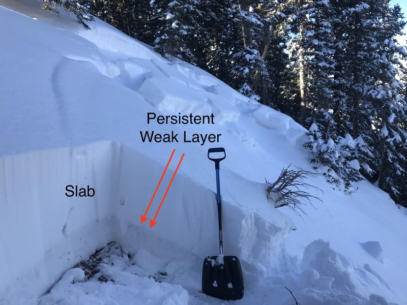
The bottom photo: has a large stripe of grey-ish looking snow, sitting just above the ground. This is what we call a persistent weak layer. It's a layer of old, sugary, faceted snow. The problem with faceted snow is that it's very angular, and it doesn't like to bond to the surrounding snow grains. Once this faceted snow becomes loaded with a slab (stronger snow) it produces very large and destructive avalanches. Slab avalanches are the main killer of backcountry riders and this type of avalanche problem is serious. Continue to avoid all avalanche terrain (slopes steeper than 30° degrees) in the mid elevation northwest through east & upper elevation west through southeast facing terrain. Tracks on the slope are not an indicator of stability.
The top photo: Shows south facing terrain had all the old snow burned off before the Thanksgiving storm leaving us with snow on dirt. As you can see there is no persistent weak layer just above the ground and offers much safer riding conditions. Wondering what that thin line in the middle of the snowpack is? well, it's a suncrust that was formed on the 25th of Novemeber. I was able to propagate a crack just above the crust in my snowpit tests yesterday. Although, this result made me scratch my head - we need more information. It's something to keep in mind if you're planning on hitting steep committing southerly facing terrain.
Top photo: South facing slope, 10,000' in elevation. (no faceted snow).
Bottom Photo: North facing slope, 10,000' in elevation. (Weak and Faceted).
Avalanche Problem #2
New Snow
Type
Location
Likelihood
Size
Description
With over 2 feet of new snow and strong winds in the past 36 hrs you can't rule out - new snow sluffs and new snow soft slabs. This problem tends to stabilize rapidly and is easy to manage. However, this morning we need to continue using safe travel protocol. Waves or pillows of snow, denser thick snow, or cracking are all signs of new snow instability.
General Announcements
This information does not apply to developed ski areas or highways where avalanche control is normally done. This advisory is from the U.S.D.A. Forest Service, which is solely responsible for its content. This advisory describes general avalanche conditions and local variations always occur.