UDOT PLANNED AVALANCHE CLOSURES!!

Forecast for the Salt Lake Area Mountains

Evelyn Lees
Issued by Evelyn Lees for
Saturday, December 1, 2018
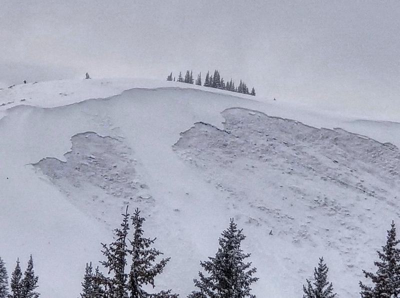
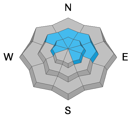
The avalanche danger is HIGH, and backcountry travel in avalanche terrain is not recommended. It’s not the day to be cutting it close - stay off of and out from under mid and upper elevation slopes facing west through north through southeast, where you can easily trigger avalanches 1 to 3 feet deep breaking on sugary facets near the ground. Avalanches can be triggered from a distance, from below and on slopes that have already slid this year.
There is also a CONSIDERABLE avalanche danger on steep slopes with wind drifts, which will be found at the mid and upper elevations.
For those with excellent route finding skills and conservative decision-making, head to low angle slopes with nothing steep above you, which have great riding conditions.
Low
Moderate
Considerable
High
Extreme
Learn how to read the forecast here
Special Announcements
We have a couple of fun events coming up on December 5th and 6th in Salt Lake and Park City. Topics include Recreating in New Zones, Women's Specific Avalanche Awareness, and a slide show from Ascent Magazine. More info about these events HERE.
The UAC IOS App is not compatible with the new UAC website. We are working to release an updated version of the app as soon as possible. Please bear with us as we get the new app completed and released.
Weather and Snow
The cold front cruised through town overnight, dropping another 5 to 10” of low-density snow. Storm totals since Thursday are 1 1/2 to 2 1/2 feet in the Salt Lake, Park City and Ogden area mountains, and about 18” at the mid elevations of the Provo area mountains. Spoiler alert: the front also brought strong west and northwesterly winds – averaging 15 to 25 mph at the mid elevations, and 40 to 45 mph at the upper elevations. These winds should diminish by this afternoon. Temperatures are in the single digits and low teens this morning, and will warm into the teens and twenties today. Another round of low-density snow is forecast for tonight through Sunday.
Our first Week in Review where we summarize significant weather and avalanche activity from the previous week has been published.
Recent Avalanches
There was no slow down in the avalanche activity yesterday – avalanches were triggered in South Monitor, Silver Fork headwall, Highline in Mineral and in upper Cardiff Fork, some remotely and all failing on facets near the ground. Resorts triggered both new and old snow slides with ski cuts and explosives, some of them repeaters – the same slope avalanching a second time in less than 2 weeks. Cracking and collapsing continued to be widespread. Early this morning, a couple of natural avalanches ran in the steep south facing paths of Little Cottonwood.
The avalanche list is HERE, with great info and excellent photos.
Photo: South Monitor slides, Park City ridge line
Video: Highline, Mineral Fork, by Trent Meisenheimer. Get caught in an avalanche like this, and there is no escape.
Ad
Avalanche Problem #1
Persistent Weak Layer
Type
Location
Likelihood
Size
Description
The old faceted snow near the ground is really a bad deal. With a new load of snow and stiffer wind drifts, all the steep slopes with old, faceted snow are dangerous – human triggered avalanches are likely, and can be triggered from a distance, including from below. With stiffer wind slabs added into the mix, avalanches may pull on to ridges or lower angle adjacent slopes. Slopes are starting to repeat – avalanching a second time. Avoidance is the only option.
Simply do not travel on or adjacent to slopes steeper than 30 degrees facing west though north through southeast at the upper elevations, and northwest through easterly at the mid elevations. Existing tracks are not an indication of stability, but rather of a rider who just got away with it.
Below is a great video by Bo Torrey and Andrew Nassetta of our current, northerly facing snow pack. You can see the large load of snow now overloading the weak snow near the ground.
Avalanche Problem #2
Wind Drifted Snow
Type
Location
Likelihood
Size
Description
The strong overnight winds really changed the landscape, transporting the snow into sensitive drifts at the upper and mid elevations. Though the winds were mainly from the west to northwest, watch for loading on all aspects, both along ridge lines and mid slope, along gully walls and steep slope break overs. Waves or pillows of snow, finding denser thick snow or cracking are all signs of wind drifts.
With over 2 feet of new snow, sluffs and new snow soft slabs can be triggered on steep slopes of all aspects. On the steeper southerly facing slopes, they may break down to the sun buried crust.
General Announcements
This information does not apply to developed ski areas or highways where avalanche control is normally done. This advisory is from the U.S.D.A. Forest Service, which is solely responsible for its content. This advisory describes general avalanche conditions and local variations always occur.