Forecast for the Skyline Area Mountains

Brett Kobernik
Issued by Brett Kobernik for
Saturday, March 17, 2018

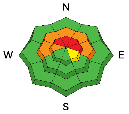
The avalanche danger is HIGH in the upper elevation steep slopes that face northwest, north and east. Human triggered avalanches are almost certain on these slopes today. Travel in avalanche terrain is not recommended which means staying off of and out from underneath steep slopes.
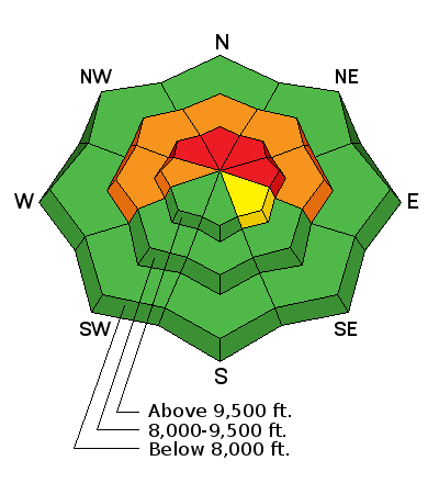
Low
Moderate
Considerable
High
Extreme
Learn how to read the forecast here
Avalanche Warning

THE FOREST SERVICE UTAH AVALANCHE CENTER IN SALT LAKE CITY HAS ISSUED A BACKCOUNTRY AVALANCHE WARNING.

* TIMING…IN EFFECT THROUGH 6PM MST SUNDAY, MARCH 18.

* AFFECTED AREA…FOR THE MOUNTAINS OF THE MANTI SKYLINE AND THE CENTRAL MOUNTAINS OF UTAH INCLUDING THE FISH LAKE MOUNTAINS.

* AVALANCHE DANGER…THE AVALANCHE DANGER FOR THE WARNING AREA WILL BE HIGH SATURDAY AND SUNDAY.

* IMPACTS…TRAVEL IN AVALANCHE TERRAIN IS NOT RECOMMENDED. WEAK SNOW NEAR THE GROUND HAS BEEN OVERLOADED WITH NEW WIND BLOWN SNOW FROM THE LAST FEW DAYS. LARGE AVALANCHES BREAKING TO THE GROUND ARE LIKELY. HUMAN TRIGGERED AVALANCHES ARE VERY LIKELY TODAY AND SUNDAY. STAY OFF OF AND OUT FROM UNDERNEATH STEEP SLOPES. AVALANCHES CAN BE TRIGGERED FROM A DISTANCE EVEN FROM BELOW A STEEP SLOPE.

Special Announcements

We couldn't get out on the snow without the great support from Polaris, Ski Doo, and Arctic Cat as well as KTM and Timbersled. Our local dealers make it happen. Tri-City Performance, Weller Recreation, Northstar's Ultimate Outdoors, Big Pine and Morgan Valley Polaris. We use these machines to monitor the snowpack across the state of Utah. We also use these machines to teach life-saving classes.

Weather and Snow

Moderate speed southeast wind stirred up the newer snow forming drifts in many locations. It is starting to change to a more southwest direction now. Overnight temperatures were in the low to mid 20s. An interesting note on the snowpack is that below about 9000 feet, it is wet, saturated and punchy underneath the new snow. It is almost unsupportable on a machine, skis and definitely on foot. I found my track sinking deep into the wet snow in many areas below 9000 feet. When I stepped off the machine my boots would penetrate to the ground.

Recent Avalanches

No significant activity was reported from Friday. There was some minor wet snow avalanche activity on the sunny slopes. I received reports from snowmobilers up Ephraim Canyon that they were triggering some fresh wind slabs involving only the new snow.

I triggered a large avalanche while doing fieldwork on Thursday. I triggered it from a safe location on top of a ridge. It broke to the ground and was about 800 feet wide and over 5 feet deep at the deepest spot. DETAILS HERE.

Ad
Avalanche Problem #1
Persistent Weak Layer
Type
Location
Likelihood
Size
Description

The weak snow near the ground is likely to produce more avalanche activity especially with another round of new snow added on top of it tonight into Sunday. You just can't get onto the steep upper elevation slopes that face northwest, north and east and expect them not to avalanche. This problem is going to linger into next week after this storm passes. I expect to hear about avalanches breaking to the ground for the remainder of this winter.

Additional Information

We'll see mostly cloudy skies today with high temperatures in the upper 20s and moderate speed southwest wind. Ridgetops will probably be a bit gusty. Snow showers are possible during the day without a whole lot of accumulation expected. Most of the snow will fall tonight into Sunday with 4 to 8 inches possible. Wind will shift around to the northwest tonight. Snow should linger into mid day on Sunday. Weather clears out for early in the week then another storm is shaping up for late in the week.

General Announcements

Support the Utah Avalanche Center through your everyday shopping. DETAILS HERE

We will publish full detailed advisories Saturday and Sunday mornings by 7am. We will also be publishing basic avalanche danger ratings & info during the week.

If you are getting out into the mountains, we love to hear from you! You can SUBMIT OBSERVATIONS ONLINE or EMAIL US

If you would like to have avalanche advisories emailed to you, SIGN UP HERE

We can provide basic avalanche awareness presentations for your school, group or club. To enquire, CLICK HERE