Forecast for the Skyline Area Mountains
Friday, February 28, 2014
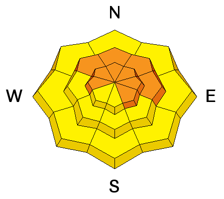
A CONSIDERABLE avalanche danger exists and human triggered avalanches are probable on steep wind drifted slopes, especially those facing the north half of the compass.
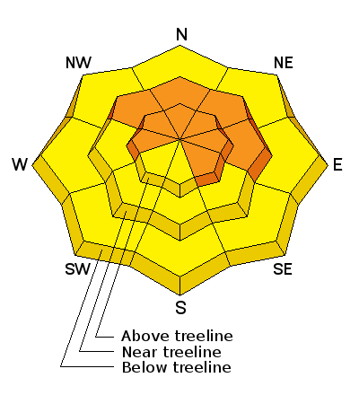
An AVALANCHE WATCH has been issued for the mountains of northern Utah and that includes the Manti-Skyline. Both natural and human triggered avalanches are likely on upper elevation, wind drifted slopes. Dangerous avalanche conditions will materialize this weekend as a powerful storm is expected to slam into the region tonight with strong winds and heavy snow.
The Skyline picked up 6" of new snow yesterday and west-southwest winds bumped up in the afternoon, gusting to 40 mph along the high ridges. Temperatures are in the mid to upper 20's.
No new avalanches have been reported since 
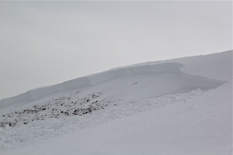
last week's close call when a snowmobiler triggered a very large slide near the Skyline Summit. (photo- Cade Beck) The rider tirggered the slide at the apex of his high mark and was able to ride it most of the way before getting thrown but not buried or injured.
We continue to get views into different areas which unveil the very impressive avalanche cycle that occurred during the big storm two weeks ago. There were many large slides that snapped trees as well as numerous in odd locations such as thicker trees and lower elevations.
Here is the avalanche list that hardly covers a sliver of the terrain that avalanched over the last few weeks:
02/15/2014 | Skyline | Spring Creek | Snowmobiler | 5' | 1/4 mile | Northeast | 9900 | Depth Hoar | Details |
02/13/2014 | Skyline | North Creek | Natural | 2' | 50 | Northwest | 8000 | Facets | Details |
02/12/2014 | Skyline | Lost Creek Reservoir | Snowmobiler | North | 9600 | Details | |||
02/11/2014 | Skyline | Boulger Canyon | Snowmobiler | 2' | 100 | North | Details | ||
02/10/2014 | Skyline | Skyline Mine Road | Natural | 3' | 1/2 mile | North | 8700 | New Snow/Old Snow Interface | Details |
02/10/2014 | Skyline | Big Drift/Skyline Summit | Unknown | unknown | Northeast | 10000 | Details | ||
02/10/2014 | Skyline | GE Hill/Skyline Summit | Details | ||||||
02/10/2014 | Skyline | Skyline Regionwide Avalanche Cycle | Natural | 4' | 500 | Northeast | 9800 | Ground Interface | Details |
02/9/2014 | Skyline | Seeley Creek | Natural | Northeast | 10500 | Facets | Details | ||
02/9/2014 | Skyline | South Fork Birch Creek | Natural | Northwest | 10100 | Facets | Details | ||
02/9/2014 | Skyline | Chokecherry Ridge | Natural | North | 9700 | Facets | Details | ||
02/9/2014 | Skyline | Huntington Reservior | Snowmobiler | 4' | 300 | Northeast | 9600 | Facets | Details |
02/9/2014 | Skyline | Huntington Canyon | Natural | Facets | Details | ||||
02/9/2014 | Skyline | South Fork North Creek | Natural | North | 10000 | Facets | Details | ||
02/9/2014 | Skyline | North Fork | Natural | North | 10000 | Facets | Details | ||
02/9/2014 | Skyline | Blue Slide Fork | Natural | North | 10000 | Facets | Details | ||
02/9/2014 | Skyline | Pleasant Creek | Natural | Facets | Details | ||||
02/8/2014 | Skyline | Electric Lake | Natural | 3' | 250 | North | 9400 | Facets | Details |
Strong winds and heavy snow will stress weak layers buried deep in the snowpack. As the weekend storm materializes avalanches have the possibility to break to the ground. Steep, upper elevation, wind drifted slopes facing the north half of the compass should be avoided.
There are more thoughts, photos and videos on the deep slab issue HERE.
Darce Trotter also submitted some thoughts HERE
Fresh drifts will be sensitive to the additional weight of a rider today. These should be mostly manageable in depth and width and breaking at or below our skis, board, or sled. However, in steep, rocky terrain a fresh drift has the possibility to break into weaker layers of snow, buried deeper in the snowpack, creating a slide that gets quickly out of hand. As always, look for and avoid any fat, rounded pillow of snow, especially if it sounds hollow like a drum.
A moist Pacific storm system moves through the region beginning today, with precipitation likely beginning this evening. West and southwest winds increase significantly for the latter half of today, and remain strong into Saturday morning. The region should fair pretty well with periods of snow through Saturday night.
Donate to your favorite non-profit –The Utah Avalanche Center. The UAC depends on contributions from users like you to support our work.
Benefit the Utah Avalanche Center when you buy or sell on ebay - set the Utah Avalanche Center as a favorite non-profit in your ebay account here and click on ebay gives when you buy or sell. You can choose to have your seller fees donated to the UAC, which doesn't cost you a penny.
Utah Avalanche Center mobile app - Get your advisory on your iPhone along with great navigation and rescue tools.
The information in this advisory is from the US Forest Service which is solely responsible for its content. This advisory describes general avalanche conditions and local variations always occur.
This advisory will be updated by 7:00 AM Saturday, March 1st, 2014 or sooner if conditions warrant.