Join us at our 2nd Annual Blizzard Ball

Forecast for the La Sal Mountains Area Mountains

Eric Trenbeath
Issued by Eric Trenbeath on
Monday morning, December 23, 2013

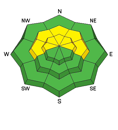
There is currently a LEVEL 2 (MODERATE) avalanche danger at this time. Buried, persistent slabs overlying weak, sugary snow, remain the prime area of concern. Though continually lessening, this problem still exists on mid to upper elevation slopes steeper than about 35 degrees that have a NW-NE aspect. Elsewhere in the range, the avalanche danger is generally LOW.

Low
Moderate
Considerable
High
Extreme
Learn how to read the forecast here
Special Announcements

This advisory is generated from fieldwork performed on Sunday, December 22, and weather observations taken on the morning of December 23. It is to be used as a guideline for back-country travelers for the upcoming week. A large ridge of high pressure is building off the West Coast and this will keep us under a dry, northwest flow, with little change in the weather over the next 5 days. This advisory will be updated should significant changes occur.

Weather and Snow

I covered quite a bit of ground in the mid-upper elevations yesterday, and was surprised to see how much conditions had freshened up. The mountains picked up 4" -8" of light density snow between Thursday and Saturday, and the overall effect on the snow surface was remarkable. I found good "dust on crust" conditions on southerly aspects, and where the new snow had fallen on older, re-crystallized powder, skiing and riding conditions were excellent. Above tree line, there are some wind scoured areas on the most exposed terrain, but many of the wind crusts formed by the strong NW winds of a week ago were covered with several inches of fresh snow. Southerly aspects should be ok for another day until the sun has its way them, but as long as winds stay relatively well behaved, good skiing and riding conditions should last on shady aspects through the week. There is currently 24" on the ground at the Geyser Pass Trailhead, and 39" in Gold Basin.

More detailed observations including photos and a pit profile are available here

Avalanche Problem #1
New Snow
Type
Location
Likelihood
Size
Description

Buried, persistent slabs continue to be the main area of concern though the odds of triggering one of these slabs are growing less likely. However, very weak, faceted, sugary snow snow still underlies them and a slide triggered under these conditions would be large and dangerous. Continue to avoid steep, northerly facing, mid-upper elevation terrain. Be particularly leery of rocky terrain and areas beneath cliff bands. Suspect areas with a smooth, rounded appearance, and be alert to the many steep convexities in our mountain range. This type of terrain can lure you far down a slope to where if a slide is released, it will fracture well above you.

Additional Information

Things are going to be pretty quite in the mountains this week as a ridge of high pressure builds off the West Coast and strengthens over our area keeping us under a dry NW flow. We will see a slight increase in winds tonight and into Tuesday from the WNW. Sunny skies and high temperatures of around 30 degrees will continue through the week, with lows dipping into the mid teens.

Today: Mostly sunny, with a high near 27. North northwest wind 10 to 15 mph.
Tonight: Partly cloudy, with a low around 18. West wind around 10 mph.
Tuesday: Mostly sunny, with a high near 30. West northwest wind 10 to 15 mph, with gusts as high as 25 mph.
Tuesday Night: Mostly clear, with a low around 14. Calm wind.
Christmas Day: Sunny, with a high near 30. Calm wind becoming north northwest around 5 mph in the afternoon.
Wednesday Night: Mostly clear, with a low around 18.
Thursday: Sunny, with a high near 32.
Thursday Night: Mostly clear, with a low around 20.
Friday: Sunny, with a high near 33.

Current wind and temperature readings from Pre-Laurel Peak

Temperature and new snow totals in Gold Basin

General Announcements

If you are out and about in the mountains, I'd love to know what you are seeing. Please submit your OBSERVATIONS HERE

LUNA GROOMING INFORMATION: The grooming schedule is now in full swing with regular grooming scheduled for Mondays and Fridays.

ROAD CONDITIONS: Though not recently plowed, the new snow over the weekend has been sufficiently packed down by traffic.

UAC MOBILE APP: Get your advisory on your iphone with this app