Forecast for the Uintas Area Mountains

Craig Gordon
Issued by Craig Gordon for
Wednesday, April 3, 2019
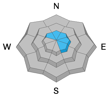
In the wind zone, at and above treeline, the avalanche danger is MODERATE and human triggered avalanches are POSSIBLE, especially on steep wind drifted slopes facing the north half of the compass.
Lose the wind and you lose the problem.... mid and lower elevation terrain generally offers LOW avalanche danger with both human triggered and natural avalanches UNLIKELY.
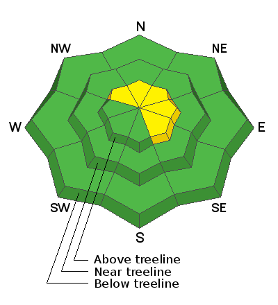
Low
Moderate
Considerable
High
Extreme
Learn how to read the forecast here
Special Announcements
When the forecasting ends, the UAC’s work keeps going strong. Summer is a busy time for the UAC. During the summer we are working hard on our fall and winter planning; putting together the Fall Fundraiser and USAW; updating our awareness and education programs; this summer we will be finishing up the website redesign project. Your donation shows you’re invested in this community all year round! You can still be part of the UAC’s success in 2019. Consider making a donation HERE by April 8.
Weather and Snow
A nice shot o' snow developed over the region yesterday afternoon, continuing through the night, delivering 4"-6" of medium density snow across the range. Currently, under mostly cloudy skies, temperatures are balmy... in the upper 20's and low 30's. Bigger news are the southwest winds which have been blowing 25-40 mph since about 5:00 last night. Riding and turning conditions vastly improved overnight with our fresh coat of white paint and you'll want to steer your snow vehicle of choice to mid elevation, wind sheltered terrain where you'll find soft, surfy, spongy, snow.... along with a little taste of Beowulf iteration :)
Above is hourly data from Trial Lake (9,945')
And Lofty Lake Peak (11,186')
Doing some weather station maintenance yesterday... you know it's a big year when the snow depth site in Upper Moffit Basin is nearly buried.
To view more regional weather stations click here.
Recent Avalanches
No significant avalanche activity to report from yesterday.
Recent trip reports and avy activity found HERE.
Ad
Avalanche Problem #1
Wind Drifted Snow
Type
Location
Likelihood
Size
Description
Strong ridgetop winds will have no problem whipping yesterday's storm snow into fresh drifts sensitive to our additional weight. Looking at wind speeds.... we're at the right velocity where snow gets stripped from windward slopes (south and southwest facing terrain) creating fresh drifts on the leeward side (northwest, north, northeast, east, and southeast facing terrain). And while 6" might not seem like a lot of snow, it never surprises me how Uinta winds channel through terrain features, creating drifts a little deeper, which break a little wider than you might expect. The good news... this is an easy avalanche problem to avoid and you can have blast by simply steering clear of steep, wind drifted, upper elevation terrain.
Additional Information
Today, expect mostly cloudy skies with light snow showers through mid afternoon with an additional couple inches stacking up. Winds shift to the west and northwest later this morning and blow in the 20's and 30's along the high ridges and high temperatures climb into the mid 30's. Skies clear overnight as brief high pressure builds for Thursday only to be replaced by a weak system slated for Friday and a stronger storm on tap Saturday.
General Announcements
The information in this advisory expires 24 hours after the date and time posted, but will be updated by 7:00 AM Thursday April 4th, 2019.
If you're getting out and about, please let me know what you're seeing especially if you see or trigger and avalanche. I can be reached at [email protected] or 801-231-2170
It's also a good time to set up one of our very popular avalanche awareness classes. Reach out to me and I'll make it happen.
This information does not apply to developed ski areas or highways where avalanche control is normally done. This advisory is from the U.S.D.A. Forest Service, which is solely responsible for its content. This advisory describes general avalanche conditions and local variations always occur.