Forecast for the Uintas Area Mountains

Craig Gordon
Issued by Craig Gordon for
Saturday, March 5, 2022
HEADS UP -
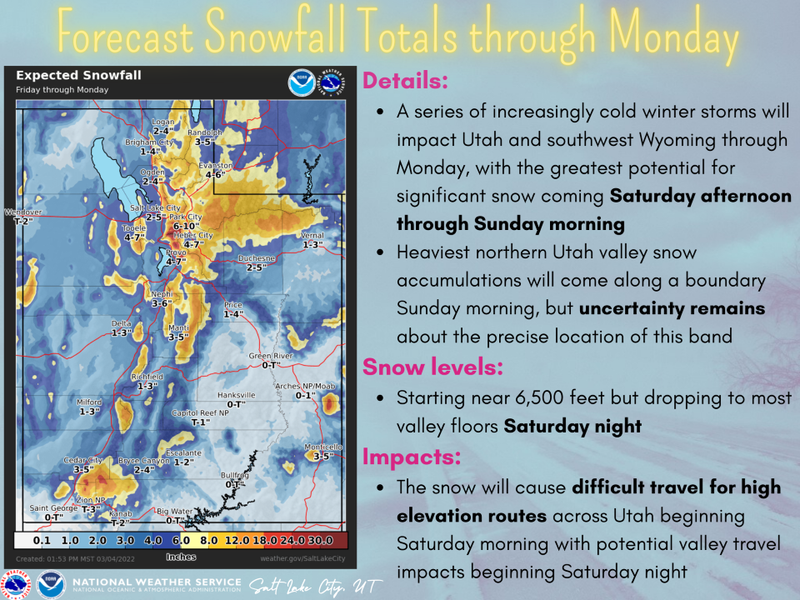
A series of storms is just beginning to evolve and that leads to a rising avalanche danger this weekend.
Today's avalanche danger is MODERATE and most pronounced near and above treeline, where additional snow stacks up on top of a pre-existing, weak layer of sugary snow. Human triggered slides breaking deeper and wider than you might expect are POSSIBLE, especially on steep, mid and upper elevation slopes facing the north half of the compass. Be alert to changing weather conditions today which will create touchy avalanche conditions, particularly if we pile up more snow or winds are stronger than forecast.
Looking for LOW avalanche danger? Well then, simply swing over to the south half of the compass or tag some lower elevation trailhead shots where human triggered avalanches are UNLIKELY.

Low
Moderate
Considerable
High
Extreme
Learn how to read the forecast here
Weather and Snow
NOWCAST-
Light snow began falling late Friday afternoon and continues as I compile this forecast at o'dark thirty this morning. It's a welcome shot of moisture, about .30" of H2O, stacking up an evenly distributed 3" of medium density snow in the high country across the range. Temperatures moderated somewhat overnight and currently register in the teens and low 20's. A band of thick clouds drape our mountains this morning and southwest winds hardly spin mountaintop anemometers, blowing just 10-15 mph along the high ridges. A fresh coat of white paint delivers a two-fer and goes a long way to improve riding conditions along with a shot of increased endorphins to help stoke powder starved spirits :)
FORECAST-
Look for mostly cloudy skies with light snowfall throughout a good portion of the morning and early afternoon, delivering an additional 1"-3" of snow. Temperatures climb into the low 30's and southwest winds should be rather well-behaved, averaging 20 mph with a few gusts in the 30's and 40's near the high peaks. Cold, moist air arrives tonight and that should deliver 4"-8" of snow with higher amounts if the stars, moon, and ouija board align.
FUTURECAST-
The graphic above lays out the timeline for a stormy period through Monday.
Trip reports and current state of the snowpack observations are found HERE.

Looking for real-time temps, snow, or wind?
Click HERE and then on the "western Uinta" tab for western Uinta specific, weather station network.
Recent Avalanches
A falling piece of cornice on Tuesday in upper Moffit Basin triggered an avalanche (2' deep by 200' wide) that is a heads up of things to come. I explain the set up in this video.

Your input is vital and we're interested in what you're seeing. Please contribute to this great community resource and go here to fill out an observation.
Ad
Avalanche Problem #1
Persistent Weak Layer
Type
Location
Likelihood
Size
Description
The image above illustrates our setup... notice the smooth texture of the new snow on top of rough, granular looking weak snow underneath.
Now... here's what's going on. The midwinter drought of January and February created a persistent weak layer (PWL) of sugary facets on the snow surface which was buried by last week's light snow. Despite record breaking heat last week, the sugary layer remains cold, dry, and weak. The combo is found on mid and upper elevation slopes facing the north half of the compass along with a sliver of southeast facing terrain. This is our new problem child, especially where a cohesive slab rests on top. Mark commented... "To be honest, it's hard to believe how dry and weak this layer is until you see it and feel it with your own hands."
Here's where it gets tricky... large swaths of upper elevation terrain facing the north half of the compass were blasted by the winds prior to our recent storms and weak snow distribution is spotty at best. That means you'll need to evaluate each slope on an individual basis.
Additional Information
Your observations are important, so please let me know what you're seeing... click HERE and contribute to this amazing community based program
General Announcements
The information in this forecast expires 24 hours after the day and time posted, but will be updated by 07:00 Sunday, March 6th.
Before it gets too crazy, now is the time to book an avalanche awareness presentation for your group, club, or posse. You can reach me directly at 801-231-2170 or [email protected]
This forecast is from the U.S.D.A. Forest Service, which is solely responsible for its content. This forecast describes general avalanche conditions and local variations always occur.