Forecast for the Uintas Area Mountains

Craig Gordon
Issued by Craig Gordon on
Friday morning, March 27, 2026

Corn isn't just a vegetable it's a snow harvesting religion and last night's robust refreeze anxiously awaits your cultivating arrival.

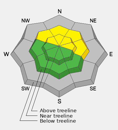
A rock solid, overnight refreeze delivers mostly LOW avalanche danger and human triggered avalanches are unlikely for a good portion of the day. If temperatures rise more rapidly than expected the avalanche danger will shift accordingly, bumping into the MODERATE category. Steep, rocky, mid and upper elevation polar slopes, especially those with a shallow snowpack are most suspect where human triggered avalanches are POSSIBLE during the heat of the day.

Grey color on the danger rose indicates little to no snow at lower elevations... apologies to the snowpack. Sorry that you feel that way, the only thing there is to say... every silver lining's got a touch of grey :)

Low
Moderate
Considerable
High
Extreme
Learn how to read the forecast here
Special Announcements

A new version the UAC's mobile app has been released with many new features and performance improvements. Download our app today, available on iPhone and Android. Learn more HERE.

Weather and Snow

Nowcast - High, thin clouds drift through the region early this morning, the tail end of a dry cold front that delivered a breath of fresh air along with overnight temperatures cratering in the teens and low 20's F°. It's crisp near the high peaks as winds blow in the 30's and 40's from the northwest.

Forecast - A stunning day is on tap with mostly sunny skies and temperatures climbing into the high 40's F°. Winds shift to the west and southwest and decrease somewhat as the day wares on. Overnight lows dip into the low 30's F°.

Futurecast - High pressure builds for the weekend, ushering in a return to unseasonably sultry weather through about Sunday. The warm before the storm kicks in Monday before we shift gears to a cooler, wetter pattern beginning midday Tuesday. Looks like a warm, wet, April Fools Day impulse with a colder system slated to round out the workweek.

Travel Conditions -

Looking east towards the High Uintas and Central Mountains, there's plenty of snow on polar slopes above 10,000'. Below that... travel, access, and type two fun conditions present some serious challenges and oh yeah... lack of coverage.

Recent Avalanches

No new avalanche activity reported in the past 24 hours.

Recent slides and trip reports from across the range are just a click away... below!

Avalanche Problem #1
Wet Snow
Type
Location
Likelihood
Size
Description

Today's temperatures are more in line with what we should expect for March and I think that'll pump the brakes on damp snow and wet avalanche issues. However, steep, rocky slopes (like in the image above) and terrain that's avalanched multiple times this year remains suspect.

Here's a few things that'll dictate the way I move in the mountains today-

  • Avoiding big terrain during the heat of the day, and keeping off of and out from under, large avalanche paths and runouts.
  • Watching for the pack to become punchy and unsupportable under my ride, rig, board, or boards.
  • And finally, if pinwheels, rollerballs, or loose rock starts cascading down from above, it's a sure sign the mountain is feeling the heat and it's time to switch gears on our objectives and snow-centric activities.
General Announcements

We are always looking for snow and avalanche observations or just general riding conditions. Reach out to us with questions, concerns, or if you see anything in your travels! Contact us directly through the info below:

Craig Gordon -- [email protected] -- 801 231 2170

This forecast is from the U.S.D.A. Forest Service, which is solely responsible for its content. This forecast describes general avalanche conditions, and local variations always occur. This forecast was issued on Friday, March 27, at 03:30 and expires 24 hours after it was issued. We'll update this information by about 7:00 AM tomorrow.