Forecast for the Uintas Area Mountains

Craig Gordon
Issued by Craig Gordon for
Saturday, March 23, 2019
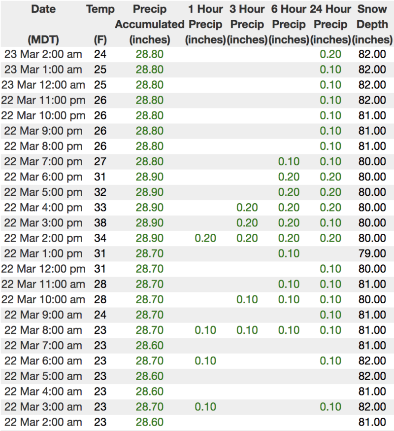
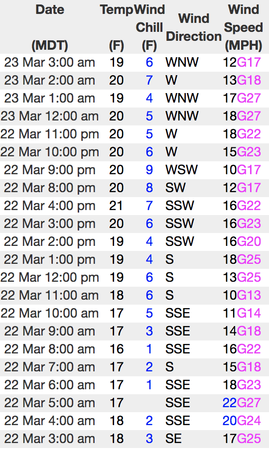
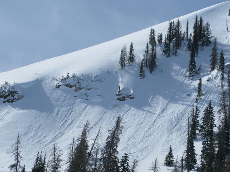
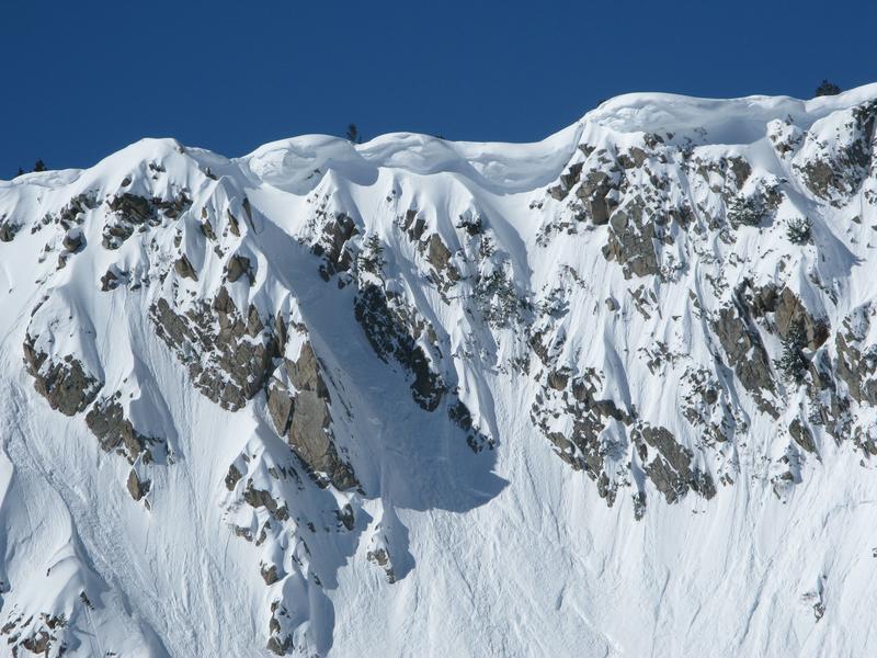
The avalanche danger is generally LOW. Both human triggered and natural avalanches are unlikely. Remember though, LOW danger doesn't mean NO danger... it's a mountain environment after-all. So, if you're getting into steep, technical terrain facing the north half of the compass remember, there may be a rogue drift or two large enough to boss you around.
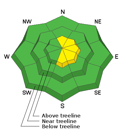
Low
Moderate
Considerable
High
Extreme
Learn how to read the forecast here
Weather and Snow
Under mostly cloudy skies, a few light snow showers linger in the wake of last nights storm which had a hard time getting going, only delivering an inch or two of new snow. Currently, temperatures are in the mid 20's and west-northwest winds blow in the 20's along the high ridges. Riding and turning conditions have taken a bit of a hit this week and it's a little rugged out there this morning. However, any day in the mountains is better than cleaning out the garage, and with a little extra effort, you'll still find shallow soft snow in upper elevation, wind sheltered, shady terrain.
Above is hourly data from Trial Lake (9,945') and Windy Peak (10,662'). To view more regional weather stations click here.
Recent Avalanches
No significant avalanche activity observed or reported.
Recent trip reports and avy activity found HERE.
Ad
Avalanche Problem #1
Wind Drifted Snow
Type
Location
Likelihood
Size
Description
A couple things to keep in mind during your travels today-
A few fresh drifts materialized overnight and these will be reactive to our additional weight. Limited to steep, leeward slopes in the wind zone, today you'll want to look for and avoid any fat, rounded piece of snow, especially if it sounds hollow like a drum. Out of the wind, upper elevation wind sheltered terrain harbors weak surface snow and while mostly manageable in size, a large loose snow sluff in steep, technical, north facing terrain could knock you off your skis, board, or sled and take you for an unexpected ride.
And finally don't forget-
Cornices are ginormous and may break back further than you might expect. You definitely wanna give these large, unpredictable pieces of snow a wide berth and not ruin someones day below by inadvertently knocking a boxcar size piece of snow down on them.
Additional Information
Not much going on in the weather department. Today we can expect mostly cloudy skies, temperatures rising into the 30's, and westerly wind blowing in the 20's along the high peaks. A better shot of snow materializes tonight through early Sunday morning, followed by a break early in the week and a more robust series of storms to round out the work week.
General Announcements
The information in this advisory expires 24 hours after the date and time posted, but will be updated by 7:00 AM Sunday March 24th, 2019.
If you're getting out and about, please let me know what you're seeing especially if you see or trigger and avalanche. I can be reached at [email protected] or 801-231-2170
It's also a good time to set up one of our very popular avalanche awareness classes. Reach out to me and I'll make it happen.
This information does not apply to developed ski areas or highways where avalanche control is normally done. This advisory is from the U.S.D.A. Forest Service, which is solely responsible for its content. This advisory describes general avalanche conditions and local variations always occur.