Donate to Our Spring Campaign or Bid on our Spring Auction to Support Forecasting

Forecast for the Uintas Area Mountains

Craig Gordon
Issued by Craig Gordon on
Wednesday morning, March 19, 2025
Heads up... it's spring and snow conditions, snow quality, and avy danger can change rapidly.
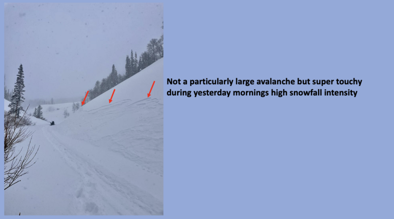
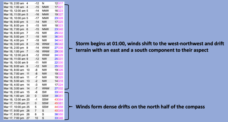
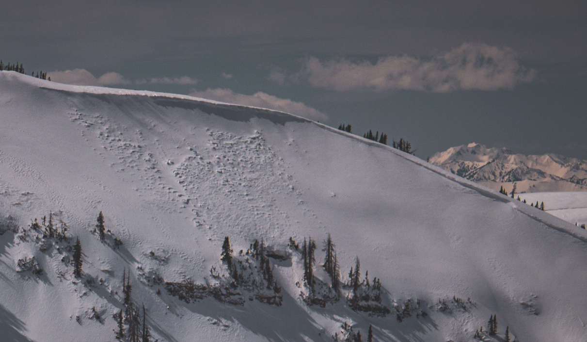
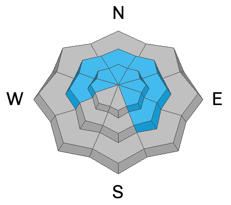
In the windzone at and above treeliine, you'll find CONSIDERABLE avalanche danger around the compass. Fresh wind drifts and storm snow will respond to our additional weight and human triggered avalanches are LIKELY. And remember... faceted snow still exists in terrain harboring a shallow snowpack. Pulling on the avalanche dragons tail in steep, rocky terrain or slopes that have avalanched early in the season will result in a body-bruising slide, that fails on old snow and breaks deeper and wider than we might expect.
Fresh snow offers a short-term problem and will react to our additional weight. Human triggered avalanches are POSSIBLE on sustained steep slopes, in mid and low elevation terrain where you'll find MODERATE avalanche danger.
Low
Moderate
Considerable
High
Extreme
Learn how to read the forecast here
Special Announcements
Our Spring Campaign is in full swing, and there are two great ways to support forecasting, awareness, and education across Utah: Donate to our Spring Campaign or bid on items in our Spring Auction
Every dollar helps keep the backcountry community on top. Thank you for your support!
Weather and Snow
Nowcast- Overnight, northwest winds mellowed into the teens, temperatures cratered into the single digits, and skies cleared in the wake of yesterday's storm. And wow... what a storm it was! From north to south it looks like an evenly distributed fresh coat of white paint with 12" of snow and .90" H2O stacking up in the past 24 hours. Northwest flow storm favored zones like Upper Whitney and Humpy Basin's did squeak out a couple extra inches of snow and totals are closer to 16" (overachievers :).
Forecast- A stunning day is on tap with mostly sunny skies, northwest winds blowing to 20 mph, and temperatures rising into the upper 20's. Late in the day, southwest winds ramp into the 40's, clouds drift into the region late tonight, and overnight lows dip into the low 20's.
Futurecast- The first of two weak impulses slide through the Uinta zone Thursday through early Friday, with 2"-4" of snow expected. A break in the action for early Saturday and then similar amounts are in the queue with a second wave moving through Saturday night through Sunday. And then it's done. Next week is warm and dry.
Travel & Riding Conditions- It's been a great run, but this is the last of the cold, deep, storms. So... get out and get after it early before strong spring sunshine beats you to the punch... cause it's over-the-hood and over-the-head!
Recent Avalanches
Avy-savvy forecaster extraordinaire, but more importantly... super, solid human, Trevor Katz reported this shallow, yet very connected storm slab releasing on a steep road cut during the height of yesterday's storm. More from TK here.
Ad
Avalanche Problem #1
Wind Drifted Snow
Type
Location
Likelihood
Size
Description
Above is a 31 hour wind run from Windy Peak (10,662') illustrating duration, velocity, and dramatic shift in wind direction.
Winds have been all over the map, drifting slopes around the compass, especially on the leeward side of ridges and terrain features like chutes, gullies, and sub-ridges near the high peaks. While I don't think today's drifts are gonna be hypersensitive, they may be camouflaged by a couple inches of fresh snow, making them harder to detect. In the windzone above treeline, a fresh drift could definitely pack a bigger punch then you might've bargained for. You know the program... lose the wind and you lose the problem. Simply steer yourself away from fat, rounded pillows of snow and towards wind sheltered terrain. You reduce the hazard, yet increase the chances of having an even more epic day... done and done.
A natural windslab that most likely occurred on Sunday, during an intense period of wind -- Thanks Bo, for the great photo.
Avalanche Problem #2
Persistent Weak Layer
Type
Location
Likelihood
Size
Description
New snow and wind have the potential to wake up the PWL avalanche dragon today, especially in terrain that has remained thin all season like slopes that avalanched earlier this winter. Here's the deal and here's where it gets tricky... we're not going to see obvious red flags like cracking, or hear big, booming whoomphing sounds or experience heart-stopping collapses. However, if you do some detective work and trench down a bit you'll find weak, faceted snow buried a couple feet below the snow surface. We might forget about the layering, but recent avalanches breaking to these layers tell us the snowpack has an amazing memory.
Chad was in the Silks Basin area and found a swath of terrain with a very shallow snowpack. Although on the extreme end of the spectrum, it's evidence that our structure is poor on slopes that are thin, or have avalanched repeatedly this season.
Avalanche Problem #3
New Snow
Type
Location
Likelihood
Size
Description
From tip to tail, a lot of new snow stacked up yesterday and sustained steep slopes will produce small, yet sensitive storm snow sluffing and shallow slabs. Generally a manageable avalanche problem unless the sluff we're caught in dumps into a terrain trap like a gully or road cut.
Additional Information
  • We come to you with heavy hearts and great sadness this morning to confirm an avalanche accident on Friday, March 7th near Hoyt Peak, involving 51 year old Micheal Janulaitis from Marion, Utah. Micheal used a snowbike to access the terrain, but was caught, carried, and killed in an avalanche while skiing a steep, northeast facing run on Hoyt Peak.Huge thanks to the Department of Public Safety, Park City Mountain Resort and Canyons Village Snow Safety and Ski Patrol teams, along with Wasatch Backcountry Rescue for the hard work recovering Micheal and returning him to his family. Micheal was a friend of Utah Avy and we feel privileged for the time we got to spend together. This is a tremendous loss for our backcountry family and we will miss him deeply. We are compiling accident details and a preliminary report is available here.
General Announcements
We are always looking for snow and avalanche observations or just general riding conditions. In the meantime reach out to us with questions, concerns, or if you see anything in your travels! Contact us directly through the info below:
This forecast is from the U.S.D.A. Forest Service, which is solely responsible for its content. This forecast describes general avalanche conditions and local variations always occur. This forecast was issued on Wednesday, March 19th at 03:30 AM and expires 24 hours after it was issued.