Donate to Our Spring Campaign or Bid on our Spring Auction to Support Forecasting

Forecast for the Uintas Area Mountains

Andrew Nassetta
Issued by Andrew Nassetta on
Tuesday morning, March 18, 2025
CONSIDERABLE danger exists at mid and upper-elevations and human-triggered avalanches are LIKELY where new snow and strong winds have created deep, sensitive drifts reactive to our additional weight. Additionally, faceted snow lingers in the middle of our snowpack and in shallow areas or on slopes that have previously avalanched it is POSSIBLE for us to trigger a slide 3-5' deep breaking wide across the slope.
As new snow and strong winds continue today, pay attention to obvious red flags, how the storm snow is falling and what the wind is doing. Expect the danger to rise depending on wind and snow totals, and keep your eyes peeled for changing conditions as you step out the door!
Low
Moderate
Considerable
High
Extreme
Learn how to read the forecast here
Special Announcements
Our Spring Campaign is in full swing, and there are two great ways to support forecasting, awareness, and education across Utah: Donate to our Spring Campaign or bid on items in our Spring Auction
Every dollar helps keep the backcountry community on top. Thank you for your support!
Weather and Snow
Nowcast A southwest flow shifts northwest first thing this morning and helps snow stack-up on the stakes with 5” at Trial Lake as of 0500 AM, while the south end brings up the rear closer to 2”. South and southwest winds cranked yesterday and on through the night averaging 45 MPH and gusting into the 60's. Air temps were mild, but are dropping quickly this morning as the storm shifts to the north, and current readings are right around 15℉ at 10,000’.
Forecast Today, the storms rears up mid-morning with highest precip rates coming before lunch. I expect an additional 4-8” to pile up by supper, with snow levels reaching the valley and affecting the day's commutes. Expect steady, cool temperatures in the teens, while northwest winds will blow in the 20’s gusting into the 30’s throughout the day.
Futurecast Weather backs off late tonight into tomorrow with a quick break Wednesday, then it's back to an active pattern that looks hopeful heading into the weekend.
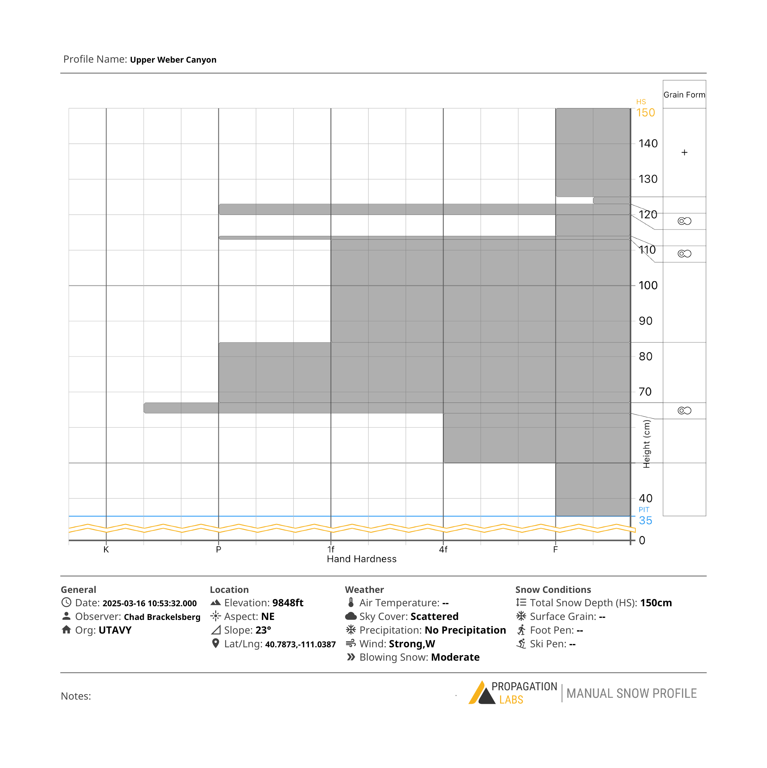
Travel & Riding Conditions A winter storm has impacted the area and conditions should turn to hero by the end of the day. Variable snow surfaces were present on almost all aspects prior to the storm, but the good news is most were supportable and riding well. On the south half of the compass, new snow sits atop a variety of crusts and windboards that should bond ok with the new snow. On the polars, new snow rests on the wind board and decomposing powder from the last storm and I would start my day there while the snow stacks up on the southerly aspects. Today, I 'm heading for friendly slope angles away from the avalanche hazard where I am not feeling the bottom on every turn or trench while enjoying smooth, surfy, new snow.
Recent Avalanches
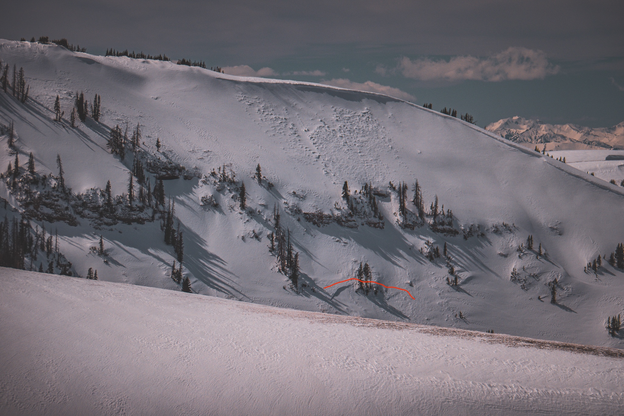
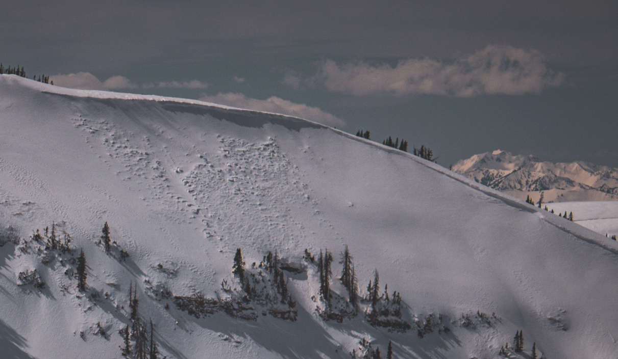
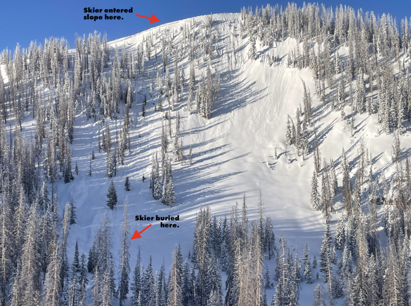
Bo reported a natural avalanche from the Chalk Creek area yesterday where a cornice fall triggered a windslab, subsequently triggering a persistent slab avalanche below as it traveled down the slope. Check out all the info, slides, and snow beta from across the range and beyond, here.
A northeast facing slope, at 10,400' where a small windslab occurred naturally, ran its track, and triggered a persistent slab avalanche breaking into old, faceted snow further down the slope.
Ad
Avalanche Problem #1
Wind Drifted Snow
Type
Location
Likelihood
Size
Description
Sustained, strong, southerly winds blowing in the 30's and 40's combined with new snow have not only created fresh, sensitive wind-drifts, but they have also camouflage old hard slabs and lingering drifts from the past few days. Simply put, today's windslabs will be bigger than yesterdays, more sensitive, and growing in size with more snow and wind, today. Even in wind-resistant terrain, off of ridges and away from the high peaks where we might not typically find drifted snow, pay attention to how the new snow settles and what the winds are doing to it -- Sometimes a touch of wind is all we need for lighter-density new snow to slab-up and sneak-up on us. Keep your eyes peeled and avoid any fat, rounded pillow of snow and growing cornices that will be reactive to our additional weight today.
In times of uncertainty and loading events (like we are currently in), we are not always sure what it will take to wake up the bigger avalanche dragon, but remember even a small windslab can break wider than we expect, or step down into old snow and create a situation we did not buy into and one we might not walk away from.
A natural windslab that most likely occurred on Sunday, during an intense period of wind -- Thanks Bo, for the great photo.
Avalanche Problem #2
Persistent Weak Layer
Type
Location
Likelihood
Size
Description
New snow and wind have the potential to wake up the dragon today. Several persistent weak layers of snow, now buried a couple feet from the snow surface have become stubborn but recent avalanches clue us in that we are not out of the woods yet. In isolated areas where the snowpack is less than 5' deep we still have poor snowpack structure with a hard slab sitting on top of soft, weaker snow. A shallow snowpack combined with steep, rocky terrain in the windzone seems to put the crosshairs on where we are most likely to trigger today's "won't-make-it-home" avalanche.
The tricky part is, unless you dig down and check it out, you may never know it exists. You may not see obvious red flags like cracking, or hear collapsing, however if you do some detective work and trench down a bit you'll find weak, faceted snow buried within a couple feet of the snow surface – as Craig likes to say, that is where our problem child of the snowpack lives.
Chad was in Silks Basin area and found a spot with a very shallow snowpack, and although on the extreme end of the spectrum, goes to show evidence that our structure is poor in shallow areas that are thin, or have avalanched repeatedly this season.
Additional Information
  • We come to you with heavy hearts and great sadness this morning to confirm an avalanche accident on Friday, March 7th near Hoyt Peak, involving 51 year old Micheal Janulaitis from Marion, Utah. Micheal used a snowbike to access the terrain, but was caught, carried, and killed in an avalanche while skiing a steep, northeast facing run on Hoyt Peak.Huge thanks to the Department of Public Safety, Park City Mountain Resort and Canyons Village Snow Safety and Ski Patrol teams, along with Wasatch Backcountry Rescue for the hard work recovering Micheal and returning him to his family. Micheal was a friend of Utah Avy and we feel privileged for the time we got to spend together. This is a tremendous loss for our backcountry family and we will miss him deeply. We are compiling accident details and a preliminary report is available here.
General Announcements
We are always looking for snow and avalanche observations or just general riding conditions. In the meantime reach out to us with questions, concerns, or if you see anything in your travels! Contact us directly through the info below:
This forecast is from the U.S.D.A. Forest Service, which is solely responsible for its content. This forecast describes general avalanche conditions and local variations always occur. This forecast was issued on Tuesday, March 18th at 06:00 AM and expires 24 hours after it was issued.