Donate to Our Spring Campaign or Bid on our Spring Auction to Support Forecasting

Forecast for the Uintas Area Mountains

Andrew Nassetta
Issued by Andrew Nassetta on
Monday morning, March 17, 2025
Today’s avalanche danger is CONSIDERABLE on upper elevation slopes facing west through north through southeast, where human-triggered wind drifts up to 3’ are LIKELY. At mid and upper elevations on the north half of the compass wind-drifted snow has added additional weight to our persistent weak layers, and it is POSSIBLE for us to trigger a slide 3-5' deep breaking wider across a slope than we may expect.
All other terrain offers LOW avalanche danger, and a variety of snow surface conditions created by spring-like weather. I’m gunning for protected, upper elevations slopes where snow is cold and sheltered while still avoiding large slopes that have the potential to produce a large avalanche.
Low
Moderate
Considerable
High
Extreme
Learn how to read the forecast here
Special Announcements
Our Spring Campaign is in full swing, and there are two great ways to support forecasting, awareness, and education across Utah: Donate to our Spring Campaign or bid on items in our Spring Auction
Every dollar helps keep the backcountry community on top. Thank you for your support!
Weather and Snow
Nowcast South and southwest cranked yesterday and on through the night, averaging 30 MPH and gusting into the 50's. Air temps are mild this morning, registering in the 20's, but are knocked down to the single digit's (℉) by windchill at upper elevation peaks and ridgelines. Broken skies start off the morning with increasing clouds after breakfast.
Forecast Today, the incoming cold front will bring increasing clouds, strong winds and decreasing temperatures. It may feel balmy and spring-like at the trailheads, but winter will be at work up high and you can xpect a high of 25℉ as winds hammer from the south between 30-50 MPH and gusts nearing 70 MPH.
Futurecast The storm looks to arrive to the party later this evening, and am hopeful that we should stack up 8-12" of snow while favoring the south half of the range. Things should taper off Tuesday night into Wednesday, while a short break in the action brings us into the weekend that looks hopeful for more snow.
Travel & Riding Conditions It is nearly spring, but the Uinta's are still in the winter form for the most part. Polar aspects are riding good at mid and upper elevations in sheltered terrain where wind and sun have not affected the surface snow much. On the south half of the compass, settled pow on a supportable base is mixed with variable snow surfaces from yesterday's greenhousing, increasing temps, and strong winds. Work the aspects clockwise throughout the day, fine tune your slope angles, and you will be sure to find what your looking for.
A north facing slope near Wolf Creek Pass at 10,500' that has been heavily wind-loaded and remains hanging in the balance. I am still avoiding large pieces of avalanche terrain like this, on slopes with a northerly component.
Recent Avalanches
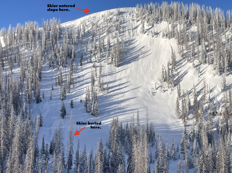
Avalanche activity within the past 24hrs is confined to surface instabilities with wind being the creator and driver of small hard and soft slab avalanches, failing both naturally and triggered by humans. These avalanches are 1-3' deep, and are failing on light density snow underneath stiff, wind-drifted snow that formed in the past 48hrs. Check out all the info, slides, and snow beta from across the range and beyond, here.
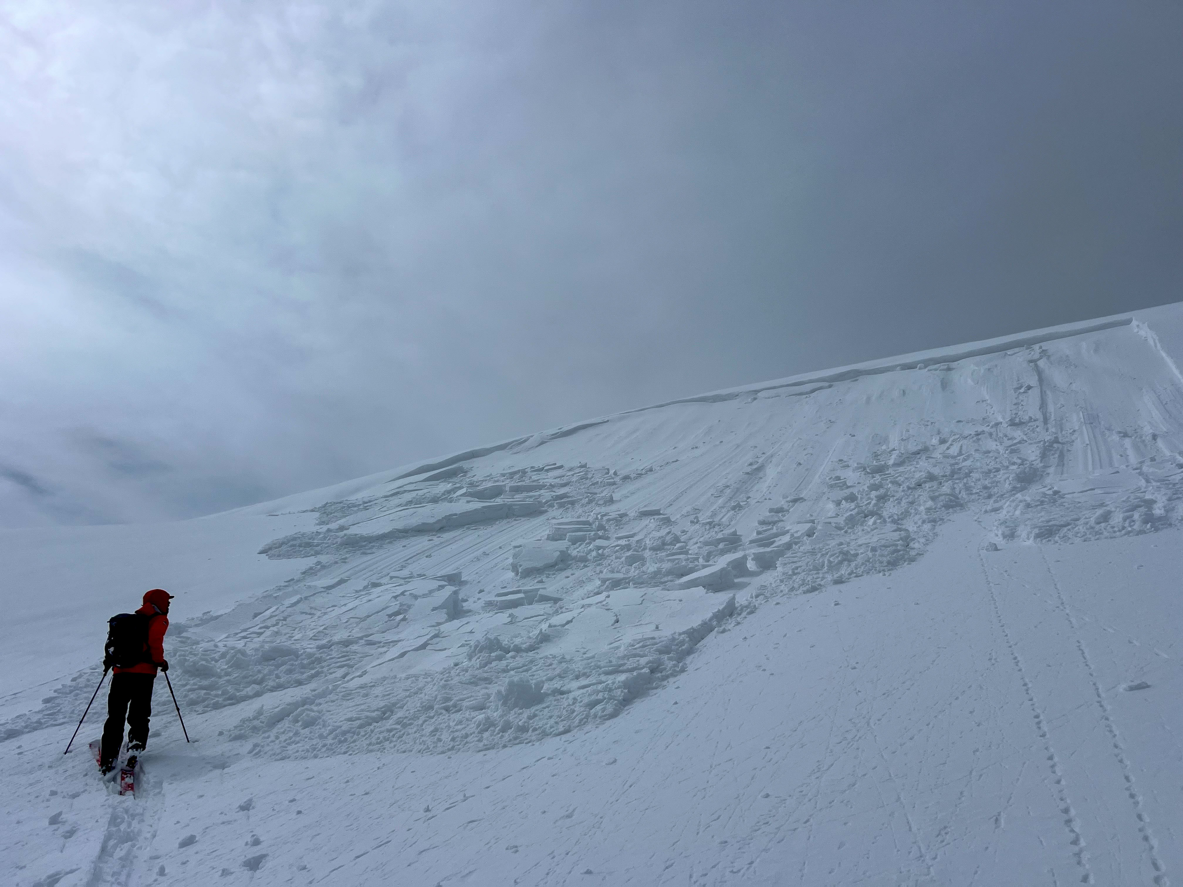
A southeast slope at 10k', where strong winds formed a stiff drift on the leeward side of a the ridge that failed about 50' wide and up to 3' deep. thanks Jen, for the original submission found, here!
*
Ad
Avalanche Problem #1
Wind Drifted Snow
Type
Location
Likelihood
Size
Description
Steady south and southwest winds have created new, and added volume to old wind-drifts, that are found at mid and upper elevations on the north half of the compass. These drifts are 1-3' deep and failing on the light-density snow that fell towards the tail end of the weekend storm. Yesterday, wind slabs failed naturally and were easlily triggered with the additional wieght of a human. Look for drifting in the usual suspect terrain just off ridges and cornices, along with more uncommon places like cross-loaded chutes, gullies and slope convexity's or rollovers. Keep your eyes peeled and avoid any fat, rounded pillow of snow that will be reactive to our additional weight and may pack more of a punch than you might expect.
A northeast slope at 10,200' off Duchesne ridge that avalanched naturally and fits the bill of the what I would expect to see windslabs look like today.
Avalanche Problem #2
Persistent Weak Layer
Type
Location
Likelihood
Size
Description
Several persistent weak layers of snow, now buried a couple feet from the snow surface, are beginning to show signs of maturity. In fact, the last reported persistent slab avalanche occurred last weekend in the high-country and seemed to be a bit of an outlier. As spring settles into place and our mindset on terrain shifts towards stepping onto bigger slopes, the fact is that colder, weak snow lingers in the middle of our snow pack and is hard to detect, but feels solid under our sled and skis. Unless you dig down and check it out, you may never know what it looks like. However, if you do some homework and trench down a bit you'll find weak, faceted snow buried 2' to 4’ deep beneath the snow surface -- The cause and culprit recent persistent slab avalanches.
Although it is mid-March, the snowpack is still quite complex. Persistent slab avalanches like the ones we are dealing with will end your day, or even worse... Let's keep it tight and avoid terrain where we could trigger a slide bigger than we bought into
Additional Information
  • We come to you with heavy hearts and great sadness this morning to confirm an avalanche accident on Friday, March 7th near Hoyt Peak, involving 51 year old Micheal Janulaitis from Marion, Utah. Micheal used a snowbike to access the terrain, but was caught, carried, and killed in an avalanche while skiing a steep, northeast facing run on Hoyt Peak.Huge thanks to the Department of Public Safety, Park City Mountain Resort and Canyons Village Snow Safety and Ski Patrol teams, along with Wasatch Backcountry Rescue for the hard work recovering Micheal and returning him to his family. Micheal was a friend of Utah Avy and we feel privileged for the time we got to spend together. This is a tremendous loss for our backcountry family and we will miss him deeply. We are compiling accident details and a preliminary report is available here.
General Announcements
We are always looking for snow and avalanche observations or just general riding conditions. In the meantime reach out to us with questions, concerns, or if you see anything in your travels! Contact us directly through the info below:
This forecast is from the U.S.D.A. Forest Service, which is solely responsible for its content. This forecast describes general avalanche conditions and local variations always occur. This forecast was issued on Monday, March 17th at 05:30 AM and expires 24 hours after it was issued.