Donate to Our Spring Campaign or Bid on our Spring Auction to Support Forecasting

Forecast for the Uintas Area Mountains

Craig Gordon
Issued by Craig Gordon on
Sunday morning, March 16, 2025
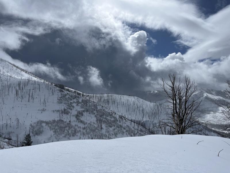
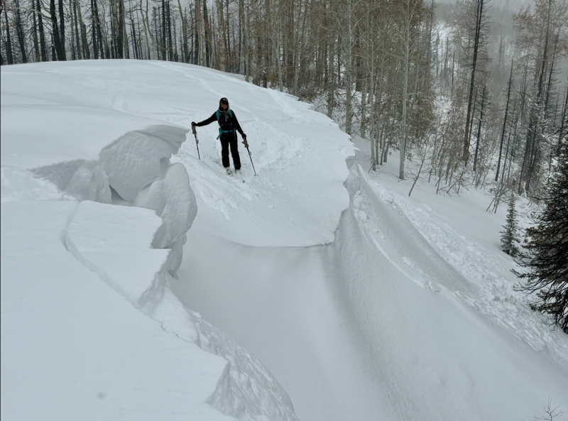
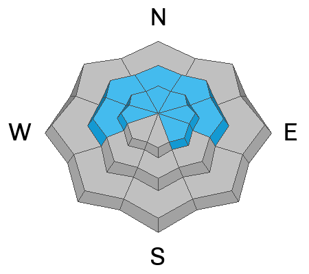
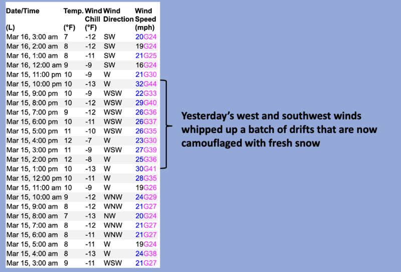
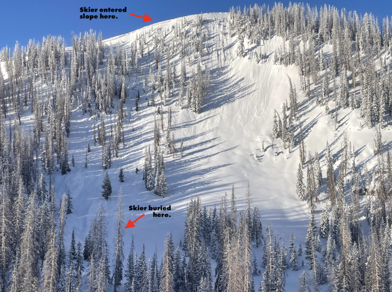
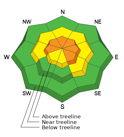
For today, CONSIDERABLE avalanche danger is found on upper elevation slopes, especially those facing the north half of the compass. In the windzone, at and above treeline, human-triggered fresh drifts and storm snow avalanches are LIKELY. Heads up... steep, rocky terrain with a shallow snowpack fits the bill for slopes that can produce an avalanche that fails on weak, midpack snow, delivering a slide that breaks deeper and wider than we might expect.
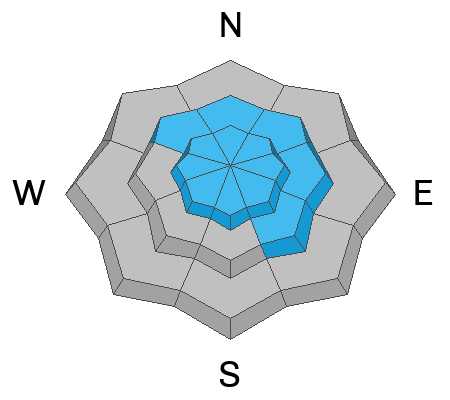
MODERATE avalanche danger exists in mid elevation terrain and human triggered avalanches are POSSIBLE on steep, wind drifted, shady slopes.
Most mid and lower elevation solars, along with low elevation polars offer dust on crust and generally LOW avalanche danger.
Low
Moderate
Considerable
High
Extreme
Learn how to read the forecast here
Special Announcements
Our Spring Campaign is in full swing, and there are two great ways to support forecasting, awareness, and education across Utah: Donate to our Spring Campaign or bid on items in our Spring Auction
Every dollar helps keep the backcountry community on top. Thank you for your support!
Weather and Snow
Nowcast- With partly cloudy skies overhead, cold air filters into the Uinta region and temperatures register in the teens at the trailheads and single digits near the peaks. Yesterday's stormy weather delivered a thin coat of white paint across the range with most areas receiving 3" of low density snow, while Trail Lake overachieved, piling up 6" of snow and about .40" H20. West and southwest winds bumped into the 30's right around suppertime, blew for nearly 10 hours in that spirit, before tapering off early this morning, delivering calm ridgetop winds for today's Sunday service.
Forecast- Prior to sunrise, a little wiggle of moisture clips northern Utah in the next few hours with a scattered snow shower or two, before skies clear yet again and deliver a partly cloudy day. West and southwest winds start the day in the reasonable category, but ramp into the 40's near the high peaks by midday, and then crank into the 50's and 60's by about dinnertime. Temperatures climb into the upper 30's today and dip into the mid 20's overnight.
Futurecast- Another winter storm is on tap for Monday, bringing a strong cold front through the area after sunset. The front ushers in a period of moderate to heavy snow, quickly stacking up 12" overnight before snow tapers off Tuesday afternoon.
Travel & Riding Conditions-
Ted was on the east side of the range and reports moody weather from Saturday. While Michael Davis and crew stomped around Bald Mountain and found similar weather and excellent riding conditions.
Recent Avalanches
Andy and his lovely partner Milan were in the Wolf Creek zone yesterday and report large corni, along with tender, yet predictable shallow drifts, very reactive to their additional weight.
Ad
Avalanche Problem #1
Persistent Weak Layer
Type
Location
Likelihood
Size
Description
For the moment, our problem children, several persistent weak layers of snow, now buried a couple feet from the snow surface, feel like they're becoming more comfortable in their own skin. In fact, we haven't seen or heard of any avalanches breaking to old snow in about a week... and that's good news. Sure, the pack feels bomber under our skis, board, or sled, however we gotta think not only about the snow we're riding in, but also the snow we're riding on. And while we might forget about weak layers, the snowpack has an amazing memory. Fact is... older, weak snow is hard to detect unless we dig down and investigate the layering. However, if you do a little homework and trench down a bit, you'll still find weak, sugary facets, now buried between 1' to 3’ deep beneath the snow surface and that's the devious culprit behind recent persistent slab avalanches.
The snowpack is becoming less cranky, though it's still quite complex, so let's keep it tight and avoid terrain where we could trigger a slide that breaks deeper and wider that what we might've bargained for. Think... steep, rocky, shallow... like slopes that have avalanched several times already this winter.
Avalanche Problem #2
Wind Drifted Snow
Type
Location
Likelihood
Size
Description
Above is a 24 hour data dump from Windy Peak (10,661'), illustrating yesterday's midday span of robust winds.
Increasing west and southwest winds whip up a batch of drifts that become more widespread and more reactive to our additional weight as the day wares on. I expect to see drifting in the usual suspect terrain like the leeward side of ridges and a few unusual places like cross-loaded chutes and gullies. In either case, continue to look for and avoid any fat, rounded pillow of snow which will react to our additional weight and may pack more of a punch than you might expect, especially by late in the day.
Additional Information
  • We come to you with heavy hearts and great sadness this morning to confirm an avalanche accident on Friday, March 7th near Hoyt Peak, involving 51 year old Micheal Janulaitis from Marion, Utah. Micheal used a snowbike to access the terrain, but was caught, carried, and killed in an avalanche while skiing a steep, northeast facing run on Hoyt Peak.Huge thanks to the Department of Public Safety, Park City Mountain Resort and Canyons Village Snow Safety and Ski Patrol teams, along with Wasatch Backcountry Rescue for the hard work recovering Micheal and returning him to his family. Micheal was a friend of Utah Avy and we feel privileged for the time we got to spend together. This is a tremendous loss for our backcountry family and we will miss him deeply. We are compiling accident details and a preliminary report is available here.
General Announcements
We are always looking for snow and avalanche observations or just general riding conditions. In the meantime reach out to us with questions, concerns, or if you see anything in your travels! Contact us directly through the info below:
This forecast is from the U.S.D.A. Forest Service, which is solely responsible for its content. This forecast describes general avalanche conditions and local variations always occur. This forecast was issued on Sunday, March 16th at 03:30 AM and expires 24 hours after it was issued.