Forecast for the Uintas Area Mountains

Craig Gordon
Issued by Craig Gordon for
Sunday, February 6, 2022
LOW avalanche danger blankets the danger rose and human triggered avalanches are unlikely on all aspects and elevations. While most terrain is good to go... pump the brakes for a second or two if you're stepping into a big, committing line and think about the consequences of triggering even a small avalanche that could knock you off your feet and instantly ruin your day.
Low
Moderate
Considerable
High
Extreme
Learn how to read the forecast here
Weather and Snow
NOWCAST-
High clouds drift through the region this morning as a pair of weak cold fronts slide overhead. Temperatures remained crisp overnight, bottoming out in the teens and single digits. Not that it's beanie wearing weather, but along the high ridges northerly winds blow 20-30 mph producing windchills to -15 degrees. Riding and turning conditions have gone from hero to zero, but in between the wind funk, suncrusts, and hard, old tracks you can still find patches of soft snow... though this weather pattern even has Edward Blizzard Hands seeking another line of work :).
FORECAST-
Look for intermittent morning clouds with northerly winds gusting into the 30's near the high peaks. Temperatures don't climb too much, only reaching into the upper 20's. Overnight lows dip into the teens.
FUTURECAST-
We are left high, dry, and warm through the week.
It's been a tough go lately and earlier this week, gusty north and northeast winds added insult to injury, especially above treeline where they pressed the snow into a teeth-chattering, bullet-proof surface. But don't let your heart be troubled... soft snow on wind and sun sheltered slopes is still out there, you just need to get a little creative. Earlier in the week, ace observer Michael J found a swath of soft, settled snow on a wind sheltered, lower elevation slope near Weber Canyon. His trip report and take on the current state of the snowpack is found HERE.

Looking for real-time temps, snow, or wind?
Click HERE and then on the "western Uinta" tab for western Uinta specific, weather station network.
Recent Avalanches
Ted was near Humpy Peak yesterday and found remnants of a natural wind slab, most likely triggered by cornice fall. Ted's trip report and always informative insight is found HERE
Otherwise, it's been rather quiet on the eastern front with no significant avalanche activity to report
Click HERE for a list of recent avalanches.
A list of all other observations is found HERE

Your input is vital and we're interested in what you're seeing. Please contribute to this great community resource and go here to fill out an observation.
Ad
Avalanche Problem #1
Normal Caution
Type
Location
Likelihood
Size
Description
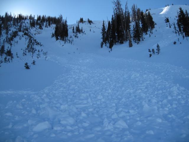
It's a given that snow-pros often talk in avalanche geek-speak, so it's no surprise you may ask yourself... what exactly does "Normal Caution" mean? Simply put, it means there's no specific avalanche problem to watch for, but we still need to be aware of our surroundings, be alert to changing weather conditions, and not let our guard down when we're in avalanche terrain. It also means we're carrying avalanche rescue gear, only exposing one person at a time to hazard when we're in avalanche terrain, and we're considering the consequences of triggering a slide, no matter how small, especially as we step up our big mountain terrain options.
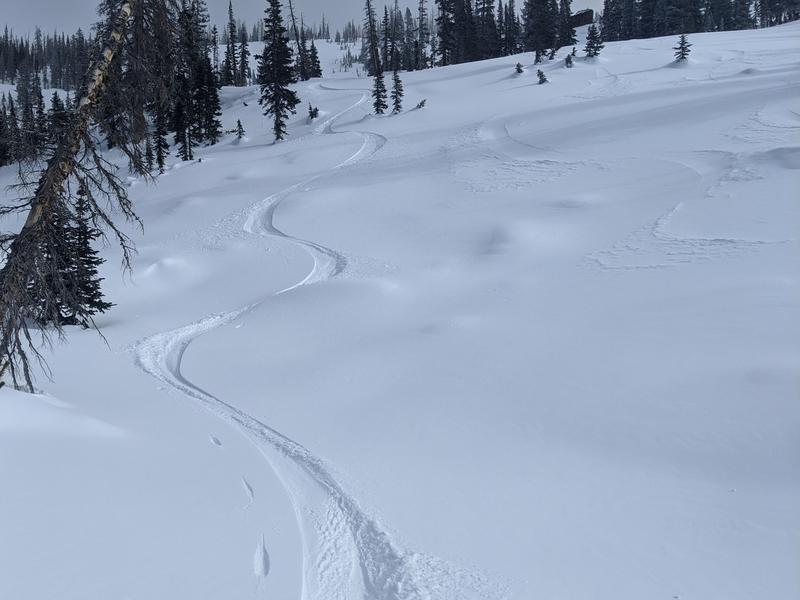
Since mountain travel always offers some hazards, it's worth watching out for them and considering ways to limit exposure to that threat. In terms of avalanches... there could be a few shallow, thin wind drifts that formed earlier in the week and again overnight which may grow large enough to knock us off our feet. For today, look for and avoid smooth, rounded, or pillowy textures to the snow surface and pieces of snow that sound hollow like a drum. In addition, remember that big, open terrain above treeline offers very hard snow and most south facing slopes have a hard ice crust on them. The main hazard on these slopes for skis, boards, or a sled is an uncontrollable slide for life... and that means- sliding downhill and not being able to stop.
Additional Information
While we're waiting patiently for winter to return from its hiatus, take a few minutes and visit one of our beacon parks and test your rescue skills. Ted installed a Beacon Basin at the Bear River Trailhead and there's another park found at the northeast corner of the Nobletts Trailhead.
Your observations are important, so please let me know what you're seeing... click HERE and contribute to this amazing community based program
General Announcements
The information in this forecast expires 24 hours after the day and time posted, but will be updated by 07:00 Monday February 7th.
Before it gets too crazy, now is the time to book an avalanche awareness presentation for your group, club, or posse. You can reach me directly at 801-231-2170 or [email protected]
This forecast is from the U.S.D.A. Forest Service, which is solely responsible for its content. This forecast describes general avalanche conditions and local variations always occur.