Forecast for the Uintas Area Mountains

Craig Gordon
Issued by Craig Gordon for
Saturday, February 3, 2024
Two types of avalanche dragon exist today with two very different characteristics and outcomes-
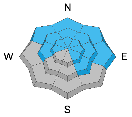
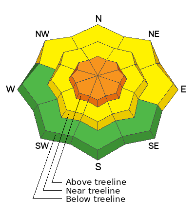
In the wind zone at and above treeline, fresh snow and recent winds deliver a CONSIDERABLE avalanche danger. Human triggered, fresh wind drifts are LIKELY on steep, leeward terrain around the compass. In addition, while becoming more the exception then the rule, a persistent, mid-pack weak layer, keeps CONSIDERABLE avalanche danger on our problem child radar. Human triggered avalanches breaking deeper and wider than you might expect are LIKELY, particularly on steep, rocky slopes facing the north half of the compass.
Lose a little elevation and you'll find a more straight-forward MODERATE avalanche danger with human triggered avalanches POSSIBLE on steep slopes with recent deposits of wind drifted snow.
LOW avalanche danger is found near the trailheads on slopes that face the south half of the compass.

Low
Moderate
Considerable
High
Extreme
Learn how to read the forecast here
Weather and Snow
Nowcast- "I'm gonna tell ya how it's gonna be.... you're gonna give your love to me". 64 years ago and rock n' roll will never be the same... the day the music died. Buddy Holly, Ritchie Valens, and "The Big Bopper" J. P. Richardson... RIP :(
Meanwhile, fresh powder and excellent riding conditions are alive and well. A band of thick clouds, coupled with colder air continues producing one last gasp of moisture, adding a few inches of low density, chin tickling snow to storm totals registering in the 10" range with just under an 1" of Snow Water Equivalent or SWE. Current temperatures register in the teens and low 20's while winds, blowing from the west and northwest are rather well-behaved, clocking in at 15-25 mph along the high ridges. Get out and get after it.... riding and turning conditions have gone from zero to hero.
Forecast- Look for mostly cloudy skies with a few more inches of snow stacking up, before snow turns showery, with clearing skies as the day wares on. Northwest winds remain reasonable, blowing in the mid 20's near the high peaks. Temperatures climb into mid 20's and overnight lows dip into the teens.
Futurecast- A break in the action is slated for Sunday, but another, more robust storm is coming in hot and should arrive Monday and linger through a good portion of the week.
Recent Avalanches
No significant avalanches to report.

Read more Uinta observations and avalanches HERE.
Ad
Avalanche Problem #1
Persistent Weak Layer
Type
Location
Likelihood
Size
Description
Inspired Summit Adventures owner and guide extraordinaire, snow-pro, and all around amazing human, Shaun Raskin demonstrates an extended column, snow stability test on an upper elevation shady slope in the western Uinta's. The results illustrate our reluctance to step out aimlessly into big terrain.
The good news is... the odds of triggering a slide on a persistent weak layer have decreased. Yeah, you'd really have to go out of your way to trigger a slide that breaks to older layers of snow today. However, fresh pow on a go-anywhere base, tends to steer us into bigger terrain, especially slopes in the wind zone.
The less than ideal news is... while so much of the range avalanched during the mid January storm cycle, a few slopes remain intact, just waiting for us to roll along, tickle the right spot, and collapse the snowpack, often around a rock or bush barely hidden under the snow. When it all comes together, it all comes apart and we'll be staring staring down a dangerous avalanche.
The flake news... if you choose to enter avalanche terrain and ride steep slopes, stack the odds in your favor. Avoid areas of thinner snow near rocks (sometimes hard to do), make sure the runout zone is free of trauma-inducing trees and rocks, and make sure your partners watch you from a safe area.
Avalanche Problem #2
Wind Drifted Snow
Type
Location
Likelihood
Size
Description
A 24 hour data dump from Windy Peak (10,661') shows both pre and post frontal winds and temps.
Fresh snow coupled with a good run of winds, whip up shallow drifts on the leeward side of mid and upper elevation ridges and cross-load terrain features like chutes and gullies. Starting from the south, but switching west and northwest, I bet you'll find fresh drifts sensitive to your additional weight. Easily managed with terrain choices.... simply look for and avoid fat, rounded pieces of snow, especially if they sound hollow like a drum.
Additional Information
Most SNOTEL sites have about average water content and snow now. Above is a graph from the Trial Lake SNOTEL showing the 30 year median (green line) and this year's precipitation (black line).
The Uinta weather station network was upgraded this summer and all that real-time info is found HERE. Simply click on "western Uinta" tab and then "weather stations" tab.

We are always looking for snow and avalanche observations or just general riding conditions. So... if you see something, say something. You can reach me directly at [email protected] or 801-231-2170.
Also, if you're looking for more avy education opportunities for yourself, your crew, or your club please don't hesitate to reach out to me and we'll find a presentation, class, or clinic for ya!
General Announcements

Issued at 0400 on Saturday, February 3rd this forecast will be updated by 0700 Sunday, February 4th, 2024.
This forecast is from the U.S.D.A. Forest Service, which is solely responsible for its content. This forecast describes general avalanche conditions and local variations always occur.