Forecast for the Uintas Area Mountains

Craig Gordon
Issued by Craig Gordon for
Sunday, February 3, 2019
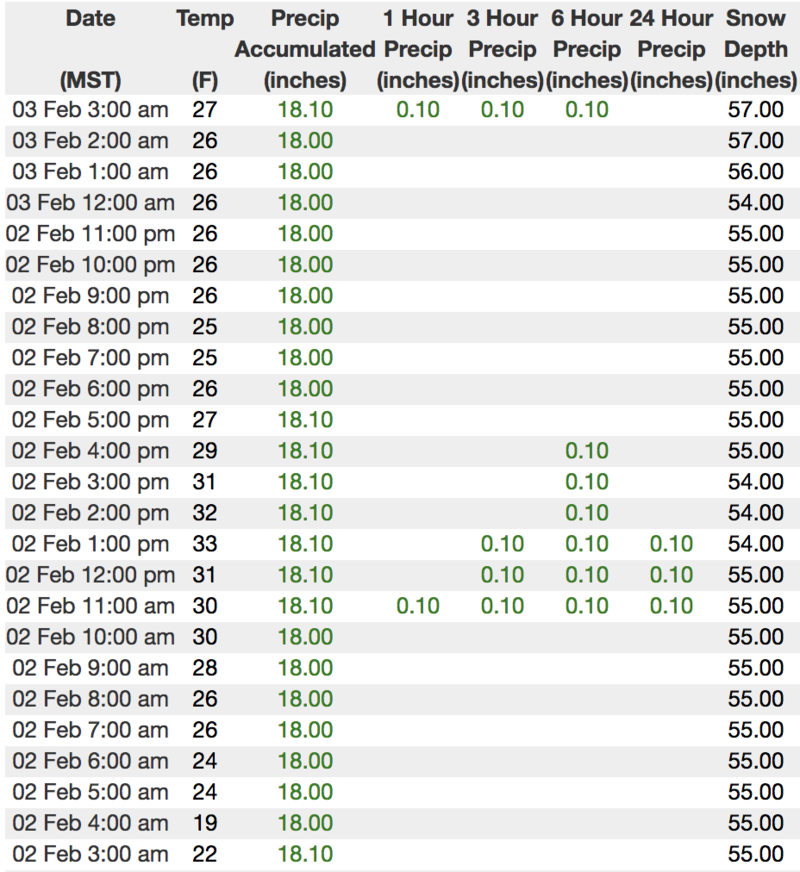
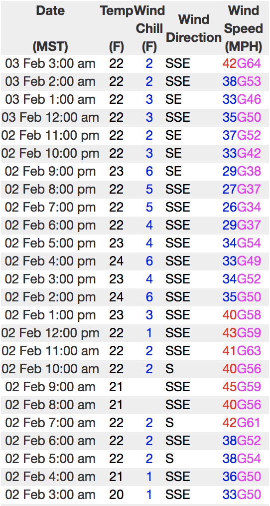
UNUSUAL AVALANCHE CONDITIONS MATERIALIZED OVERNIGHT-
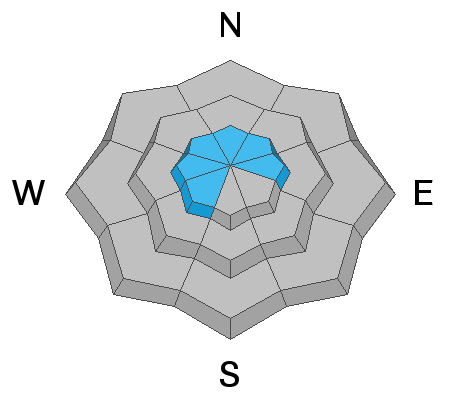
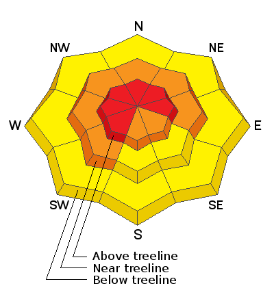
In the wind zone, at and above treeline, the avalanche danger is HIGH. Both human triggered and natural avalanches are LIKELY on steep wind drifted slopes, especially those facing the north half of the compass. Any avalanche that breaks into deeper buried weak layers near the ground will result in a scary and very dangerous avalanche that will instantly ruin your day.
You'll find CONSIDERABLE avalanche danger on steep, mid elevation, wind drifted slopes and human triggered avalanches are PROBABLE.
MODERATE avalanche danger exists on steep, low elevation terrain. Human triggered, wet snow avalanches are POSSIBLE where the pack is damp and manky.
Low
Moderate
Considerable
High
Extreme
Learn how to read the forecast here
Special Announcements
Weather and Snow
Under a band of thick clouds, a very warm, wet storm system is just starting to slide into the region. It looks like the upper elevations received 2" of dense, heavy snow overnight while the trailheads have a coating of wet, white glop. Temperatures are quite mild, in the 20's and low 30's. The big headline news this morning are the winds. Southerly winds have been cranking in the 30's and 40's along the high ridges for the past 24 hours, and currently blow 40-60 mph. Today's coat of fresh white paint isn't what makes our license plates famous, but it will add a cushion to the old hard tracks and crusts, softening the ride somewhat this morning.
Above is hourly data from Trial Lake (9,945') and Windy Peak (10,662'). To view more regional weather stations click here.
The eastern front lookin' mighty fine from a distance.... white and phat.
Recent Avalanches
A few shallow wind drifts reported from yesterday... otherwise no significant avalanche activity.
Recent trip reports and avy activity found HERE.
Ad
Avalanche Problem #1
Persistent Weak Layer
Type
Location
Likelihood
Size
Description
Strong winds and dense heavy snow will most likely reawaken dormant weak layers now buried several feet deep in our midpack.... and my bet is they're gonna be cranky when they wake up and come back to life. Our snowpack history reveals that each time there's a sufficient load of water weight, wind, and snow we see avalanches that break unmanageably wide and deep, often failing around our persistent midpack weakness. Today's weather is unusual for us and I'm not really sure what to make of it. What I do know is this.... unusual weather makes for unusual avalanches. So rather than just rolling the dice I'm going to make conservative terrain decisions and stick with low angle slopes with no steep terrain above or adjacent to where I'm riding.
JG was near Hoyt Peak earlier this week and here's his insight to our snowpack structure. "Pit tests were stubborn and somewhat inconclusive but I would be hard pressed to jump into steep terrain on the north half of the compass, especially if there is an easterly component to the slope. Things will be changing by the weekend and early next week with the addition of more water weight to the snowpack."
Sage advice from a seasoned snow pro. More on JG's travels are found here.
Avalanche Problem #2
Wind Drifted Snow
Type
Location
Likelihood
Size
Description
Fresh drifts formed on weak surface snow, similar to the snow in the video above, and I think today's drifts will easily react to our additional weight. While most prevalent on the leeward side of upper elevation ridges, wind will make up for lack of snow and sensitive drifts will also be found cross-loaded around terrain features like chutes, gullies, and sub-ridges.
Avalanche Problem #3
Wet Snow
Type
Location
Likelihood
Size
Description
Odd that we're talking about wet avalanches in the beginning of February... isn't it? However my gut tells me steep terrain at lower elevations may be prone to damp snow avalanches this morning. So if you're headed for a lower elevation trail run, snowshoe, or family outing you'll want to stay off of and out from steep snow covered terrain especially if the surface snow feels damp, saturated, or water logged.
Additional Information
A cold front passes through the region before dawn and winds should begin to relax somewhat. Snow showers continue through the day with a couple additional inches stacking up. High temperatures don't vary much from where we're at this morning. A colder storm is on tap for Tuesday and that should give us a good shot of snow.
General Announcements
The information in this advisory expires 24 hours after the date and time posted, but will be updated by 7:00 AM Monday February 4th, 2019.
If you're getting out and about, please let me know what you're seeing especially if you see or trigger and avalanche. I can be reached at [email protected] or 801-231-2170
It's also a good time to set up one of our very popular avalanche awareness classes. Reach out to me and I'll make it happen.
This information does not apply to developed ski areas or highways where avalanche control is normally done. This advisory is from the U.S.D.A. Forest Service, which is solely responsible for its content. This advisory describes general avalanche conditions and local variations always occur.