

Forecast for the Uintas Area Mountains

Issued by Craig Gordon on
Saturday morning, February 2, 2019
Saturday morning, February 2, 2019
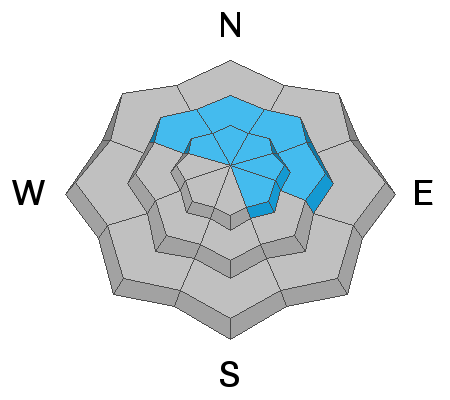
More the exception than the rule, but in the wind zone at and above treeline, you'll find MODERATE avalanche danger. Human triggered avalanches are POSSIBLE on steep wind drifted slopes, especially those facing the north half of the compass and particularly those with an easterly component to their aspect. Any avalanche that breaks into deeper buried weak layers near the ground will result in a scary and very dangerous avalanche that will instantly ruin your day.
LOW avalanche danger is found in lower elevation terrain, especially on slopes facing the south half of the compass. Human triggered avalanches are UNLIKELY.

Low
Moderate
Considerable
High
Extreme
Learn how to read the forecast here
 Special Announcements

 Weather and Snow
High, thin clouds are sliding through the region, temperatures are in the 20's, and southerly winds are blowing in the 40's and 50's, all ahead of a strong storm system slated to impact the region later today and tonight. The snow surface is a bit tired and worn out and could use a fresh coat of white paint. However amid the old tracks, wind board and sun funk, and with a little searching, you can still score soft creamy snow on wind sheltered, mid elevation slopes.
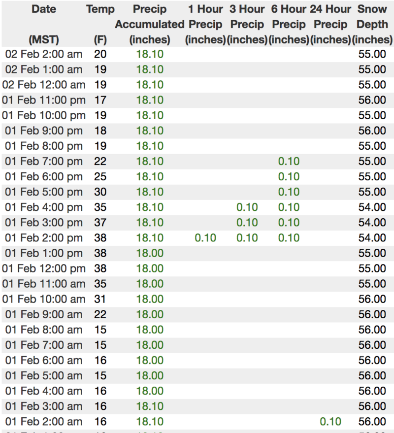

Above is hourly data from Trial Lake (9,945') and Windy Peak (10,662'). To view more regional weather stations click here.
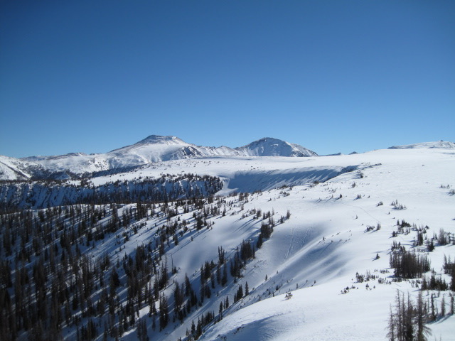
The eastern front lookin' mighty fine from a distance.... white and phat.

A closer look reveals great loud pow today, which may become tomorrow's problem child particularly if our forecasted storm buries and preserves this layer... something to keep an eye on.
 Recent Avalanches
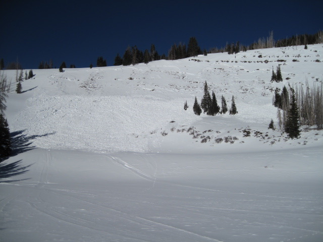
Ted noted, "A little unusual to see a slide on a southeast aspect this time of year. A day or two old and possibly triggered from near the bottom of the slope, it is not a very deep slide but roughly 300' wide."
BUT WAIT... THERE'S EVEN MORE AVY ACTIVITY FOUND HERE.

Avalanche Problem #1
Persistent Weak Layer
Type
Location
Likelihood
Size
Description
As the snowpack slowly becomes comfortable in its own skin, avalanches are becoming more stubborn and harder to trigger.... good news! And there are plenty of slopes to ride and not trigger avalanches.... better news! However, the problem with persistent weak layers in the snowpack is they linger for long periods of time and often suggest a false sense of snow stability because the snow will feel solid and stable under our skis, board, or sled. But remember, all it takes is for us to find one weakness on the slope, perhaps where it's thin like by a rock or bush we can't see under the snow, collapse the pack, and now all bets are off.... we're staring down the barrel of a dangerously, unmanageable slide.
Of course you wanna know... "how do we manage an unmanageable avalanche?" Well with all the great riding out there and plenty of alternative options, we simply avoid the terrain where it exists. You know the drill by now.... steep, rocky, wind drifted slopes, especially those facing the north half of the compass. Listen to this groups decision making process here.
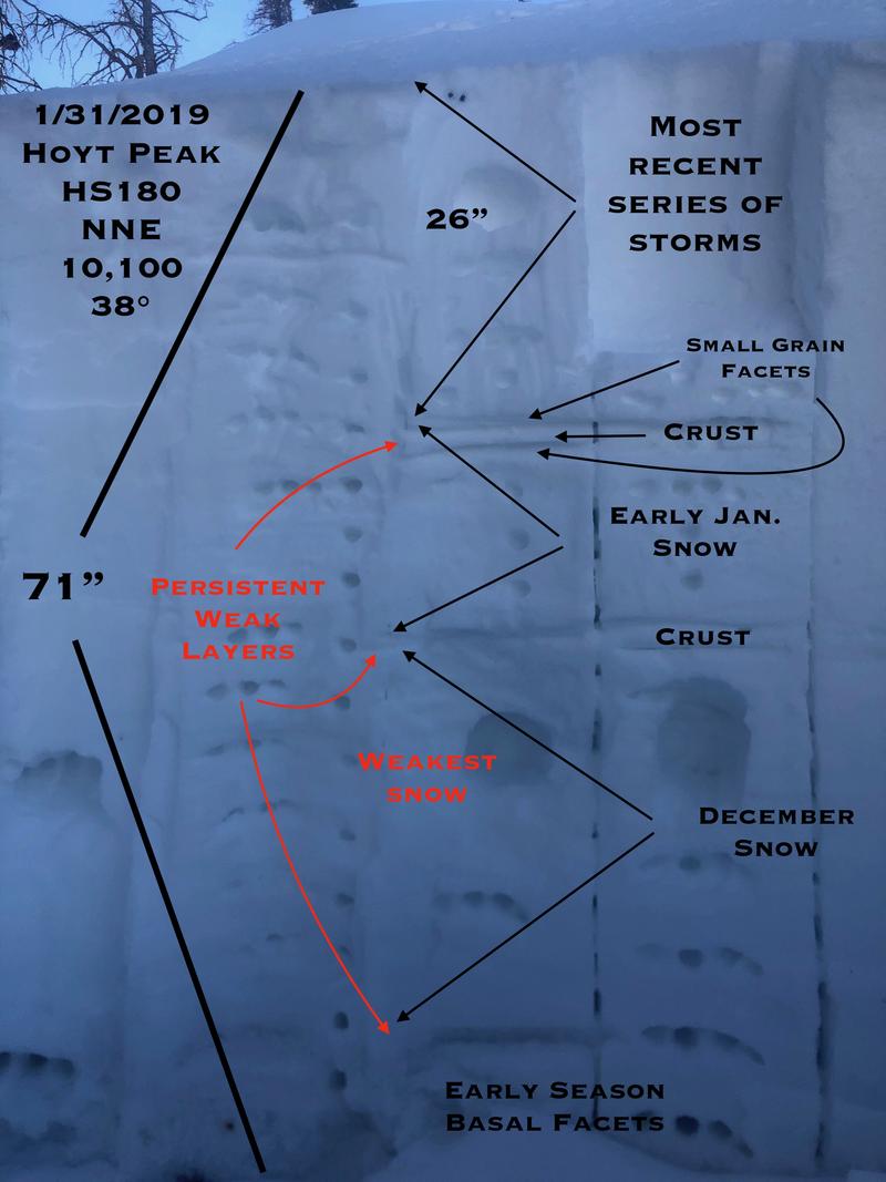
JG was near Hoyt Peak yesterday and here's his insight to our snowpack structure. "Pit tests were stubborn and somewhat inconclusive but I would be hard pressed to jump into steep terrain on the north half of the compass, especially if there is an easterly component to the slope. Things will be changing by the weekend and early next week with the addition of more water weight to the snowpack."
Sage advice from a seasoned snow pro. More on JG's travels are found here.
Avalanche Problem #2
Wind Drifted Snow
Type
Location

Likelihood
Size
Description
As the storm materializes and snow begins to stack up late in the day, remember it'll fall on weak surface snow and fresh drifts will be tender, easily reacting to our additional weight. Mostly manageable today, I suspect that by this time tomorrow wind drifts will become more widespread and connected.
Additional Information

While mostly a southern Utah storm to begin with, moisture eventually drifts north and we should see snow begin to materialize late in the day. Prior to the storms arrival we can expect temperatures climbing into the mid 30's and southerly winds cranking into the 50's and 60's along the ridges. Light snow develops late this afternoon and becomes more robust overnight.... 6"-10" by morning seems reasonable.
General Announcements
The information in this advisory expires 24 hours after the date and time posted, but will be updated by 7:00 AM Sunday February 3rd, 2019.
If you're getting out and about, please let me know what you're seeing especially if you see or trigger and avalanche. I can be reached at [email protected] or 801-231-2170
It's also a good time to set up one of our very popular avalanche awareness classes. Reach out to me and I'll make it happen.
This information does not apply to developed ski areas or highways where avalanche control is normally done. This advisory is from the U.S.D.A. Forest Service, which is solely responsible for its content. This advisory describes general avalanche conditions and local variations always occur.