Forecast for the Uintas Area Mountains

Issued by Craig Gordon on
Friday morning, February 1, 2019
Friday morning, February 1, 2019
WHILE BECOMING HARDER TO TRIGGER.... TRICKY AVALANCHE CONDITIONS STILL EXIST ON THE EASTERN FRONT
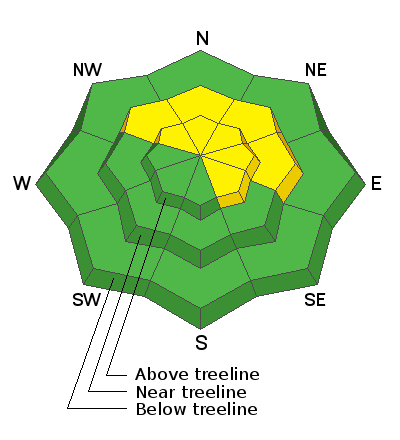
More the exception than the rule, in the wind zone at and above treeline, you'll find MODERATE avalanche danger. Human triggered avalanches are POSSIBLE on steep wind drifted slopes, especially those facing the north half of the compass and particularly those with an easterly component to their aspect. Any avalanche that breaks into deeper buried weak layers near the ground will result in a scary and very dangerous avalanche that will instantly ruin your day.
LOW avalanche danger is found in lower elevation terrain, especially on slopes facing the south half of the compass. Human triggered avalanches are UNLIKELY.
Low
Moderate
Considerable
High
Extreme
Learn how to read the forecast here
 Special Announcements
 Weather and Snow
Above the building valley haze and gunk, clear skies and clean air is found in the mountains. Currently, temperatures are in the teens and low 20's. Winds switched to the southwest overnight and blow 10-20 mph along the high peaks. The snow surface could use a fresh coat of white paint, however amid the old tracks, wind board and sun funk, and with a little searching, you can still score soft creamy snow on wind sheltered, mid elevation slopes.

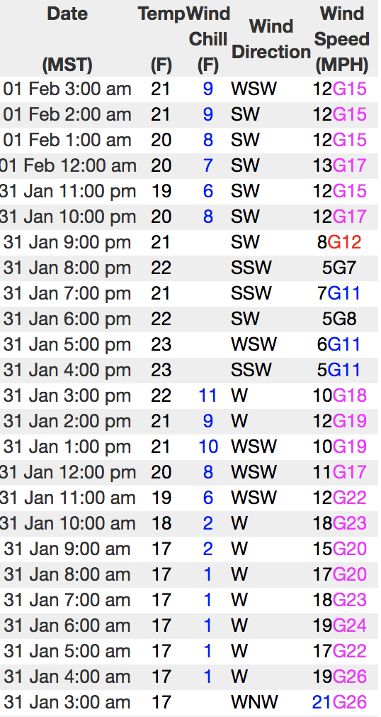
Above is hourly data from Trial Lake (9,945') and Windy Peak (10,662'). To view more regional weather stations click here.
 Recent Avalanches
The last in a long string of human triggered slides occurred on Tuesday wrapping up a very busy week in the western Uinta's where a handful of large, snowmobile and skier triggered slides, resulted in a wrecked sled and few close calls.

Dave and Pete thumped this upper elevation, northwest facing slope Tuesday, getting it to fail on early season facets and breaking 2'-4' deep and about 200' wide.
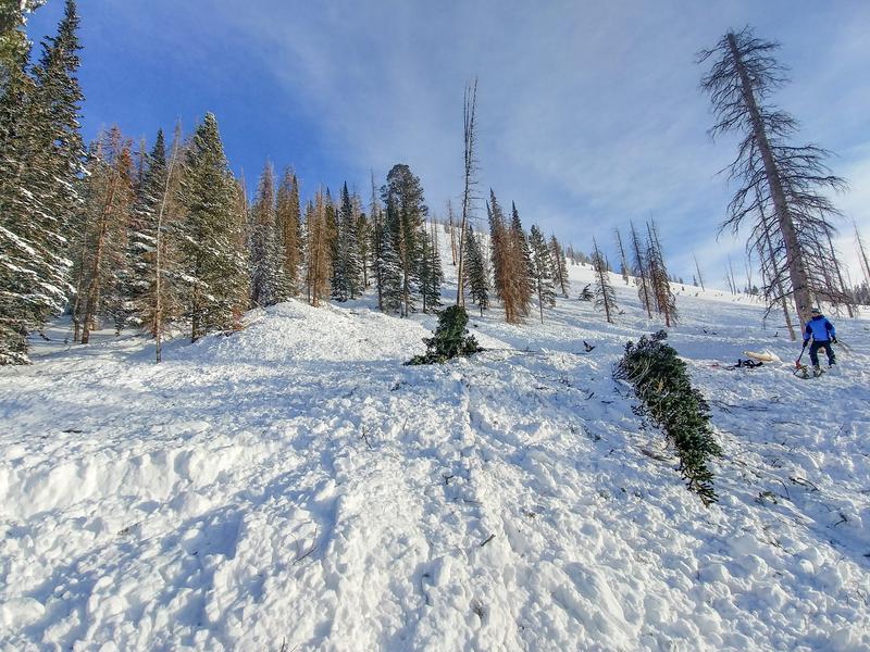
3' deep and 50' wide, this skier triggered pocket Monday near the Boundary Creek Yurt was smaller than recent human triggered slides. But you can clearly see by the snapped timber, this avy was packing a punch and meant business.
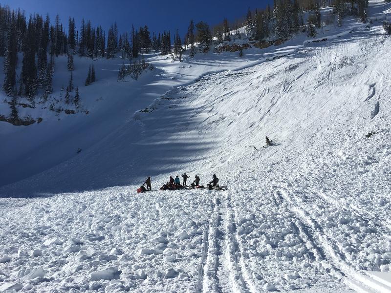
4' feet deep and 500' wide, the slide above was triggered Sunday near Hoyt Peak. We are of course happy everyone came out unscathed, but we're running out of luck, and there's not many empty chambers left.
BUT WAIT... THERE'S EVEN MORE AVY ACTIVITY FOUND HERE.
Avalanche Problem #1
Persistent Weak Layer
Type
Location
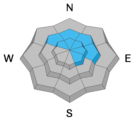
Likelihood
Size
Description
As the snowpack slowly becomes comfortable in its own skin, avalanches are becoming more stubborn and harder to trigger.... good news! And there are plenty of slopes to ride and not trigger avalanches.... better news! However, the problem with persistent weak layers in the snowpack is they linger for long periods of time and often suggest a false sense of snow stability because the snow will feel solid and stable under our skis, board, or sled. But remember, all it takes is for us to find one weakness on the slope, perhaps where it's thin like by a rock or bush we can't see under the snow, collapse the pack, and now all bets are off.... we're staring down the barrel of a dangerously, unmanageable slide.
Of course you wanna know... "how do we manage an unmanageable avalanche?" Well with all the great riding out there and plenty of alternative options, we simply avoid the terrain where it exists. You know the drill by now.... steep, rocky, wind drifted slopes, especially those facing the north half of the compass. Listen to this groups decision making process here.
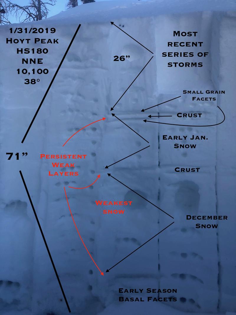
JG was near Hoyt Peak yesterday and here's his insight to our snowpack structure. "Pit tests were stubborn and somewhat inconclusive but I would be hard pressed to jump into steep terrain on the north half of the compass, especially if there is an easterly component to the slope. Things will be changing by the weekend and early next week with the addition of more water weight to the snowpack."
Sage advice from a seasoned snow pro. More on JG's travels are found here.
Avalanche Problem #2
Wind Drifted Snow
Type
Location

Likelihood
Size
Description
Mostly tired, lifeless, and welded in place there may still be a terrain driven wind drift or two lurking along the leeward side of an upper elevation ridgeline. Remember to avoid any fat, rounded piece of snow especially if it sounds hollow like a drum. And finally the hugest clue... recent avalanches on the same kind of terrain you want to ride on.
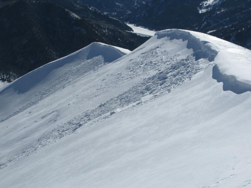
A recently windloaded, upper elevation northeast facing slope, reacted to my additional weight Tuesday. Not particularly large, but the results provides me a baseline to the type of terrain I wanna ride.
Additional Information

One last sunny day with temperatures warming into the mid and upper 30's. Southwest winds ramp up later today and should blow in the 40's by about dinner time. A warm storm system kicks off the weekend with valley rain and mountain snow developing on Saturday. Winds crank and a couple inches of dense heavy snow stacks up late in the day. Colder air filters into the region Sunday and snow totals should ramp up rather quickly. This is lining up to be a good storm for the eastern front.
General Announcements
The information in this advisory expires 24 hours after the date and time posted, but will be updated by 7:00 AM Saturday February 2nd, 2019.
If you're getting out and about, please let me know what you're seeing especially if you see or trigger and avalanche. I can be reached at craig@utahavalanchecenter.org or 801-231-2170
It's also a good time to set up one of our very popular avalanche awareness classes. Reach out to me and I'll make it happen.
This information does not apply to developed ski areas or highways where avalanche control is normally done. This advisory is from the U.S.D.A. Forest Service, which is solely responsible for its content. This advisory describes general avalanche conditions and local variations always occur.


