Forecast for the Uintas Area Mountains

Craig Gordon
Issued by Craig Gordon on
Thursday morning, February 27, 2025
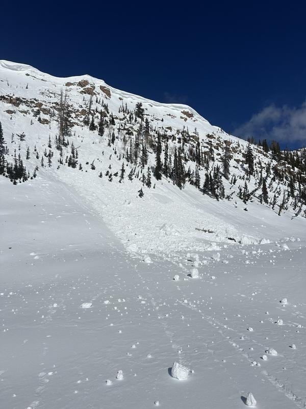
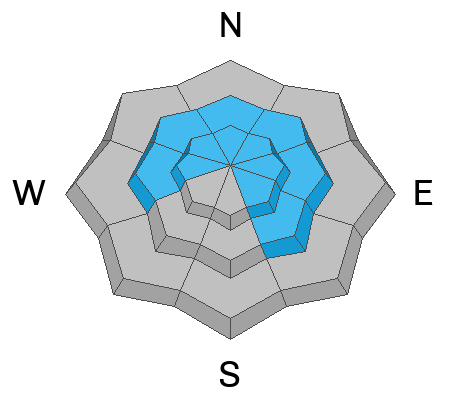
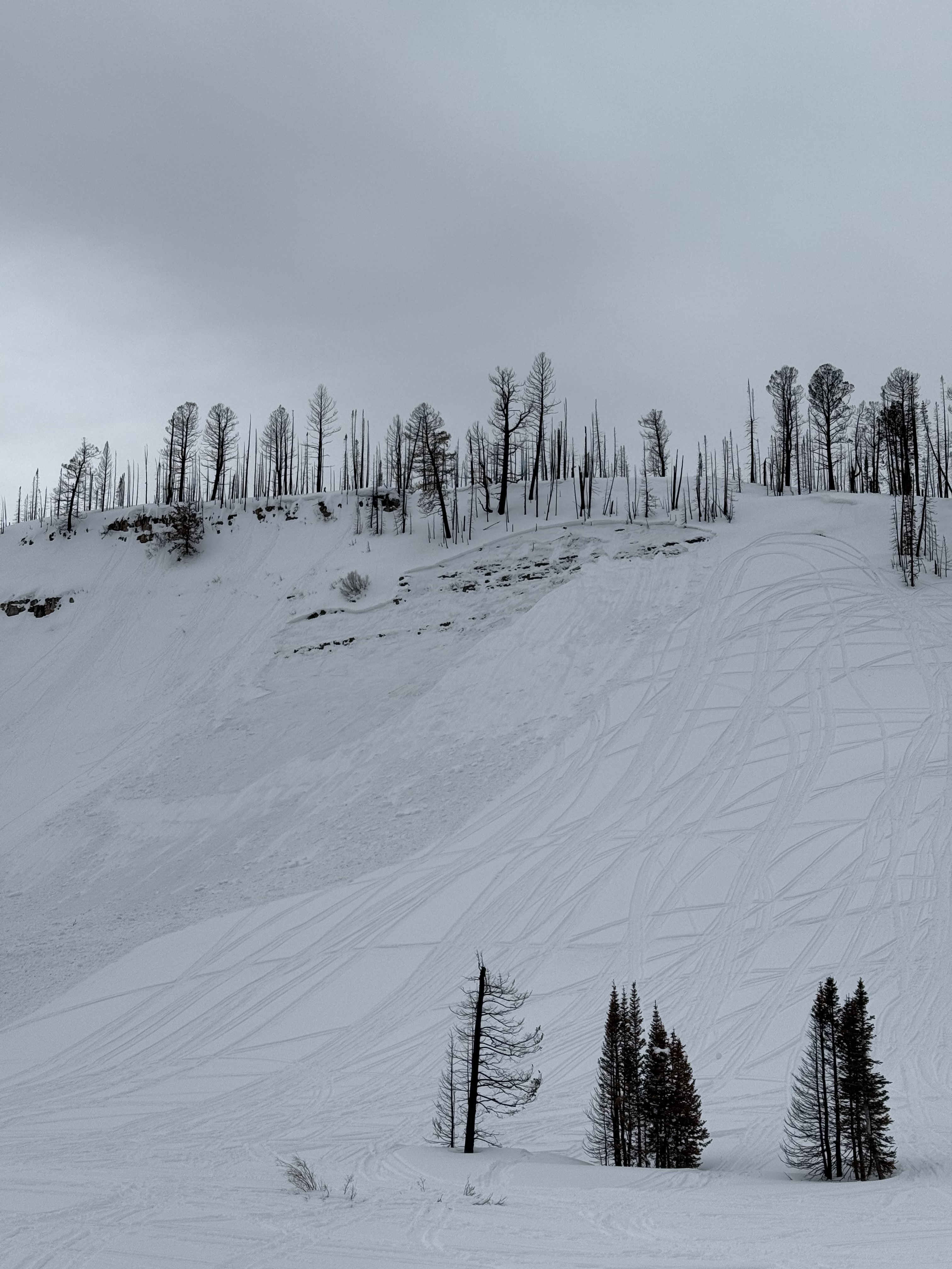
We're not out of the woods yet and can still expect CONSIDERABLE avalanche danger at and above treeline on steep slopes facing the north half of the compass where human triggered avalanches, breaking 3'-6' deep and failing on faceted snow near the ground are LIKELY. A bit more straightforward, though still packing a punch, mid elevation terrain offers MODERATE avalanche danger and human triggered avalanches are POSSIBLE on steep, shady slopes with a shallow snowpack. In either case, it's not as touchy as the past few days, but any slide triggered will break deeper and wider than you might've bargained for.
In addition... a handful of tired, old, hard drifts linger in the windzone and you'll find MODERATE avalanche danger on steep, leeward slopes where human triggered wind slabs are POSSIBLE.
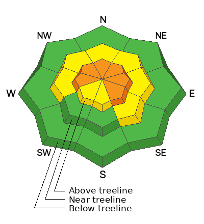
Low
Moderate
Considerable
High
Extreme
Learn how to read the forecast here
Special Announcements
We are excited to announce the launch of our new mobile application available on both Android and IOS. Get all the information you need to plan your backcountry adventure and keep the information at the tip of your fingers while you are out. Install the Android version here and the IOS version here.
Weather and Snow
Nowcast- With clear skies overhead, temperatures are inverted, registering in the single digits at the trailheads and in the mid 20's near the ridges. North and northeast winds blow 10-20 mph near the high peaks. Recent temperature whiplash had its way on the snow surface and riding conditions are sorta hit or miss. But don't let your hearts be troubled, swaths of soft snow are still found on mid and upper elevation, wind sheltered shady slopes or simply switch aspects and harvest some lower elevation corn on the sunnies. In either case... getting there is a bit rugged.
Forecast- It'll be a stunning day with mostly sunny skies and temperatures warming into the low 40's. Northerly winds remain reasonable, blowing in the teens near the high peaks. Overnight lows dip into the low 20's.
Futurecast- A weak and mostly dry impulse brushes by the region late in the weekend, delivering little to no moisture. The pattern takes a turn for better and wetter early Monday through Wednesday as a stronger looking system settles into northern Utah. Deets are hazy, but we'll narrow it down for ya in the next few days.
Please have patience while we re-calibrate weather systems... we will return to your regularly scheduled powder program next week :)
Recent Avalanches
DJ Osborne was riding near Hourglass Lake and discovered this large piece of cornice that tumbled downhill sometime yesterday.
No shortage of recent avalanches this weekend. From the North Slope to the south half of the range, multiple, human triggered slides were reported, ending with a close call near the Buck Knoll. Check out the great video and detailed report, here -- thanks for sharing!
In addition, check out intel from across the range and beyond, here.
Ad
Avalanche Problem #1
Persistent Weak Layer
Type
Location
Likelihood
Size
Description
We stomped around treeline Tuesday and found weak layers getting a little more stubborn, yet still reactive to our stability tests.
The calendar might suggest we're rounding out February and turning the corner into March Madness, but the snowpack feels and looks similar to what we usually see in mid January. So, if the snowpack is running a month behind, I need to realign my mindset to the cold, dark days near the turn of the New Year, and continue to pump the brakes and gather as much intel as I can. When I look under the hood I realize our snow structure is tricky, it's complicated, and it's harboring multiple layers of faceted snow. Indeed, we've got a complex snowpack that feels deceivingly solid underfoot, but really showed its personality last weekend once we kicked the legs out from underneath. In fact, riders confirmed our theories, triggering numerous and notable slides, failing on a host of problematic weak layers, now buried 2-4' beneath the snow surface.
Here's the conundrum... we're not seeing the usual red flags like cracking and collapsing, but recent avalanches are natures freebie and the biggest red flag. So how do we manageable an unruly avalanche dragon? Simply steer clear of it and instead opt for non-avalanche terrain with no overhead hazard. Done and done!
This avalanche from Soapstone Mountain broke on a shallow, rocky, east facing slope at 9,800'. Tracks on a slope don't mean it's good to go. Whether it's on the first pull or the hundredth, all we need to do is find the sweet spot like near a bush or shallowly buried rock, collapse the pack (whoomph) and now we're off to the races with the roof crashing down on us.
Avalanche Problem #2
Wind Drifted Snow
Type
Location
Likelihood
Size
Description
Today's wind drifts are stubborn and largely welded in place, but remember.... even a small piece of snow can quickly knock us off our feet, and boss us around, resulting in a body-brusing ride in sustained steep terrain. If you're stepping out and tagging big slopes have an exit strategy planned. While this is a straight-forward avalanche problem, you'll still need to be on your toes and continue looking for and avoiding fat, rounded pillows of snow and listen for slopes that sound hollow like a drum.
General Announcements
We are always looking for snow and avalanche observations or just general riding conditions. In the meantime reach out to us with questions, concerns, or if you see anything in your travels! Contact us directly through the info below:
This forecast is from the U.S.D.A. Forest Service, which is solely responsible for its content. This forecast describes general avalanche conditions and local variations always occur. This forecast was issued on Thursday, February 26th at 03:30 AM and expires 24 hours after it was issued.