Forecast for the Uintas Area Mountains

Craig Gordon
Issued by Craig Gordon on
Friday morning, February 28, 2025
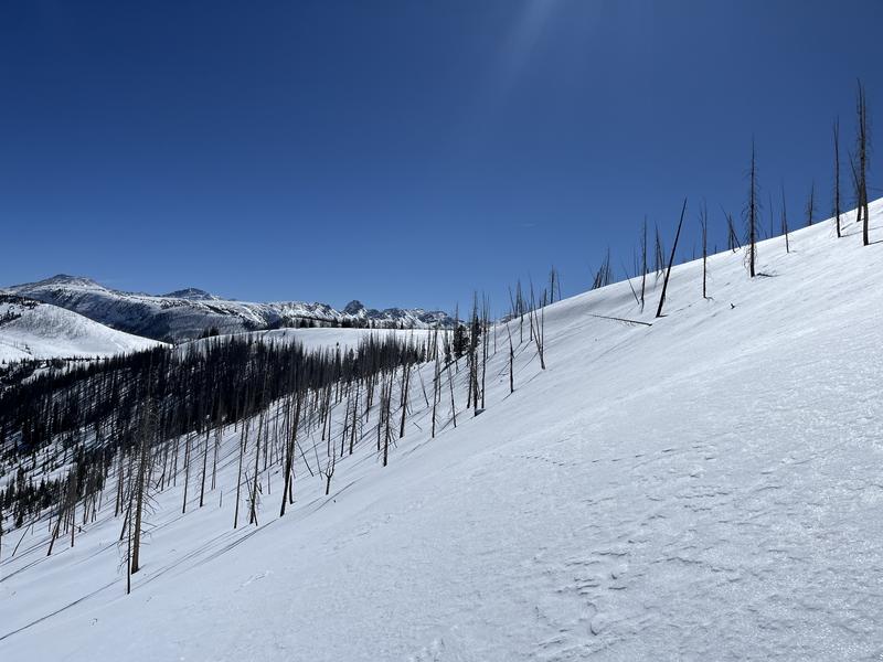
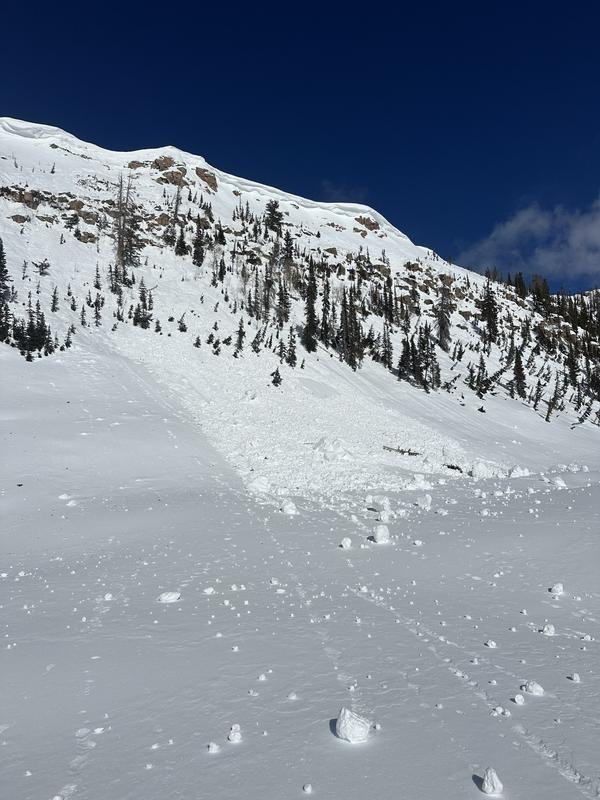
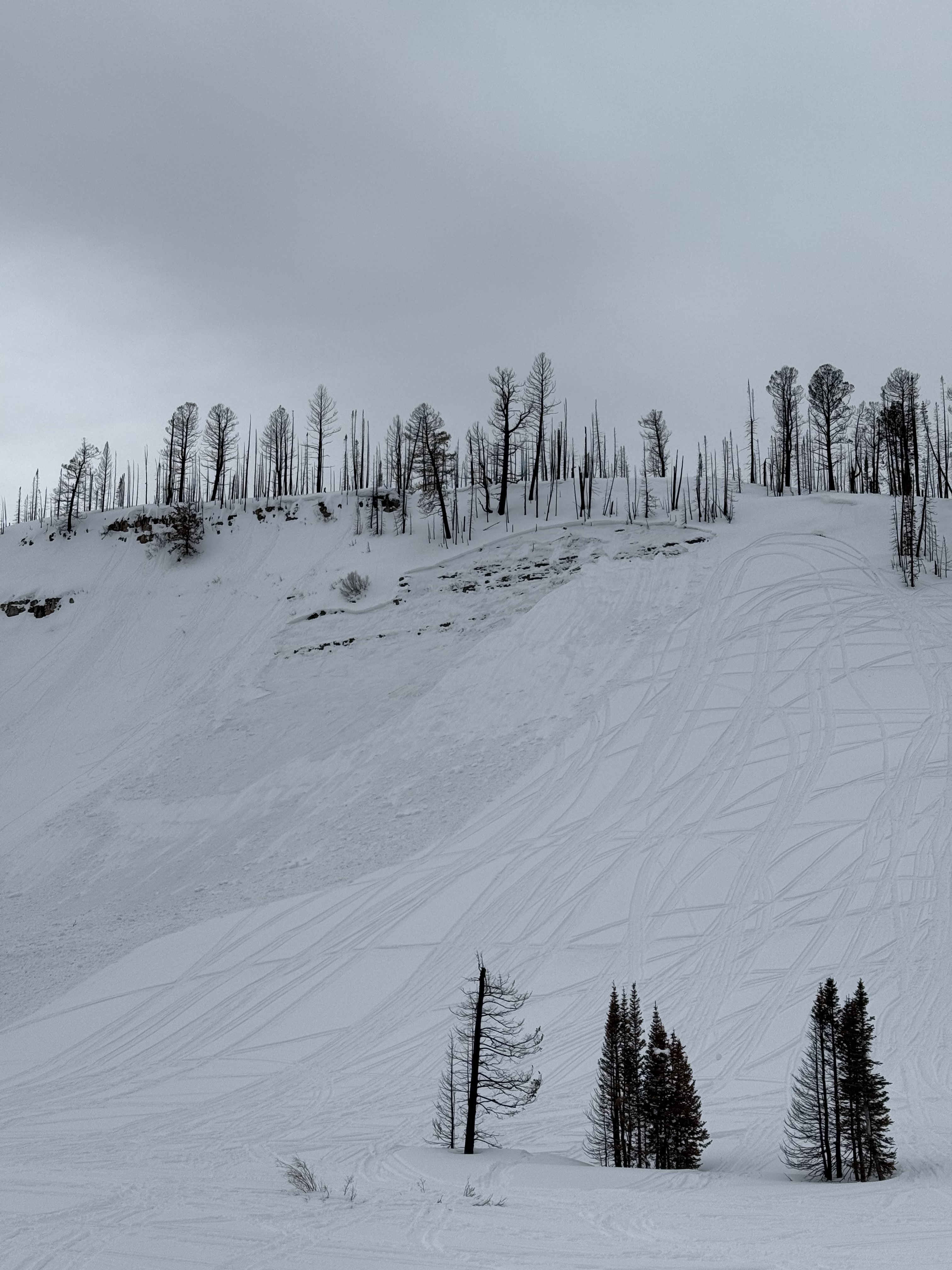
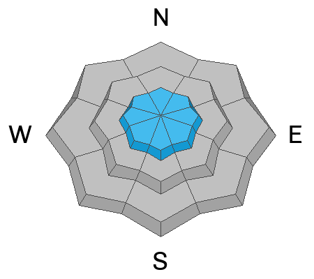
MODERATE avalanche danger is found at and above treeline, especially in the windzone on steep, rocky slopes facing the north half of the compass. Human triggered avalanches are POSSIBLE particularly where dense snow overlays a variety of sugary, weak layers. Remember... any avalanche that fails on old snow is gonna throw a wicked curveball at your day, delivering a slide that breaks deeper and wider than you might've bargained for.
LOW avalanche danger is found on lower elevation terrain around the dial and human triggered avalanches are UNLIKELY.
Low
Moderate
Considerable
High
Extreme
Learn how to read the forecast here
Special Announcements
We are excited to announce the launch of our new mobile application available on both Android and IOS. Get all the information you need to plan your backcountry adventure and keep the information at the tip of your fingers while you are out. Install the Android version here and the IOS version here.
Join the UAC on Thursday, March 6th at Brewvies in Salt Lake for friends, drinks, prizes, and an action-packed film! Alpine Assassins is a movie about incredible backcountry sledding and adventure. Doors open at 6:30 PM. Get your tickets here.
Weather and Snow
Nowcast- High pressure delivers clear skies, light northerly winds, and a rather strong temperature inversion with the mercury starting its day in the mid 20's near the trailheads while hovering closer to 30 degrees along the high ridges. No new snow in a week equates to some rugged conditions, but swaths of soft snow are still found on mid and upper elevation, wind sheltered, shady slopes. Switching aspects to lower and mid elevation sunnies yields a ripening, late morning corn crop. In either case, it might not be premiere riding and sliding at the moment, but a fair day in the mountains beats a great day collecting receipts for tax day.
Forecast- A couple beautiful days are on tap with mostly sunny skies and temperatures climbing into the 40's while overnight lows dip into the mid 20's. Winds remain light and northerly, blowing just 10-20 mph near the high peaks.
Futurecast- Sunday brings increasing clouds and wind with a winter storm expected to impact Utah's northern mountains from early Monday through Tuesday night. Southwest flow for Monday favors the south half of the range, while cold, northwest flow helps the North Slope from Tuesday into early Wednesday. A foot of snow and an inch of H20 feels like reasonable storm totals.
Ted visited the Mill Creek zone yesterday... "Still finding quite nice snow, but the band of soft settled snow is getting a little narrow."
Recent Avalanches
DJ Osborne was riding near Hourglass Lake and discovered this large piece of cornice that tumbled downhill sometime Wednesday.
No shortage of recent avalanches this weekend. From the North Slope to the south half of the range, multiple, human triggered slides were reported, ending with a close call near the Buck Knoll. Check out the great video and detailed report, here -- thanks for sharing!
In addition, check out intel from across the range and beyond, here.
Ad
Avalanche Problem #1
Persistent Weak Layer
Type
Location
Likelihood
Size
Description
We stomped around treeline Tuesday and found weak layers getting a little more stubborn, yet still reactive to our stability tests.
Let's face it.... our snowpack is complicated. And though the calendar suggests we're rounding out February and turning the corner into March Madness, the snowpack feels and looks similar to what we usually see in mid January. When I look under the hood I see a tricky snow structure that's complicated and harboring multiple layers of faceted snow. But rather than getting deep in the weeds of snow-geek speak, I turn my attention to the type of terrain that feels sketchy to me and it fits into a couple distinct hoppers. Slopes that have avalanched several times this season (repeaters) or terrain that's remained thin from lack of snow are in the bulls-eye. In fact, these are exactly the types of slopes where we've seen recent avalanche activity. When snowpack is the question... terrain is the answer. I'm in it for the long haul, so I'm simply avoiding steep, shady slopes that look thin and rocky, or still have bushes poking through the snow.
From last weekend an avalanche from Soapstone Mountain breaking on a shallow, rocky, east facing slope at 9,800'. Tracks on a slope don't mean it's good to go. Whether it's on the first pull or the hundredth, all we need to do is find the sweet spot like near a bush or shallowly buried rock, collapse the pack (whoomph) and now we're off to the races with the roof crashing down on us.
Avalanche Problem #2
Wind Drifted Snow
Type
Location
Likelihood
Size
Description
Today's wind drifts are stubborn and largely welded in place, but remember.... even a small piece of snow can quickly knock us off our feet, and boss us around, resulting in a body-brusing ride in sustained steep terrain. If you're stepping out and tagging big slopes have an exit strategy planned. While this is a straight-forward avalanche problem, you'll still need to be on your toes and continue looking for and avoiding fat, rounded pillows of snow and listen for slopes that sound hollow like a drum.
General Announcements
We are always looking for snow and avalanche observations or just general riding conditions. In the meantime reach out to us with questions, concerns, or if you see anything in your travels! Contact us directly through the info below:
This forecast is from the U.S.D.A. Forest Service, which is solely responsible for its content. This forecast describes general avalanche conditions and local variations always occur. This forecast was issued on Friday, February 28th at 03:30 AM and expires 24 hours after it was issued.