Forecast for the Uintas Area Mountains

Mark Staples
Issued by Mark Staples for
Friday, February 25, 2022
Today the avalanche danger is MODERATE above treeline where soft slabs of wind drifted snow can be triggered. These wind slabs may be 1.5 feet deep and 100 feet wide. The good news is that they aren't too widespread and are easy to avoid.
Near and below treeline where winds haven't drifted snow, the avalanche danger is LOW and human triggered avalanches are unlikely.
Low
Moderate
Considerable
High
Extreme
Learn how to read the forecast here
Weather and Snow
NOWCAST-
Even though there hasn't been a major storm, new snow has been trickling in through this week, and it's starting to feel deep, especially on northerly facing, wind-sheltered slopes where the new snow rests on soft, faceted snow. This morning, cloudy skies delivered an inch of new snow bringing this week's snow total to about 7 inches.
Very cold temperatures are the main story this morning. Most weather stations in the Uintas are reporting temperatures of -8 to -1 degrees F. The good news is that winds from the southwest aren't too strong and are averaging 6-10 mph gusting to 15 mph.
FORECAST-
Today will remain cloudy and cold with temperatures struggling to climb above 0 degrees F and into the single digits. Winds will switch direction and blow from the north but will be light with the strongest wind speeds this morning. There should be some snow flurries today and perhaps another inch of new snow will accumulate.
FUTURECAST-
High pressure arrives tonight bringing clear skies and warming temperatures for the weekend.
Trip reports and current state of the snowpack observations are found HERE.

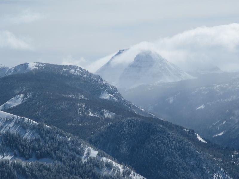
Craig captured this photo of Reids Peak on Wednesday and conditions feel quite wintry which is a big change after the extended dry weather.
Looking for real-time temps, snow, or wind?
Click HERE and then on the "western Uinta" tab for western Uinta specific, weather station network.
Recent Avalanches
A regular observer and ski guide near Wolf Creek Pass spotted one slab of wind drifted snow that had released about 100 ft wide. While skinning, he experienced collapsing and got a small drift to crack about 15 inches deep (photo below - W. Shirey).
No other significant avalanche activity to report.

Your input is vital and we're interested in what you're seeing. Please contribute to this great community resource and go here to fill out an observation.
Ad
Avalanche Problem #1
Wind Drifted Snow
Type
Location
Likelihood
Size
Description
New snow falling week has been very low density which means it has been easily drifted by winds. Winds blew from the southwest this morning and yesterday afternoon, they blew from the east mid week, and other times they have blown from the west. Regardless of direction, the strongest winds have mostly occurred at higher elevations above treeline.
These soft slabs of wind drifted snow may still be triggered today about 1.5 ft deep and 100 ft wide. Avoiding avalanches today means just searching for soft snow untouched by the wind. Areas with wind drifted snow will look rounded, pillowy, and smooth and exist under cornices, under ridgelines, or along other terrain features. The one complication is that new snow overnight and today may camouflage these wind drifts.
One more complication is that these wind slabs are resting on a wide variety of old snow surfaces which will determine how long they will remain unstable. In many places they are sitting on a old, hard, textured snow surface and may be well bonded by this weekend. In other places, these wind slabs may be resting on weak faceted snow formed during the long period of dry weather and will remain unstable for some time. It can be hard to know the difference, and the best strategy is to avoid wind drifted snow and ride slopes untouched by winds.
HEADS UP - It's easy to be complacent because conditions aren't too dangerous, and avalanches may not be too big. HOWEVER, an avalanche fatality earlier this month in Montana near West Yellowstone is an example of how a relatively small avalanche can be deadly. That avalanche was 4-11 inches deep and 75 feet wide. Read more HERE.
Additional Information
Your observations are important, so please let me know what you're seeing... click HERE and contribute to this amazing community based program
General Announcements
The information in this forecast expires 24 hours after the day and time posted, but will be updated by 07:00 Saturday, February 26th.
Before it gets too crazy, now is the time to book an avalanche awareness presentation for your group, club, or posse. You can reach me directly at 801-231-2170 or [email protected]
This forecast is from the U.S.D.A. Forest Service, which is solely responsible for its content. This forecast describes general avalanche conditions and local variations always occur.