Forecast for the Uintas Area Mountains

Craig Gordon
Issued by Craig Gordon for
Thursday, February 23, 2023
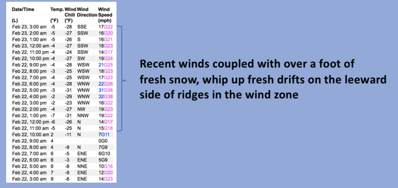
With more snow and wind on the way, look for the avy danger to bump up a notch by late in the day-
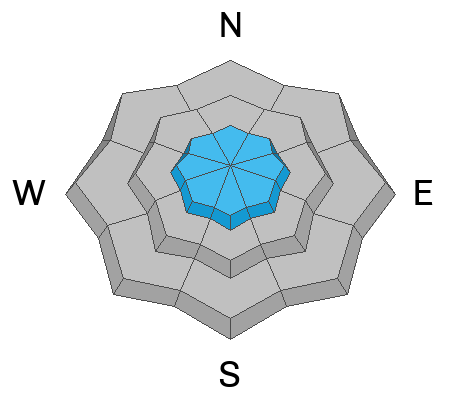
For this morning, in the wind zone at and above treeline, pockets of MODERATE avalanche danger are found on steep, wind drifted slopes. With a little provocation, both old and newer wind drifts react to our additional weight and human triggered avalanches are POSSIBLE, especially in terrain facing the north half of the compass, particularly on slopes with an easterly component to their aspect. Lose the wind and you lose the problem... LOW avalanche danger exists on mid and lower elevation terrain, especially slopes facing the south half of the compass.

Low
Moderate
Considerable
High
Extreme
Learn how to read the forecast here
Weather and Snow
Nowcast- As I attempt to balance my checkbook each month it's shockingly apparent... math isn't my strong suit. But when it comes to snow, it's less murky for me and yesterday's storm totals are an easy read... 15" of snow with barely an inch of SWE (snow water equivalent) stacked up across the range. That means the snow is chin tickling light, it's in your face, and the rent check didn't bounce this month :) As our big storm heads east, clouds are moth eaten and cold air has settled into the region with temperatures registering in negative territory as they clock in for the day shift. Throw in southerly winds blowing in the teens along the high ridges and you've got windchill delivering deisel gelling temperatures to -28 degrees. The riding and turning conditions make you forget about the cold with recent Yelp reviews rating the conditions with 4 stars.
Forecast- The next storm patiently waits its turn and a break in the action is slated through about early afternoon. Look for partly cloudy skies kicking off the day with temperatures climbing out of the deep freeze and into the teens and low 20's. Southerly winds start out reasonable, but begin ramping into the 30's and 40's for late in the day. Scattered snow showers are expected by closing bell.
Futurecast- A nice little refresh slides through the eastern front tonight and tomorrow and I bet we'll see an additional foot of snow by midday Friday. A break for Saturday with another storm in the queue to round out the weekend.
Huge thanks for all the great obs streaming in from the eastern front. Even more detailed trip reports and recent obs are found HERE.
Recent Avalanches
A few shallow wind drifts were the only game in town yesterday.
No significant avalanche activity to report, but if ya wanna geek out, click HERE to track this years slide activity throughout the range.
Ad
Avalanche Problem #1
Wind Drifted Snow
Type
Location
Likelihood
Size
Description
Above is a 24 hour data dump from Windy Peak (10,662') showing trends in wind speed, direction, and duration.
Yesterday's field observations reveal surprisingly well-behaved fresh drifts and I think the east and northeast winds might have patted the surface snow, making it less reactive to our additional weight. However, the Uinta's are a big place and I bet if you were looking for a wind slab to trigger... you can find one. With a new round of winds ramping up throughout the day, be aware of changing conditions and pump the brakes on objectives if you're seeing shooting cracks out in front your your skis, board, or sled. This is an easy avalanche dragon to avoid... lose the wind and you lose the problem.

Additional Information
Weather stations-
And... rime events have severely crippled the Uinta weather station network. I'm working to get it back up and running, but a few stations are found HERE (click weather stations, and then on the Western Uinta tab)
Observations-
Your observations are important, so please let me know what you're seeing... click HERE and contribute to this amazing community-based program
General Announcements
Issued at 03:19 on Tuesday February 23rd, this forecast expires 24 hours after the date and time posted, but will be updated by 07:00 Friday February 24th 2023.
Before it gets too crazy, now is the time to book an avalanche awareness presentation for your group, club, or posse. You can reach Craig directly at 801-231-2170 or [email protected].

This forecast is from the U.S.D.A. Forest Service, which is solely responsible for its content. This forecast describes general avalanche conditions and local variations always occur.