Forecast for the Uintas Area Mountains

Craig Gordon
Issued by Craig Gordon for
Wednesday, February 16, 2022
In general, LOW avalanche danger is found across the board and Green Light conditions blanket the danger rose, suggesting human triggered avalanches are unlikely on all aspects and elevations. While most terrain is good to go, be alert to changing weather conditions as the day wares on, especially if you're stepping into a big, committing line where triggering even a small slide could have major consequences which instantly throw a curve ball your way.
Low
Moderate
Considerable
High
Extreme
Learn how to read the forecast here
Weather and Snow
NOWCAST-
Last night's Snow Moon lived up to its reputation, helping to usher in a mini-storm which stacked up an inch of low density snow across the range. No game changer just yet, but after nearly a month with no measurable snow, we'll take every flake we can get! Cold air filtering into the region right around midnight swung anemometers around to the west and winds clock in at 20-30 mph along the high peaks, whilst temperatures hover in the teens and low 20's. A little snow might not dramatically improve riding conditions, but it will go a long way to lift spirits. And yes... I think I caught you smiling just thinking of the notion of fresh snow :)
FORECAST-
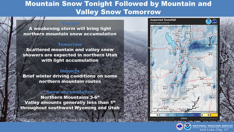
Another upstream wiggle is in the queue and it passes through the region later this morning. Under mostly cloudy skies we'll see another inch, maybe two, stack up before skies clear around dinner time. Temperatures and wind don't vary much from where we're at this morning and overnight lows crash into the single digits.
FUTURECAST-
High pressure returns to round out the work week and we'll see sunny skies with warm temperatures through Saturday. A potential pattern change evolves for early next week and computer models suggest a stronger storm on tap for late Sunday and Monday. Too early to tell, but we'll track the facts and get back to you with the latest updates.

Chad took his Brackpack for a super, pre-Super Bowl tour near Soapstone and found a variety of snow surface conditions. In between old tracks, wind funk, and varying degrees of supportable suncrusts, Chad's posse found a few patches of soft snow on mid elevation, sheltered slopes. His very informative and most excellent trip report is found HERE.
Trip reports and current state of the snowpack observations are found HERE.

Looking for real-time temps, snow, or wind?
Click HERE and then on the "western Uinta" tab for western Uinta specific, weather station network.
Recent Avalanches
No significant avalanche activity to report

Your input is vital and we're interested in what you're seeing. Please contribute to this great community resource and go here to fill out an observation.
Ad
Avalanche Problem #1
Normal Caution
Type
Location
Likelihood
Size
Description
As the day progresses and an additional inch or two of snow stacks up, ridgetop winds could finally have a little fresh snow to work with and may form a shallow drift or two in the wind zone, above treeline. No glaring red flag here, but something to be aware of especially if our travels bring us to steep, committing terrain where there's little room for error. By late in the day I'd look for and avoid fat, rounded pillows of snow that may be large enough to knock me off my feet. In addition, remember that big, open terrain above treeline offers very hard, wind pressed snow and most south facing slopes have a stout ice crust on them. The main hazard on these slopes for skis, boards, or a sled is an uncontrollable slide for life... and that means- sliding downhill and not being able to stop.
On Saturday, Ted and I found great riding conditions on very weak surface snow in wind sheltered, shady terrain. I describe the setup in the viddy above.
Additional Information
Your observations are important, so please let me know what you're seeing... click HERE and contribute to this amazing community based program
General Announcements
The information in this forecast expires 24 hours after the day and time posted, but will be updated by 07:00 Thursday, February 17th.
Before it gets too crazy, now is the time to book an avalanche awareness presentation for your group, club, or posse. You can reach me directly at 801-231-2170 or [email protected]
This forecast is from the U.S.D.A. Forest Service, which is solely responsible for its content. This forecast describes general avalanche conditions and local variations always occur.