NOWCAST-
Wow... yesterday's storm looked underwhelming on paper. But our mountains threw in a little special sauce, created a bit of meteorological magic, and voila... we squeezed out 5"-9" of low density snow across the range with the North Slope stacking up the higher totals. What a nice little under-forecast-over-deliver kinda storm... I'm wishing my stock portfolio presented a similar profile! Skies cleared early this morning and temperatures cratered into the single digits. Northeast winds blow in the teens along the high peaks. Riding and turning conditions drastically improved overnight and low angle slopes are the ticket in order to avoid bottom feeding on hard, old snow surfaces.
FORECAST-
Look for sunny skies with high temperatures climbing into the low 20's. Winds shift to the west-northwest and they may become a nuisance, especially later in the day along the high ridges. Overnight lows dip into the teens.
FUTURECAST-
High pressure returns for a weekend visit and we'll see clear skies with very mild temperatures Saturday. A warm, windy Sunday is on tap, prior to a good looking storm slated to slide into the region Monday, delivering colder air along with nearly a foot of snow.
Trip reports and current state of the snowpack observations are found
HERE.
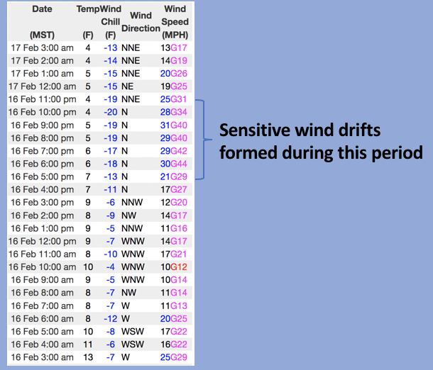
Looking for real-time temps, snow, or wind?
Click HERE and then on the "western Uinta" tab for western Uinta specific, weather station network.
No significant avalanche activity to report