Forecast for the Uintas Area Mountains

Craig Gordon
Issued by Craig Gordon on
Thursday morning, February 15, 2024
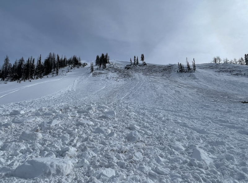
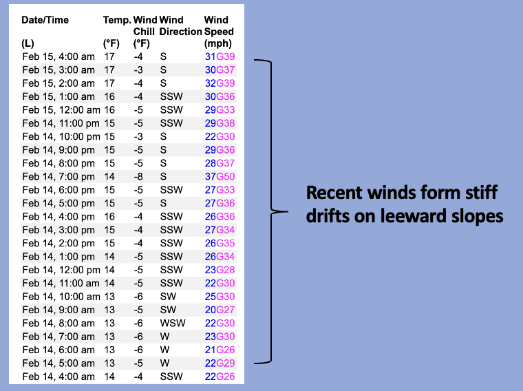
Like an early 70's muscle car, a rowdy storm burns rubber across the desert, screeching around the bend on two wheels, and comes in hot... delivering elevated avy conditions to the danger rose-
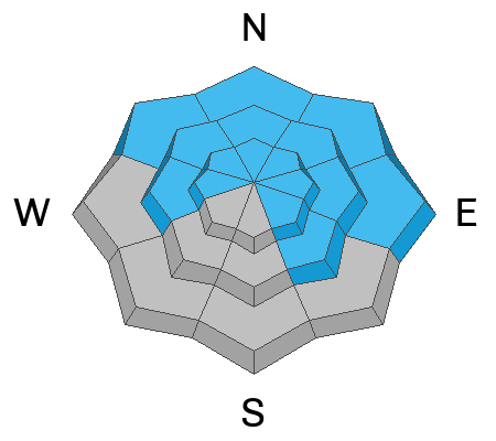
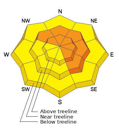
Near and above treeline, particularly in the wind zone, you'll find CONSIDERABLE avalanche danger. Human triggered avalanches are LIKELY especially in terrain facing the north half of the compass. Disclaimer... don't remove this tag and don't get lulled into thinking storm snow and fresh drifts are the only avalanche game in town. Steep, rocky slopes with a shallow, weak snowpack have the potential to produce a slide that breaks deeper and wider than you might expect. Any slide that fails on weak layers buried deep in our snowpack will instantly ruin your day.

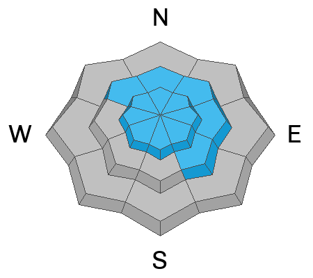
Wind and storm snow light up lower elevation terrain where you'll find MODERATE avalanche danger. Human triggered avalanches are POSSIBLE on steep wind drifted slopes around the dial.
Low
Moderate
Considerable
High
Extreme
Learn how to read the forecast here
Special Announcements
We are seeking a passionate individual to join us as Executive Director of the nonprofit Utah Avalanche Center. Click here for more information.
Weather and Snow
Nowcast- Hang onto your hats.... if you wear that kinda thing, 'cause a fast moving storm is steam-rolling its way across the west desert and heavy snow should slam into our mountains in the next few hours. Until then, thick clouds stream into the area and light snow is just starting to fall. Winds from the south and southwest blow in the 30's and 40's near the peaks. Current temperatures hover in the upper 20's at the trailheads and in the low to mid 20's along the ridges. The powder party just got crashed and I think the winds are having their way with upper elevation terrain. But don't let your hearts be troubled... let some storm snow stack up and then consider lower elevation, wind sheltered slopes where you'll find soft, creamy snow.
Forecast- A robust blast of snow slides into the area before sunrise and we should see a couple inch-an-hour, storm snow stacking up in a hurry. I'm thinking a foot of snow by dinner time. Winds crank from the southwest and they're gonna be a nuisance, blowing in the 40's near the high ridges. Later today, winds switch to west and northwest and decrease in velocity as colder air filters into the region. High temperatures don't vary much from where we're at this morning and overnight low dip into the teens.
Futurecast- Expect lingering snow showers for Friday, a spectacular day is on tap Saturday, with another storm teeing off for Sunday.
Our good friends and longtime partners at the City of Salt's National Weather Service, have issued a Winter Weather Advisory for the Uinta zone.
Snow coverage is excellent with soft, dry powder on the polars, whilst a zipper, heat crust is found on the solars.
Total snow depths/total water at Uinta SNOTEL sites:
Chalk Creek #1 (9,171') - 57"/13.8"
Hayden Fork (9,130') - 46"/11.4"
Trial Lake (9,992) - 67"/15.5"
Wolf Creek Peak (9,796) - 61"/14"
Currant Creek (7,915') - 40"/9.6"
Strawberry Divide (8,123') - 52"/14.4"
Recent Avalanches
On Monday, Joey and I investigated a large, snowmobile triggered slide in Upper Chalk Creek. Breaking 6'-10' deep and 600' wide resulting in a VERY CLOSE CALL on Sunday, February 11th. All the deets are found HERE.

For more Uinta observations and recent avalanche activity click HERE.
Ad
Avalanche Problem #1
Persistent Weak Layer
Type
Location
Likelihood
Size
Description
Steep, rocky, heavily wind loaded slopes like in the image above from last weeks close call in Chalk Creek, remain the prime suspect terrain to continue avoiding.
The burning snowpack stability question that keeps racing through my mind is... can I trigger an avalanche that breaks into weak layers of snow, and if so... where?
Rather than stay awake all night trying to figure out which exact slope is sketchy and gonna roll me, I break it down in my mind, catalog different avalanche characteristics in my cerebral Rolodex, and attempt to avoid a paper cut to my frontal lobe. I'm looking at the big picture... a common 30,000 foot view. And all the recent avalanches I've been crawling around and investigating have been triggered in upper elevation, steep, rocky terrain with a shallow, weak snowpack on slopes facing the north half of the compass. The complex notion is... these slopes are thin because they've either avalanched multiple times this year, like Sunday's close call in Chalk Creek, or they've been stripped by one wind event and then reloaded by another wind event from a different direction... or both! Now of course, my mind is spinning!
Knowing I'm not going to outsmart this avalanche dragon, we instead agree to disagree. I'll avoid steep, rocky, mid and upper elevation terrain facing the north half of the compass, where the odds of triggering a slide lessen over time, but the consequences remain severe. I'll stick with lower angle shady slopes, or if I wanna get in bigger terrain, I simply switch aspect and head to the sunnies.
With all the great riding to be had, there's no reason the pull on the dogs tail, cause its bite is worse than its bark!
Avalanche Problem #2
Wind Drifted Snow
Type
Location
Likelihood
Size
Description
A 24 data dump from Windy Peak (10,662') shows Wednesday's increase in south and southwesterly winds, continuing into this morning.
There's no shortage of snow to blow around and a bump in the winds for the past 24 hours, whips up additional rounds of fresh drifts and deposits snow lower down-slope than we might expect. Found mostly in mid and upper elevation, leeward terrain facing the north half of the compass, look for a few rogue drifts on south facing slopes and cross-loaded in terrain features like chutes and gullies. In any case, this is a manageable avalanche dragon as fresh drifts are easy to detect by their fat, rounded appearance. Lose the wind and you lose the problem.
Avalanche Problem #3
New Snow
Type
Location
Likelihood
Size
Description
Storm snow piles up fast and furious in the next couple hours and fresh snow will be reactive to our additional weight on sustained steep slopes. This is an easy avalanche problem to avoid by toning our slope angles down a few degrees.
Additional Information
The Uinta weather station network was upgraded this summer and all that real-time info is found HERE. Simply click on "western Uinta" tab and then "weather stations" tab.

We are always looking for snow and avalanche observations or just general riding conditions. So... if you see something, say something. You can reach me directly at [email protected] or 801-231-2170.
Also, if you're looking for more avy education opportunities for yourself, your crew, or your club please don't hesitate to reach out to me and we'll find a presentation, class, or clinic for ya!
General Announcements

Issued at 0400 on Thursday, February 15th this forecast will be updated by 0700 Friday, February 16th, 2024.
This forecast is from the U.S.D.A. Forest Service, which is solely responsible for its content. This forecast describes general avalanche conditions and local variations always occur.