Forecast for the Uintas Area Mountains

Craig Gordon
Issued by Craig Gordon on
Wednesday morning, February 14, 2024
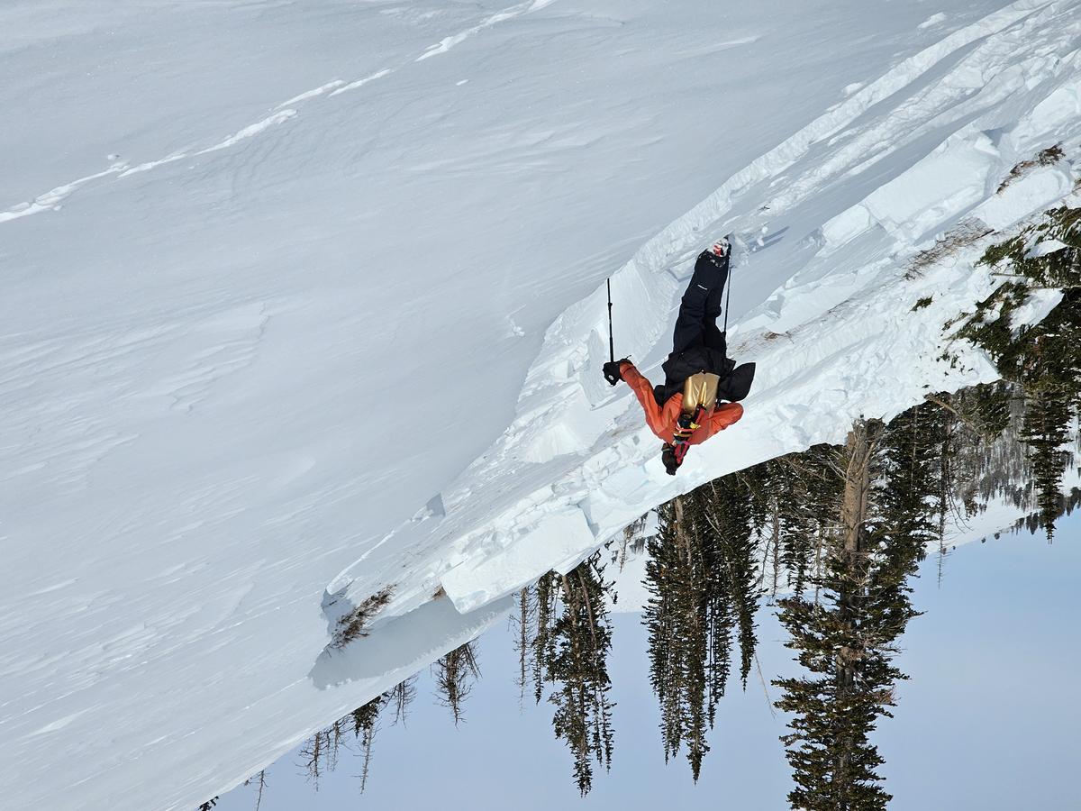
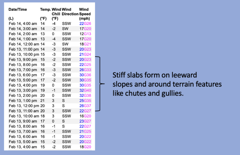
The avy danger drops a notch but the consequences of triggering a slide still delivers a knockout punch-
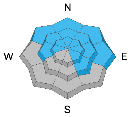
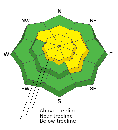
Near and above treeline you'll find MODERATE avalanche danger. Human triggered avalanches are POSSIBLE especially in terrain facing the north half of the compass. Disclaimer... don't remove this tag and don't get lulled into thinking fresh drifts are the only avalanche game in town. Steep, rocky slopes with a shallow, weak snowpack have the potential to produce a slide that breaks deeper and wider than you might expect. Any slide that fails on weak layers buried deep in our snowpack will instantly ruin your day.

Mid and lower elevation terrain, especially slopes facing the south half of the compass offer LOW avalanche danger.
Note to self-
Hmm... avy danger sounds kinda sly, kinda cagey, kinda wily (coyote :). And it feels like there's no reason to roll the dice and take my chances when there's amazing pow on low angle, wind sheltered, mid and low elevation terrain. Done, done, and done.
Low
Moderate
Considerable
High
Extreme
Learn how to read the forecast here
Weather and Snow
Nowcast- A little storm slid into the region overnight and our mountains benefit from the fruit of orographic lift, squeezing a couple inches of juice out of low laying clouds. Near the high peaks, winds blow in the teens and mid 20's from the south and southwest. Temperatures register in the teens and low 20's. Riding and turning conditions remain all-time, especially on wind sheltered slopes.
Forecast- Look for mostly cloudy skies with on again, off again snow showers this morning. In general, snow totals look meager, just a couple more inches materializing by late morning with a clearing trend as the day wares on. Winds blowing from the southwest remain reasonable and in the mid to upper 20's. Temperatures climb into the upper 20's and overnight lows dip into the teens.
Futurecast- No ginormous storms in the hopper, but the pattern remains active with unsettled weather throughout the week.
Sure you can follow us on Insta, FB, and X (formerly known as Twitter). More importantly, follow the rainbow, which leads to the UAC stoke-mobile eastbound on I-80, which of course leads to sunny skies, fresh pow, and maybe even a unicorn inside that trailer :)
Snow coverage is excellent with soft, dry powder on the polars, whilst a zipper, heat crust is found on the solars.
Total snow depths/total water at Uinta SNOTEL sites:
Chalk Creek #1 (9,171') - 57"/13.8"
Hayden Fork (9,130') - 46"/11.4"
Trial Lake (9,992) - 70"/15.3
Wolf Creek Peak (9,796) - 64"/13.9
Currant Creek (7,915') - 41"/9.5"
Strawberry Divide (8,123') - 52"/14.4"
Recent Avalanches
On Monday, Joey and I investigated a large, snowmobile triggered slide in Upper Chalk Creek. Breaking 6'-10' deep and 600' wide resulting in a VERY CLOSE CALL on Sunday, February 11th,

For more Uinta observations and recent avalanche activity click HERE.
Ad
Avalanche Problem #1
Persistent Weak Layer
Type
Location
Likelihood
Size
Description
We suspect this meaty, tree snapping avalanche was triggered mid slope, pulling the rug out from underneath, allowing the entire roof to crash down on the riders below.
The burning snowpack stability question that keeps racing through my mind is... can I trigger an avalanche that breaks into weak layers of snow, and if so... where?
There's so many variables right now, and let's face it, our snowpack structure behaves like it's in its teenage years... yeah, it's quite complex. Not the kind of complexity like we see on lean snow years with weak, rotten, trap door kinda snow. Instead, complexity that revolves around a snowpack that in some places is strong, thick, and stable, and a few hundred yards away is unusually thin and weak for mid February.
Rather than stay awake all night trying to figure out which exact slope is sketchy and gonna roll me, I break it down in my mind, catalog different avalanche characteristics in my cerebral Rolodex, and attempt to avoid a paper cut to my frontal lobe. I'm looking at the big picture... a common 30,000 foot view. And all the recent avalanches I've been crawling around and investigating have been triggered in upper elevation, steep, rocky terrain with a shallow, weak snowpack on slopes facing the north half of the compass. The complex notion is... these slopes are thin because they've either avalanched multiple times this year, like Sunday's close call in Chalk Creek, or they've been stripped by one wind event and then reloaded by another wind event from a different direction... or both! Now of course, my mind is spinning!
Knowing I'm not going to outsmart this avalanche dragon, we instead agree to disagree. I'll avoid steep, rocky, mid and upper elevation terrain facing the north half of the compass, where the odds of triggering a slide lessen over time, but the consequences remain severe. I'll stick with lower angle shady slopes, or if I wanna get in bigger terrain, I simply switch aspect and head to the sunnies.
With all the great riding to be had, there's no reason the pull on the dogs tail, cause its bite is worse than its bark!
Avalanche Problem #2
Wind Drifted Snow
Type
Location
Likelihood
Size
Description
A 24 data dump from Windy Peak (10,662') shows Tuesday's increase in southwesterly winds.
There's no shortage of low density to blow around and a bump in the winds late Tuesday, whips up a round of shallow, fresh drifts found mostly in upper elevation, leeward terrain facing the north half of the compass. As winds swirl near the peaks, expect shallow drifts on upper elevation south facing terrain as well. In either case, this is a manageable avalanche dragon in size and scope as fresh drifts are easy to detect by their fat, rounded appearance. Lose the wind and you lose the problem.
Additional Information
The Uinta weather station network was upgraded this summer and all that real-time info is found HERE. Simply click on "western Uinta" tab and then "weather stations" tab.

We are always looking for snow and avalanche observations or just general riding conditions. So... if you see something, say something. You can reach me directly at [email protected] or 801-231-2170.
Also, if you're looking for more avy education opportunities for yourself, your crew, or your club please don't hesitate to reach out to me and we'll find a presentation, class, or clinic for ya!
General Announcements

Issued at 0400 on Wednesday, February 14th this forecast will be updated by 0700 Thursday, February 15th, 2024.
This forecast is from the U.S.D.A. Forest Service, which is solely responsible for its content. This forecast describes general avalanche conditions and local variations always occur.