March Kicks Off Our Spring Campaign- Donate Now to Support Forecasting

Forecast for the Uintas Area Mountains

Craig Gordon
Issued by Craig Gordon on
Monday morning, February 15, 2021
HEADS UP... IT'S THE REAL DEAL... AVALANCHE CONDITIONS ARE DANGEROUS
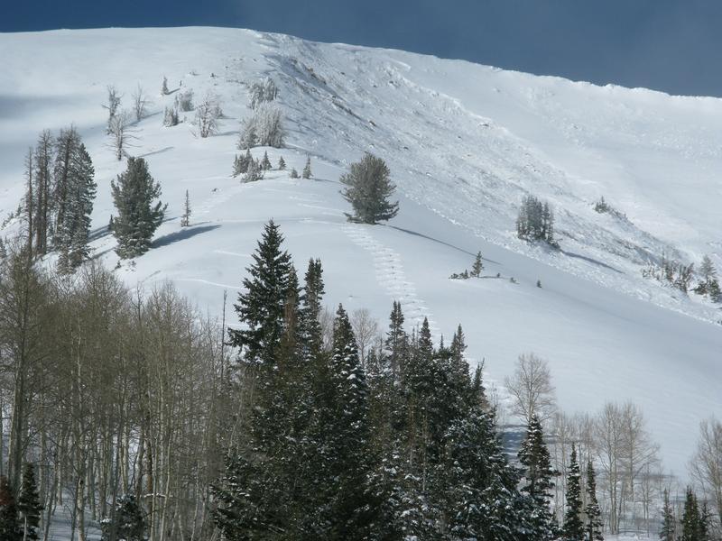
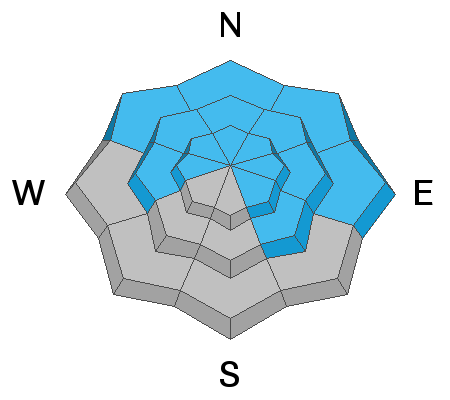
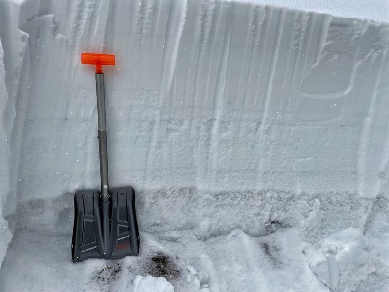
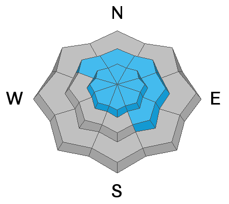
More snow and wind will continue overloading our fragile snowpack and HUMAN TRIGGERED AVALANCHES ARE VERY LIKELY and NATURAL AVALANCHES LIKELY. In the wind zone, above and near treeline, the avalanche danger is HIGH especially on slopes facing the north half of the compass, and particularly those with an easterly component to their aspect. Once triggered, today's avalanches have the potential to quickly get out of hand, breaking deep and wide, resulting in a dangerous slide.

CONSIDERABLE avalanche danger is found on mid elevation terrain where steep slopes are reaching their tipping point and HUMAN TRIGGERED AVALANCHES ARE LIKELY.
At lower elevations below treeline and all south and southwest facing slopes, the danger is MODERATE.

Riding conditions continue improving and there's lots of great powder. Fortunately there's also plenty of terrain in the Uintas less than 30 degrees in steepness where avalanches won't happen. Make sure to also avoid being under steep slopes in avalanche runout zones.
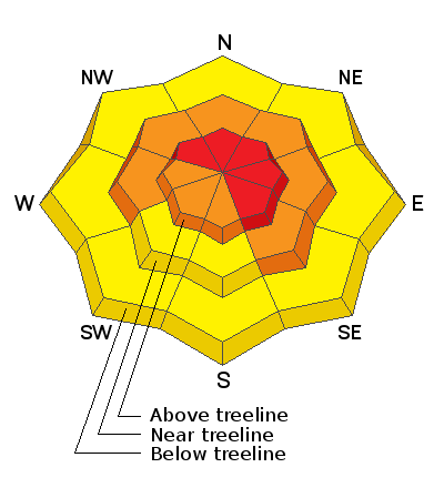
Low
Moderate
Considerable
High
Extreme
Learn how to read the forecast here
Avalanche Warning
THE AVALANCHE DANGER FOR THE WARNING AREA IS HIGH
IN EFFECT FROM 6 AM MST THIS MORNING TO 6 PM MST TUESDAY
FOR THE MOUNTAINS OF MUCH OF THE STATE OF UTAH, INCLUDING THE WASATCH RANGE...BEAR RIVER RANGE...UINTA MOUNTAINS...MANTI-SKYLINE PLATEAU...THE FISH LAKE REGION…PAHVANTS…TUSHARS…AND THE CEDAR CITY AREA MOUNTAINS.
DANGEROUS AVALANCHE CONDITIONS EXIST. NATURAL AND HUMAN TRIGGERED AVALANCHES ARE LIKELY OVER THE NEXT SEVERAL DAYS. STAY OFF OF AND OUT FROM UNDER SLOPES STEEPER THAN 30 DEGREES.
Special Announcements
The final report about the avalanche which killed four people last Saturday in upper Mill Creek Canyon in the central Wasatch Mountains is available HERE. Our deepest condolences go out to the friends and families involved.
Weather and Snow
Nowcast-
A short-lived break in the action came and went whilst we slept and light snow is just starting to fall. It'll feel like winter when you roll out the door as temperatures register in teens with single digits along the ridges. West and northwest winds clock in at 10-20 mph along the high peaks. The recent round of storms stacked up a solid foot of snow and as such, riding and turning conditions vastly improved the past few days.
Forecast-
Expect mostly cloudy skies with snowfall intensifying and westerly winds ramping up around midmorning. Heavy at times snowfall kicks this afternoon, with increasingly strong westerly ridgetop winds blowing in the 50's and 60's. High temperatures reach into the mid 20's with overnight lows dipping into the teens. A foot of new snow by tomorrow morning is a good bet.
Futurecast-
The graphic above tells the tale of a winter that decided to show up to the party. Snow continues through early Wednesday.
Looking for real-time temps, snow, or wind?
Click here and then on the "western Uinta" tab for western Uinta specific, weather station network.
Recent Avalanches
Yesterday, I crawled around this large natural slide in Upper Weber Canyon, which I suspect was triggered by a cornice slamming down on the slope. Breaking wide and to the dirt, it appears this very connected slab released early Sunday morning.
In the past rtwo weeks, many large avalanches were triggered across the range including a near miss at Moffit Peak with an amazing viddy HERE.
Recent avalanche activity is found HERE.

More obs and trip reports found here.
Ad
Avalanche Problem #1
Persistent Weak Layer
Type
Location
Likelihood
Size
Description
It's no mystery our snowpack is a mess. As a matter of fact, many slopes throughout the range are unsupportable as they harbor layers of weak, sugary, faceted snow found near the bottom of the snowpack (see photo below). On its own accord that's not a big deal, but when we add a cohesive slab on top (strong snow resting on weak snow), now we've got the ingredients coming together for dangerous avalanche conditions. In the wind zone, the slab is very hard and connected across large areas. On slopes sheltered from the wind, the slab is softer but still cohesive enough to produce a slide. In either case, this combo is found mostly on mid and upper elevation terrain facing the north half of the compass and many slopes just wait for a trigger like us to roll along and knock the legs out from underneath. Here's what makes matters complicated... you can trigger avalanches by simply riding under a steep slope, so part of today's avalanche strategy must include staying off and out from under steep terrain.
The viddy below demonstrates how there's no structure or base to our snowpack.
The photo below clearly shows the weak faceted snow near the ground. There is also a weak layer of facets in the middle of the snowpack on which avalanches can also fracture.
Avalanche Problem #2
Wind Drifted Snow
Type
Location
Likelihood
Size
Description
Recent winds (see video below) had no problem whipping up stiff wind drifts which will react to our additional weight, but they're camouflaged under this weekends storm snow and they're hard to detect. But here's what I know... you'll find them on the leeward side of ridges and around terrain features like chutes and gullies. Today you'll want to look for and avoid any fat, rounded, piece of snow, especially if it sounds hollow like a drum. And remember- triggering even a small wind drift offers the potential to quickly get out of hand if that piece of snow breaks into deeper buried weak layers as it crashes onto the slope below.
The video below illustrates Fridays winds at the top of Double Hill.
Additional Information
Last week, Andy, Joey, and I set up the avalanche beacon training park at the Nobletts trailhead. There is also one at the Bear River Trailhead that Ted Scroggin set up. These beacon parks have pre-buried beacons that you can turn on/off with a control panel. It only takes a few minutes to refresh your beacon searching skills at one of these places.
I will update this forecast by 7:00 AM tomorrow, Tuesday, February 16th.
Your observations are important, so please let me know what you're seeing... click HERE and contribute to this amazing community based program
General Announcements
If you see or trigger an avalanche or just wanna let me know what you're seeing you can reach me directly at 801-231-2170 or [email protected]
This forecast is from the U.S.D.A. Forest Service, which is solely responsible for its content. This forecast describes general avalanche conditions and local variations always occur.