Nowcast - The first wave of storminess ushered in a south-side shuffle overnight, sliding through Wolf Creek, Currant Creek, Daniel's and Strawberry delivering 3" of snow with .30" H2O. So sorry North Slope and Mirror Lake Corridor, your party invite request didn't get processed until early this morning and you're `on the lean side of the storm with 1/2 that amount. In either case, a thin coat of white paint is a welcome sight and there's more headed our way. In the meantime, skies are mostly cloudy, while winds blowing from the southwest crank 30-50 mph along the ridges, gusting to 70 mph near the high peaks. Temperatures are just beginning to cool into the mid and upper 20's °F.
Forecast - A nice slug of moisture slides through the Uinta zone in the next couple hours and should deliver 3"-6" of dense, heavy snow before an early afternoon break in the action. Temperatures are gonna be balmy with highs rising into the mid 30's °F. Winds blowing 20-40 mph from the southwest are gonna be obnoxious near the ridges.
Futurecast - Look for another good shot of snow overnight with continued strong winds and mild temperatures. I'm still thinking we stack up 10"-12" of snow with an inch of SWE before snow tapers off Thursday morning. Expect a lull in the action to wrap up the workweek and slide into the weekend followed by an active pattern for early next week... looks promising and we'll keep ya posted.
Travel Conditions - Access has taken a hard hit over the past few days from warm temperatures and increasingly strong sunshine. Snow depths vary quite a bit, but get above 9,000' and swing over to the north half of the compass and you'll find a mostly right-side up snowpack averaging 1-4' deep. In general, protected polars are riding in the glass half full category, while above treeline the snow surface has been worked by the elements and yeah... we are long overdue for a thick coat of white paint.
Ace observers and dynamic duo, but more important... as genuine as the day is long, Trevor and Fran stomped around Wolf Creek yesterday and found a happy snow surface hiding a cranky snow structure. More on their travels HERE.
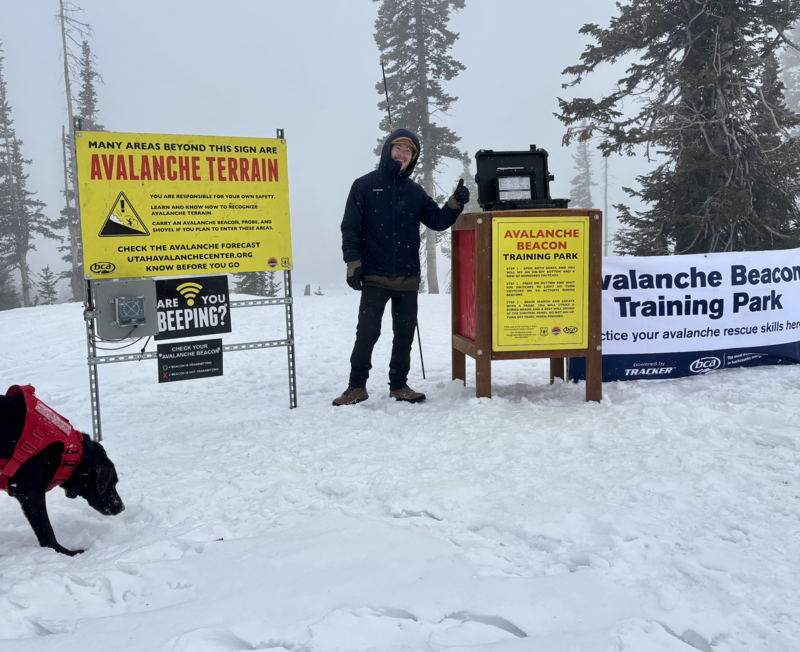
On Monday... Andy, Liam, and Juniper (the dog) installed a beacon training park near Wolf Creek Summit. It's super straight-forward and intuitive, and all the instructions are at the control center. Next time you see Liam or Andy, hit 'em up with a high-five for all the hard work. Truth be known... Juniper was only onboard because she thought the crew kept saying "bacon training park." So in lieu of a high-five, a back scratch or an Andy approved meat treat acknowledging Juniper's moral support will probably suffice :)
No new activity was reported from the backcountry yesterday.