Forecast for the Uintas Area Mountains

Craig Gordon
Issued by Craig Gordon on
Tuesday morning, February 11, 2025
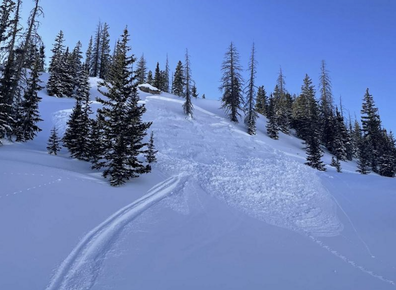
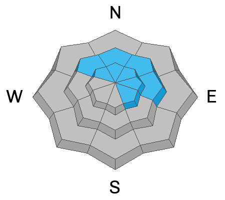
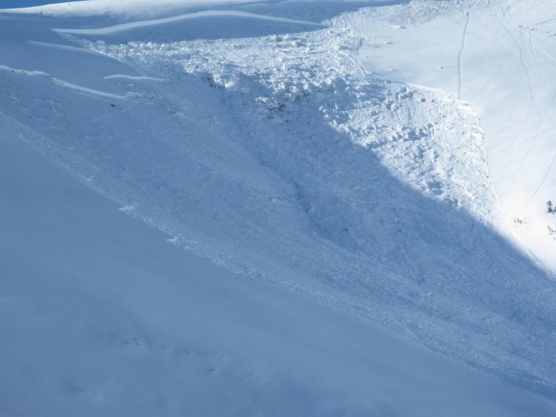
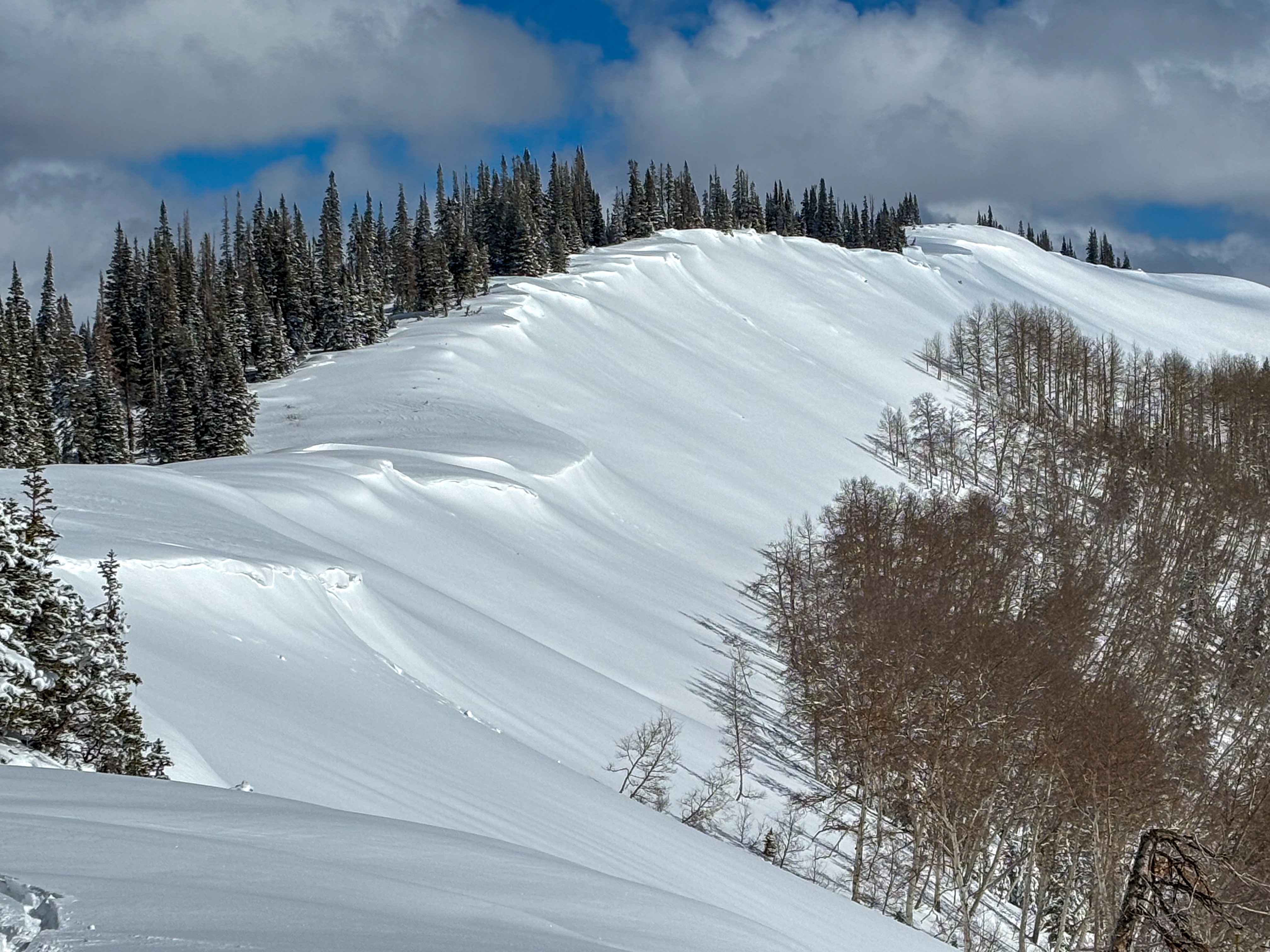
Upper elevation slopes facing the north half of the compass offer CONSIDERABLE avalanche danger and human-triggered avalanches are LIKELY. Here's the wind up and the pitch... once triggered, today's avalanches can fail on faceted snow now buried several feet deep, resulting in a slide breaking deeper and wider than you might expect, throwing a complete curve ball at my day. Slopes that are thin and rocky or have avalanched several times this season remain suspect.
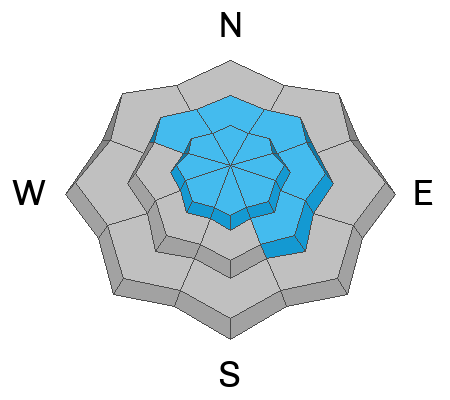
Mid and low elevations offer mostly MODERATE danger where human-triggered avalanches within the weekend storm snow are POSSIBLE.
I'm not pulling on the avalanche dragon tails today. Instead, I'm flipping aspects to the south (solar) where fresh snow rests on a supportable base, or tagging a soft, creamy reward on low elevation, north facing, (polar) slopes.
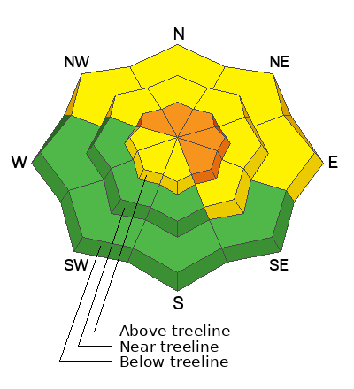
Low
Moderate
Considerable
High
Extreme
Learn how to read the forecast here
Special Announcements
Wondering who hijacked our winter, where weak layers in the snowpack are trending, or perhaps you're just PWL curious? Well then, please join UAC Forecaster Craig Gordon (that's me :) at Ecker Hill Middle School, Tuesday February 11th from 6:30-8:00 PM for a State of the Snowpack presentation hosted by Park City Professional Ski Patrol Association -- Reserve a spot, here!
Weather and Snow
Nowcast- With high thin clouds overhead, a nearly full, Wolf Moon, cast a cold, intriguing light on our mountains as temperatures register in the single digits. After a slight bump to nearly 30 mph near the high peaks at the turn of the new day, Southwest winds mellowed into the low 20's where they sit at o'dark thirty this morning.
Forecast- A weak system ushers in cloudy skies, light snow showers, and a switch to west and northwest winds which bump into the 30's and 40's by days end. A blast of cold air keeps high temperatures hovering in the mid teens with overnight lows cratering into negative territory.
Futurecast- A break in the action is slated for Wednesday and Thursday, before a nice looking blast of snow, water, and wind are poised to buzz the Beehive State. Storm deets are still getting dialed in and we'll have a better idea on timing and strength for Wednesday's update.
On a mostly supportable, go anywhere base, with a low density, creamy topper... the western Uinta's are firing.
Recent Avalanches
Generally manageable in size, but even a small storm slab like this piece of snow triggered near Wolf Creek yesterday could potentially catch you off guard and boss you around a bit. Thanks to Cael for looping us in.
Get up to speed by checking out obs, avalanches and trip reports from across the range and beyond, here!
Ad
Avalanche Problem #1
Persistent Weak Layer
Type
Location
Likelihood
Size
Description
The usual suspects keeping popping up in the lineup... steep, rocky, shallow either by way of repeaters or shallow snow depth.
Let's face it... the snowpack is downright complicated and the snow stability pattern is a bit like playing a game of Minesweeper (thanks Cody Hughes for the analogy :) But rather than just roll the dice and take my chances I'm wrapping my brain around some common snowpack themes to draw a rational conclusion and here's what we've got-
From tip to tail on the north half of the compass, faceted snow is now buried in the mid portion of the snowpack and a couple of feet beneath the snow surface. The semi-dormant PWL came back to life with Friday's dense snow (nearly 2" of SWE) and strong winds. We know this because the biggest clue to avalanches is... avalanches, as evidenced by natural and human triggered slides breaking up to 3' deep. Here's where the rubber hits the road... this problem isn't healing overnight, so we need to exercise a bit of patience. The good news is... the coverage is pretty remarkable and there's miles and miles of terrain to ride without even having to put ourselves at risk. Avoidance is key right now and all the avy-savvy folks I know are simply avoiding terrain where the problem exists and still get in a great day of riding. Done and done!
Avalanche Problem #2
Wind Drifted Snow
Type
Location
Likelihood
Size
Description
Duchesne Ridge at 10,000' loaded up and corniced showing obvious sings of wind-drifting.
Recent winds whip up a batch of soft slabs, 6"-12" deep on mid and upper elevation leeward slopes, facing northwest through north through southeast. Look for signs of wind loading like fat, rounded pillows, cornices or scouring on windward slopes that help you gauge where the snow has been stripped and where it's been loaded. As we start to step into bigger, more consequential terrain, don't forget that even a manageable avalanche can become unmanageable quickly on the right slope.
Additional Information
The UAC Avalanche Transceiver Training Park is rocking and rolling at the Nobletts trailhead. Break out your gear, dust off your backcountry partners, and sharpen your perishable rescue skills with some practice!
General Announcements
We are always looking for snow and avalanche observations or just general riding conditions. In the meantime reach out to us with questions, concerns, or if you see anything in your travels! Contact us directly through the info below:
This forecast is from the U.S.D.A. Forest Service, which is solely responsible for its content. This forecast describes general avalanche conditions and local variations always occur. This forecast was issued on Tuesday, February 11th at 04:00AM and expires 24 hours after it was issued.