Forecast for the Uintas Area Mountains

Craig Gordon
Issued by Craig Gordon for
Monday, December 5, 2022
The snowpack is at a tenuous balance and avalanche danger remains tricky-
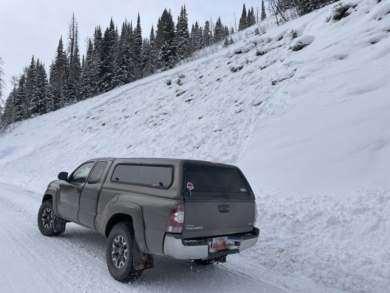
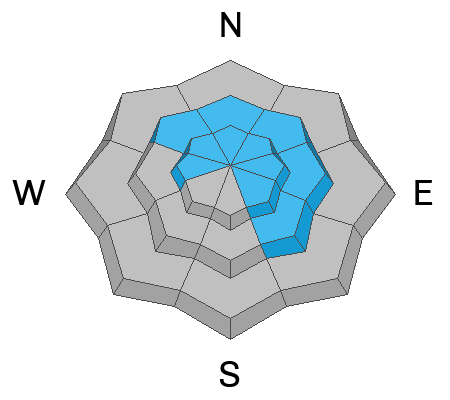
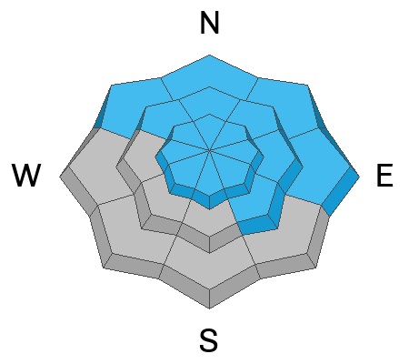
Steep, mid and upper elevation slopes, especially those facing the north half of the compass in the wind zone above treeline, offer CONSIDERABLE avalanche danger. Human triggered avalanches breaking deeper and wider than you might expect are LIKELY, particularly where stiff wind drifted snow rests atop weak sugary snow. In addition, recent winds made their way into lower elevation shady terrain where you'll find a MODERATE avalanche danger and human triggered avalanches are POSSIBLE. Even low elevation terrain got into the mix and you could get surprised on a steep slope right near the trailhead. The Mill Hollow Slide path instantly comes to mind.
LOW avalanche danger is found on low and mid elevation south facing slopes and human triggered avalanches are UNLIKELY.

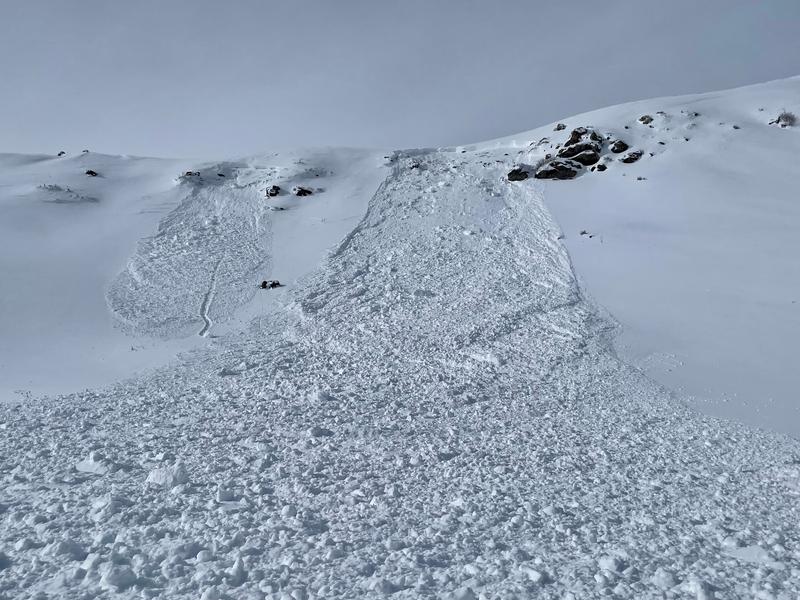
Here's your exit strategy- find a mellow, low angle south facing slope or big open meadow with no overhead hazard... (meaning, no steep slopes above or adjacent to where you're traveling) and practice your riding skills like carving deep trenches in fresh snow. Remember, don't get too throttle happy because it's still low tide and there's plenty of reef barely hidden underneath our recent storm snow. With a significant danger of hitting rocks, stumps, and other obstacles, you'll wanna tone it down today and don't let a buried treasure ruin your season.
Low
Moderate
Considerable
High
Extreme
Learn how to read the forecast here
Special Announcements
Join the Utah Avalanche Center and the Division of Outdoor Recreation to celebrate the Fourth Annual Avalanche Awareness week, from December 4 - December 11. Click HERE to view the full list of events for the week.

Mirror Lake Highway is closed for the season. SR-35 (Wolf Creek Pass) remains open.
Weather and Snow
Nowcast- A nice coat of North Slope favored white paint rolled through the region late last night, delivering 7" of snow with .50" H2O. The south half of the range lags slightly behind, but still reports a respectable 5" of snow... and more is on the way! As cold air filters into the area, temperatures are falling into the 20's and mid teens. Sunday's southwest winds blowing to 60 mph tapered off around midnight, switched to the west and currently blow in 20's along the high ridges. This mornings trailhead commute might be a gong show, but give it a minute or two, let everyone get to work and then get after it... early season riding and turning conditions are all time and worth the patience.
Forecast- Another band of moisture fills in as I type early this morning (or is it late last night :) and that should deliver another couple inches of snow. Look for a midday break with additional snow slated for late in the day. West and northwest winds remain well-behaved, blowing in the 20's with a few gusts in the mid 30's along the high peaks. High temperatures don't vary much from where we're at this morning and overnight lows dip to the single digits. Storm totals by Tuesday morning should tally in the 10" range.
Futurecast- A break in the action is slated for Tuesday, but active weather continues every other day this week with a bigger storm on tap to round out the work week.

While I was in the Mill Hollow zone Saturday, Ted's travels took him to Whitney Basin, Micheal J stomped around the Lower Weber Drainage, whilst Andy traveled south towards Tower Mountain. Trip reports and recent obs are found HERE.
Recent Avalanches
No mystery here near the Mill Hollow Trailhead on the way to snag a Christmas tree... a weak snowpack was overloaded by Friday's robust storm, producing widespread avalanche activity across the range.
Plenty of avalanche activity this week and the common theme is this... avalanches are getting triggered from a distance, breaking 2' deep and up to 200' wide, and are failing on weak faceted snow formed during the very cold, mid November dryspell. More deets found HERE.
Ad
Avalanche Problem #1
Wind Drifted Snow
Type
Location
Likelihood
Size
Description
24 hour data dump from Lofty Lake Peak (11,186') depicting the evolution of our storm.
Southwest winds cranked 30-60 mph along the high ridges yesterday and there's no shortage of snow available for transport. So, the most obvious avalanche hazard today are fresh drifts that'll react to our additional weight. Problem is... yesterday's drifts conceal older wind drifted snow that formed last week and that's all camouflaged by this mornings storm snow. So, yes... the entire deal is a bit more complicated than meets the eye. Found mostly on the leeward side of upper elevation ridges, due to the strength and duration of winds, I'd also be on the lookout for fresh drifts around terrain features like chutes and gullies. In either case, both new and older drifts now rest on weak, faceted, older snow and that means avalanches are gonna be easy to trigger.
Obvious signs of unstable snow include cracking, collapsing, and whoomping noises as well as natures freebie... natural avalanches!
Avalanche Problem #2
Persistent Weak Layer
Type
Location
Likelihood
Size
Description
Once initiated, a small avalanche can break into weak layers of snow buried in the mid portion of our snowpack, resulting in a slide that gets quickly out of hand.
The good news... we're off to a great start and the Uinta are white and travel is mostly easy. The bad news is... two weeks of dry, bitter cold weather during mid November, turbo charged the faceting process, creating a layer of weak, sugary facets on the snow surface. Prior to last Tuesdays big storm, the weakest snow was found on shady slopes, but is now camouflaged by several rounds of storm snow, making it hard to detect.
Here's where the rubber hits the road and what makes things tricky right now... weak faceted snow is our new problem child with the unruly characteristics of a persistent weak layer (PWL) and it's struggling to adjust to our latest round of snow, water, and wind.
In addition, the snowpack has gained a substantial amount of buoyancy and will feel strong and solid underneath us. But remember- hard, dense snow can give us a false sense of snow stability, allowing us to get out further onto a slope before it fails and brings the entire roof down on top of us.
The most significant and most dangerous avalanche dragon is found on mid and upper elevation slopes facing the north half of the compass. Wind sheltered terrain isn't immune to human triggered avalanches, but slides will be smaller, pockety in nature, and not as well connected.

Additional Information
And we've been super busy this summer upgrading the western Uinta weather station network and this real-time info is found HERE (click weather stations, and then on the Western Uinta tab)
Your observations are important, so please let me know what you're seeing... click HERE and contribute to this amazing community-based program
General Announcements
Issued at 03:49 on Monday December 5th, this forecast expires 24 hours after the date and time posted, but will be updated by 07:00 Tuesday December 6th.
Before it gets too crazy, now is the time to book an avalanche awareness presentation for your group, club, or posse. You can reach Craig directly at 801-231-2170 or [email protected].

This forecast is from the U.S.D.A. Forest Service, which is solely responsible for its content. This forecast describes general avalanche conditions and local variations always occur.