Forecast for the Uintas Area Mountains

Issued by Mark Staples on
Friday morning, December 31, 2021
Friday morning, December 31, 2021
AVALANCHE CONDITIONS ARE VERY DANGEROUS
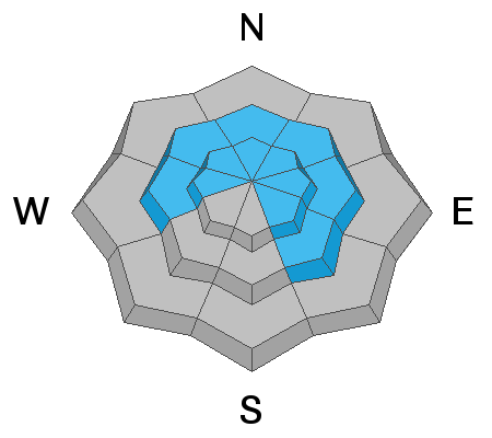
The avalanche danger is HIGH near and above treeline. The avalanche danger below treeline is CONSIDERABLE. Avalanches breaking in old snow near the ground will be catastrophic and unsurvivable.
Avoid being on or near any slope steeper than 30 degrees. Flat terrain underneath steep slopes is a dangerous place to be because avalanches can run long distances.
Avoid being on or near any slope steeper than 30 degrees. Flat terrain underneath steep slopes is a dangerous place to be because avalanches can run long distances.
What to do and where to go? The Uintas are blessed with many open meadows and rolling terrain that isn't steep enough to produce avalanches. Go to this gentle terrain today, but make sure to stay far away from any steep slopes.

Low
Moderate
Considerable
High
Extreme
Learn how to read the forecast here