Forecast for the Uintas Area Mountains

Mark Staples
Issued by Mark Staples for
Sunday, December 3, 2023
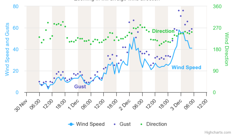
The avalanche danger today above treeline is HIGH on northwest, north, and east-facing slopes where heavy snowfall and wind drifted snow have overloaded underlying layers of old, faceted snow.
Near treeline, the danger is CONSIDERABLE on west, north, and east-facing slopes which also have overloaded old snow layers.

All other slopes that were mostly bare ground prior to this weekend's storm have a MODERATE danger for soft slabs of new snow which is upside down (denser snow on top of light snow).
THE DILEMMA - Slopes with the best coverage and the most snow prior to this storm are the ones we would like to ride to avoid hitting rocks, but these slopes are the most dangerous. For now, the best solution is avoiding avalanche terrain.
Low
Moderate
Considerable
High
Extreme
Learn how to read the forecast here
Special Announcements
The 5th Annual Avalanche Awareness Week is December 3-10. The week's goal is to save lives through activities that promote avalanche awareness, education, and safety. We have a variety of events around the state. Find an event near you.
Weather and Snow
Snowfall picked up overnight and is continuing this morning. This storm is just what we needed with warm, dense snow overnight and today to help build a base.
It's a little hard to gauge how much snow fell because it is compressing as it stacks up, but we know how much water is in the new snow. Snowfall since yesterday has 0.7 to 1.0 inches of water which seems to be 7-14 inches of new snow in the last 24 hours. The big winner is just east of Strawberry Reservoir where the Strawberry Divide SNOTEL site is showing 1.6 inches of water. Total snow since Friday is about 14-24 inches.
Another 8-10 inches of snow could accumulate today. Temperatures should only warm a few degrees. Winds peaked around 1 a.m. blowing 30-56 mph with gusts on Windy Peak reaching 70 mph. At 5 a.m. they had eased to 20-40 mph and should ease more this afternoon.
Chart of wind speeds on Windy Peak
Recent Avalanches
There have been no reported avalanches in the Uintas, but I suspect some are happening this morning.
Ad
Avalanche Problem #1
Persistent Weak Layer
Type
Location
Likelihood
Size
Description
Soft slab avalanches will fracture on persistent weak layers of old snow found near and above treeline on west, north, and east facing slopes. With strong winds blowing this morning and heavy snowfall, many of these avalanches will happen on their own and can easily be triggered by a person.
The video below shows how weak the old snow was prior to this weekend's storm. It also shows the snow on south-facing slopes that either melted away or became wet and crusty.
Avalanche Problem #2
New Snow
Type
Location
Likelihood
Size
Description
The new snow is upside down, meaning there is warmer, denser snow on top of colder, lighter snow. This set up makes travel challenging and avalanches possible until it settles, and the light snow underneath compresses.
General Announcements
Issued at 0700 on Sunday, December 3 and will be updated by 0700 Monday, December 4, 2023.
This forecast is from the U.S.D.A. Forest Service, which is solely responsible for its content. This forecast describes general avalanche conditions and local variations always occur.